
In 1903, the Boston Transit Commission proposed a connection between the East Boston Tunnel (today’s Blue Line) and the Tremont Street Subway (today’s Green Line):
In a counterfactual alternate history where this connection was actually built, it’s possible that the later-proposed Post Office Square Subway would have swallowed (for example) the trolleys that had been entering the subway at the Public Garden. Then at that point, it would be a relatively short extension to connect Post Office Square to the tunnel at Adams Square. (Plus, if the Riverbank Subway had been built, that would have diverted the Kenmore trolleys out of the Tremont Subway altogether.)
I spent entirely too much time mocking this up one evening:

The precise “date” of this mock-up is iffy, so don’t look too hard… for example, it’s probably “anachronistic” to show the Red Line extended beyond South Station Under, but no biggie.
Blue is streetcars through the East Boston Tunnel. Green is streetcars from the Public Garden portal, via Post Office Square, then to points north (following the same northerly routes as the streetcars did in real-life).
Dark Green are the “foreign” streetcars, which in this “timeline” continued to use the precursor to the Brattle Loop at Scollay Upper. (Note that the streetcar tunnel between the Brattle Loop and the Haymarket portal was quadtracked, and that Adams Square was directly under what would become the Orange Line, which is how the Post Office Square Subway would’ve been relatively easy to line up to the tunnel north of Adams, as I’ve shown here.)
Lime Green is the Riverbank Subway. (If this “timeline” were to be built out further, perhaps we would have seen the tracks connected between the Riverbank and Tremont lines… originally the Riverbank was just going to end in a loop, level with the rest of Park Street Upper, but it would have been easy to create a level junction.)
The dotted Orange is the Atlantic Ave El, which I believe even by this point was already starting to see reduced service.
As a stylistic choice more than anything else, I’ve chosen to depict the subway stations as BERy treated them — off-set station pairs. One notable feature of the Post Office Square extension proposal was the lengthy underground walking transfers:
- the two subway stations at Boylston would be connected by a east-west platform between them,
- the complex that became Downtown Crossing (but at the time were Winter, Summer, and Washington stations) would be expanded to include a station at the far end of the Red Line platform, at Otis Street,
- and then the complex that became State station would have been expanded to encompass the Blue Line Devonshire station, the Orange Line northbound State station, the Orange Line southbound Milk station, and the new station at Post Office Square
Anyway, my point is just that an East Boston-Tremont connection would have made significant impact on the topology of the network, and there would have been a lot of ripple effects — easy to imagine good ones and bad ones alike.
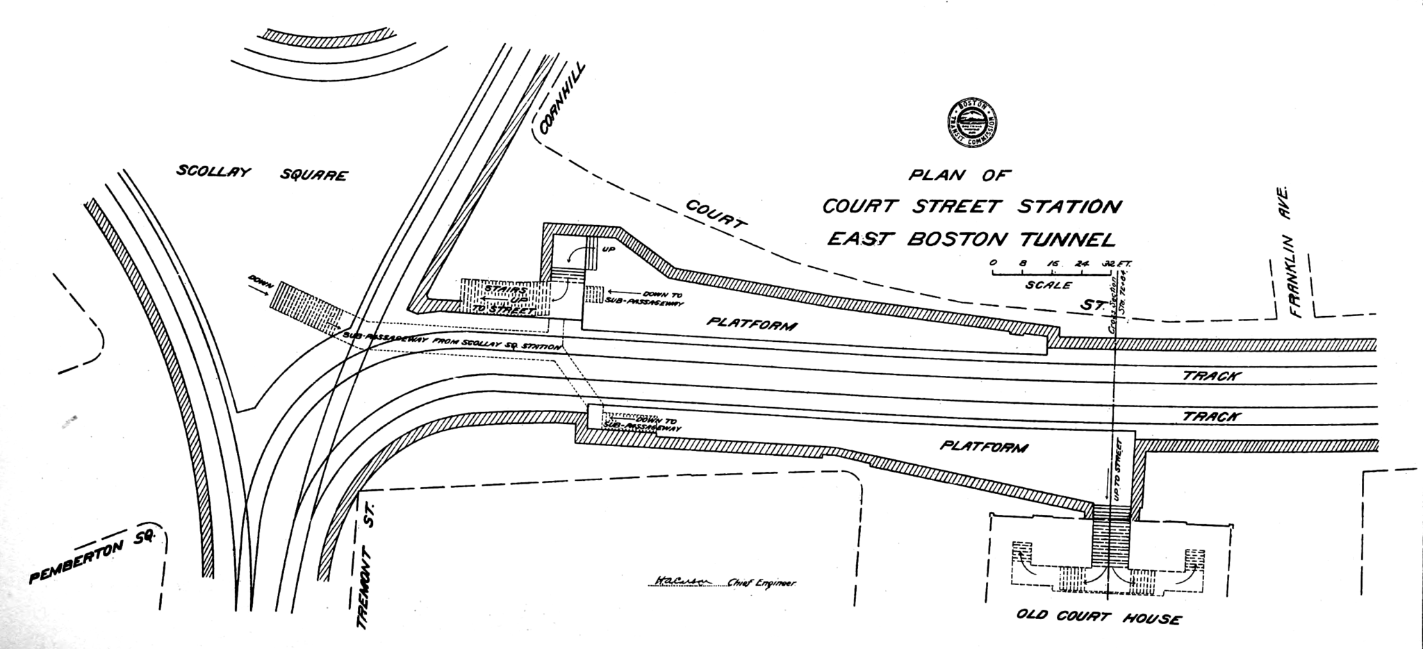
P.S. I fell deep deep down the rabbit hole, and mocked up the modifications they would have needed to make to Adams Square to connect a Post Office Square Subway. (Original source here.) Light grey indicates new tunnel, including under Devonshire, and then cutting into the loop at Adams itself. I think the turn radius for the foreign streetcars (in the darker green) would still have been within acceptable limits, although just barely. (This of course being an utterly useless exercise, since all of the infrastructure pictured here has been long demolished.)
