
In my previous post, I described how large swaths of today’s MBTA run on land that was set aside for transit use anywhere from 140 to 170 years ago. (The converse of this is also notable: how little new space has been set aside in the last five generations.) I described how, outside of the core, the T almost entirely runs on the ROWs of 19th century railroads. And I mentioned that the downtown subways were, in a sense, the “original” North South Rail Link.
The “Boston Metropolitan Railway” imagines, in loose alternate history fashion, a system where those railroads built a turn-of-the-century North South Rail Link and ran their suburban services directly through downtown, filling the niche currently occupied by the T’s subway lines. This produces a system with some similarities to Tokyo’s system or Philadelphia’s SEPTA… with some surprises.
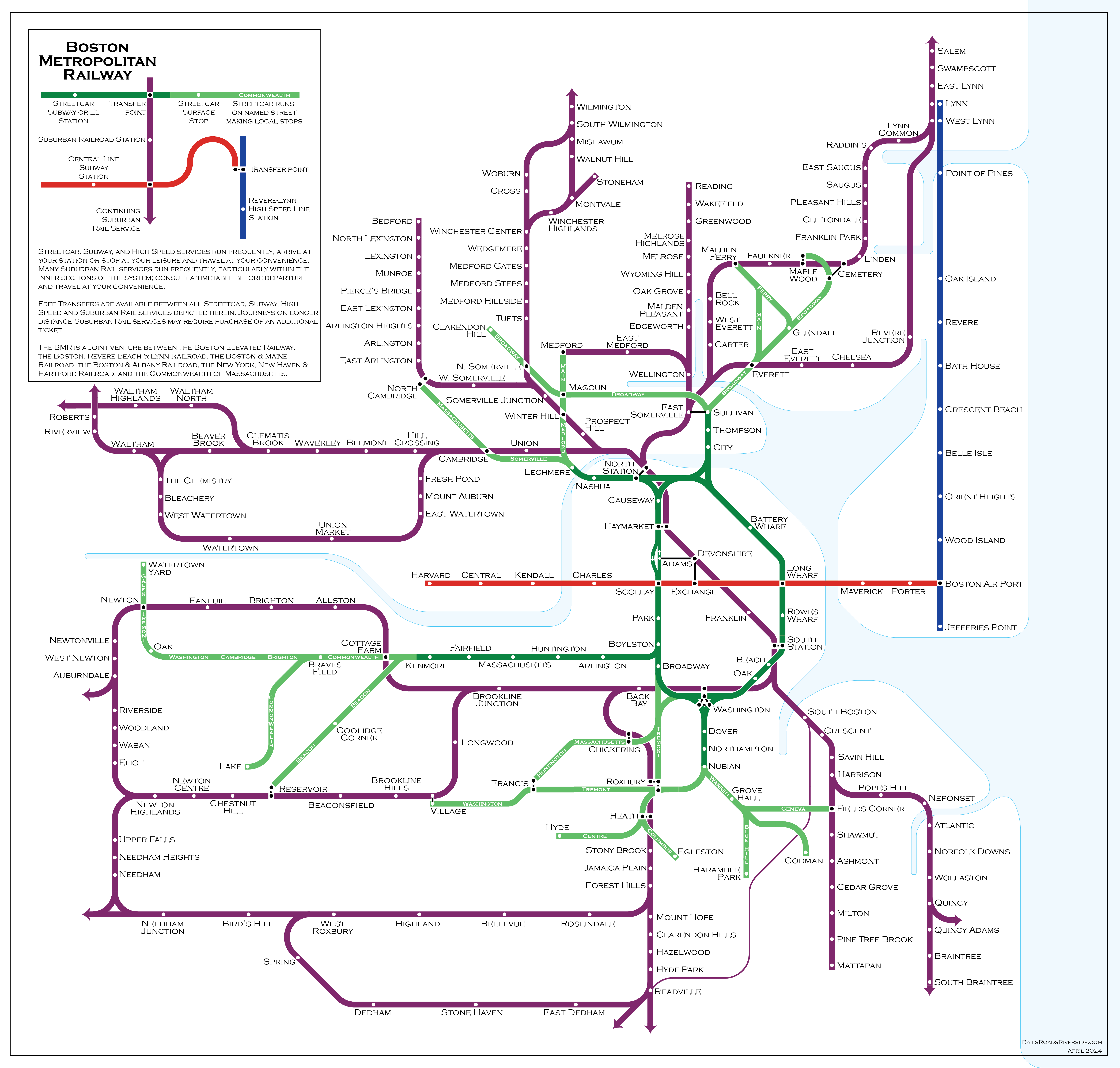
This map essentially superimposes Boston’s early 20th century railroad network on top of a modified version of its streetcar network. There are three key differences (with loose but not developed alternate history “lore” behind each):
- The Washington St, Atlantic Ave, and Charlestown Elevateds are built for streetcars, using the “Kenmore Model” still used by today’s B and C Lines, in which surface routes feed into a transfer station before running in a grade-separated ROW into downtown. The Washington St Subway (today’s Orange Line) is never built.
- The Cambridge Subway is built as an extension of the East Boston Tunnel (today’s inner Blue Line), as was originally considered in initial planning; an extension to a transfer station with the BRB&L (outer Blue Line) gave that railroad a reliable link across the harbor, allowing it to survive the rise of the automobile; the cross-harbor cross-Charles subway is called the Central Line.
- The suburban railroads somehow (magically?) build a “Suburban Rail Link” tunnel connecting North and South Stations, electrify their inner routes, and start running mid-high frequency service directly into downtown, with transfers to the Streetcar Subway, Streetcar El, and Central Line.
Don’t look too hard at the alternate history lore behind the scenes here — it’s not meant to be precise, and instead serves as source material for reimagination.
I’ll probably write more about this map in a future post, but previous readers of my blog will recognize a challenge here: core and branch capacity.
To provide “show-up-and-go” (SUAG) headways of 12 minutes or better to all Suburban stations on the above map, the core tunnel would need a capacity of 40 tph or more in each direction. SEPTA’s Center City connection, and recent analysis of the proposed NSRL, suggest that a realistic capacity for a single dual-track mainline tunnel would be about 22 tph. This imaginary “Suburban Rail Link” would need to be quad-tracked (and I don’t even know if that would’ve been possible at the time). This also illustrates a key point: providing SUAG frequencies to all suburbs requires at least two dual-track subways across downtown.
A single tunnel Suburban Rail Link
Let’s imagine what the system looks like if the Suburban Rail Link is a single tunnel with a constrained capacity of about 22 tph:
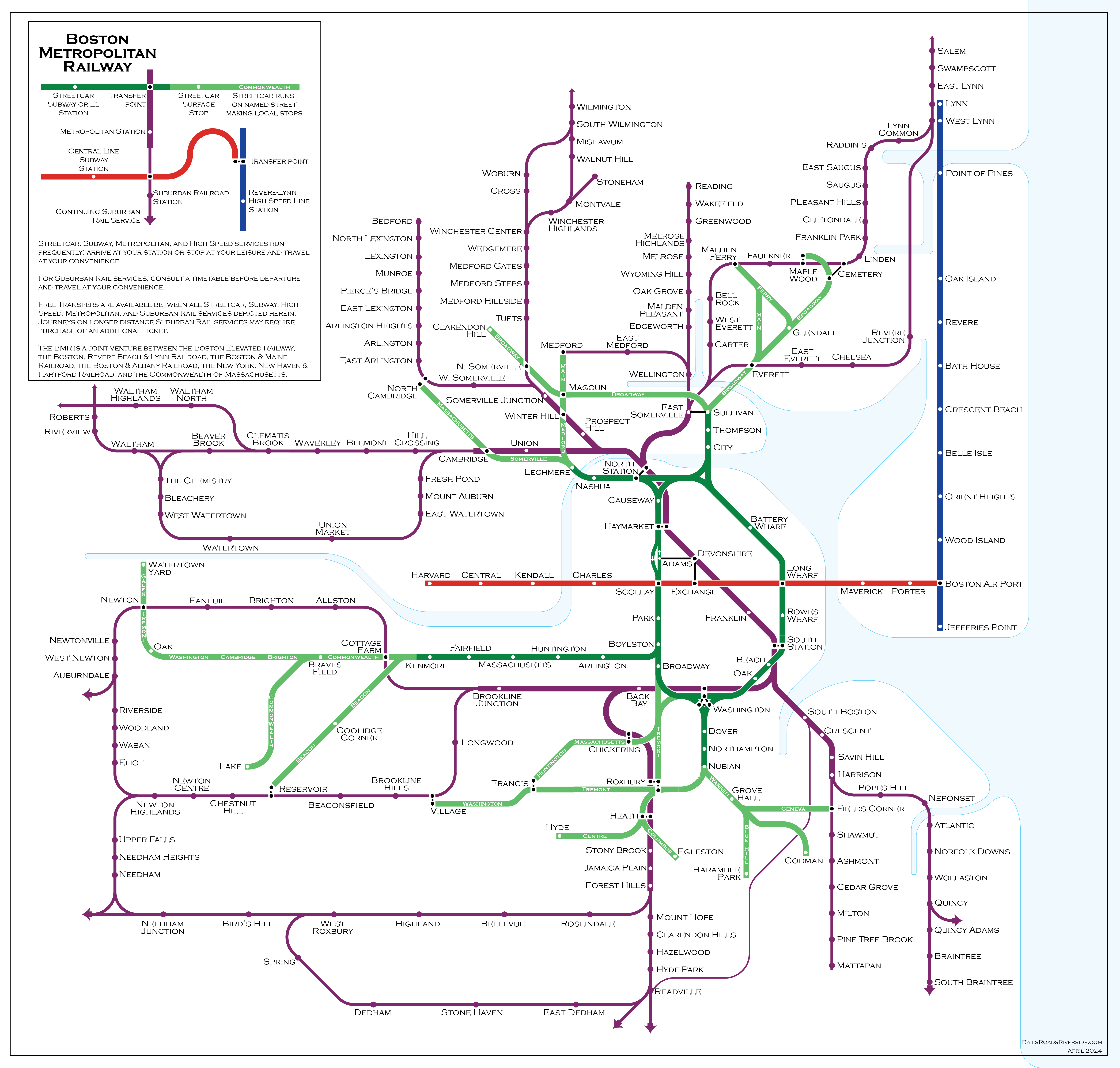
Now we get a map that looks much more like the subway maps we are familiar with, where there is a division between higher frequencies in the inner section, and lower frequencies further out. In our real MBTA, this division is largely between the subway lines and the commuter rail, whereas for the BMR it is the division between higher frequency mainline trunks (“Metropolitan” services) and lower frequency branches (“Suburban” services).
While not exactly the same, the BMR has transition points in several of the same places as today’s MBTA:
- Somerville Junction (today’s Magoun Square)
- Cambridge station (Porter Square)
- Forest Hills
Likewise, Harrison (playing the role of JFK/UMass) and Brookline Junction (Kenmore) serve as branch points for the T’s unusually long lines to Braintree and Riverside.
One key difference is the character of the SUAG frequencies: in a well-functioning version of today’s MBTA, the SUAG headways on its subway lines are usually 5-6 minutes, whereas the BMR’s Metropolitan headways would be roughly 12 minutes. The Suburban branch lines to Braintree, Riverside, and Malden would be relegated to roughly half-hour headways. On the other hand, stations like Newtonville, Hyde Park, and Chelsea would see much higher frequencies than they do today.
A pair of Suburban Rail Links
Finally, let’s imagine a third version of this map, in which two separate dual-track subways (instead of a single quad-track tunnel) are built across downtown, providing sufficient capacity for SUAG frequencies on most Suburban branches:
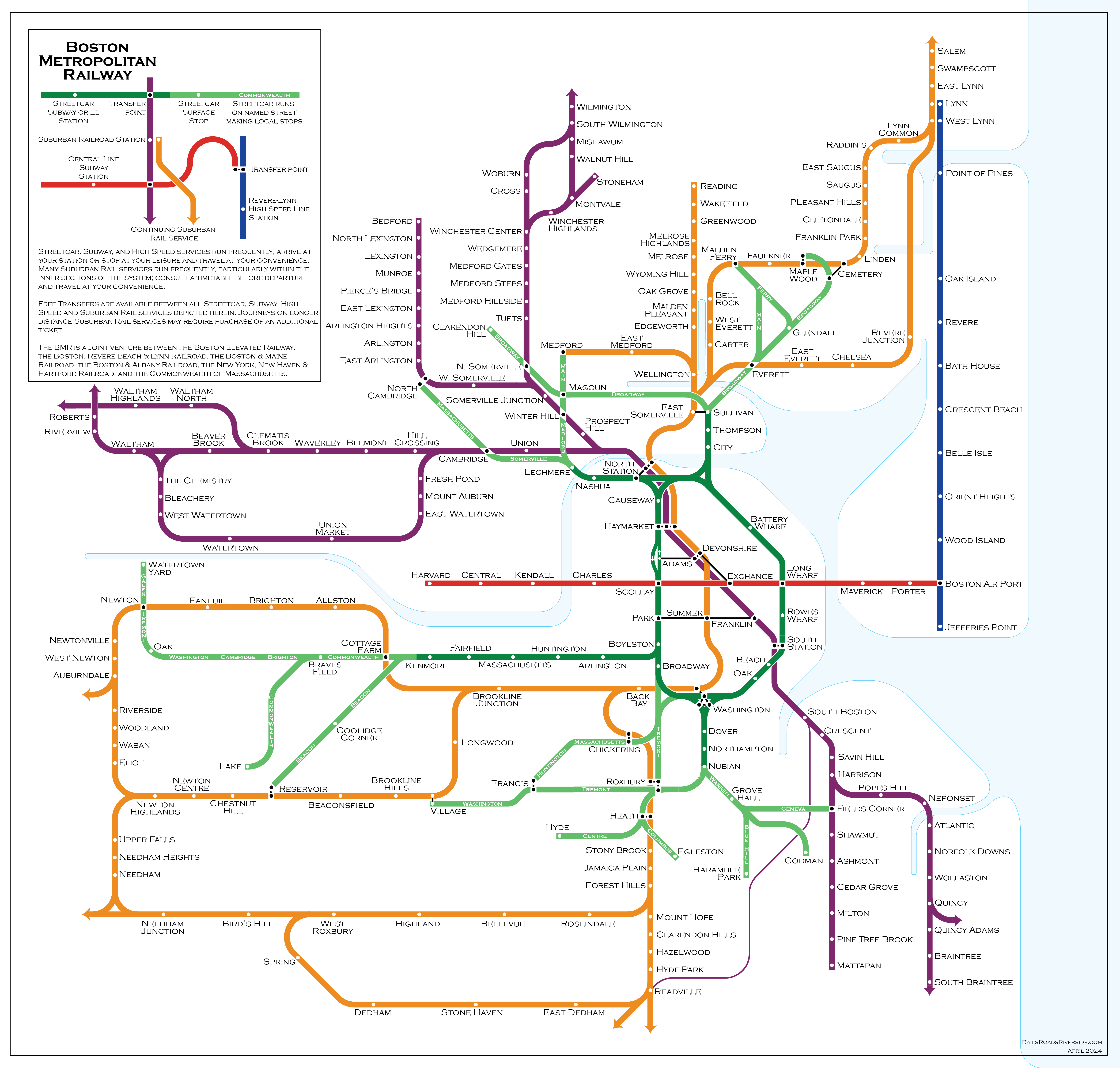
Now we start to see a convergence between the BMR’s system and the MBTA’s, made more obvious by my use of orange for the “Washington Tunnel Suburban” network. With the increased capacity, the BMR can match the MBTA’s 5-6 minute headways to
- Sullivan
- Magoun Square
- Porter
- Kenmore
- Forest Hills
- Mattapan
- Braintree
And provide 12-minute headways to the entire MBTA rapid transit system, as well as to the target corridors for higher-frequency Regional Rail, including:
- Lynn
- Reading
- Winchester
- Lexington
- Waltham
- Watertown
- Auburndale
- Needham
(The Fairmount Line is harder to analyze in this context, since it lost most of its passenger stations much earlier on, and has current stations in greenfield locations. However, it could easily be added to the purple “Franklin Suburban” network, with 6 min headways to Fairmount, and 12-min to Braintree and Mattapan.)
(The Fairmount Line was also going to be harder to map as a full line, so I admit I took the easy way out to avoid mapping it.)
Are the BMR systems “fit for purpose”? Are they better than today’s MBTA network? There are definitely pros and cons to each, but I will save those for a later post (along with some comments about the BMR’s Central Line and “Revere-Lynn High Speed Line”).
Tunnels and takeaways
These maps illustrate that serving Boston’s suburbs with SUAG frequencies physically requires the capacity of at least two downtown tunnels. The MBTA’s Orange Line addresses the need for one of these. The other “tunnel equivalent” is split between the Green Line and Red Line: the northern Red Line fulfills the Central Line’s obligation to link Cambridge and downtown, and then attempts to capture some of the niche occupied by the BMR’s Watertown, Waltham, and Lexington/Bedford branches; the southern Red Line captures the BMR’s Braintree and Mattapan branches; and the Green Line handles the BMR’s Winchester/Woburn, Lexington/Bedford, and Riverside branches.
But note that that second “tunnel equivalent” is also pulling double duty, shouldering some of the burden of the BMR’s (absurd and surely barely functional) Subway-Streetcar network, plus half of the Central Line. And note that today’s Green Line runs services in all four niches described above: Surface (B, C, E), Subway (e.g. to Kenmore), Metropolitan (e.g. to Medford), and Suburban (to Riverside).
Those niches demonstrate the final point I want to make today: the BMR thought exercise elucidates characteristics about different components of the MBTA network, in particular by dividing services up based on their distance from downtown and number of interlined branches. By better understanding those characteristics, we can design a better MBTA for the future.