
With the release of the T’s latest analysis of the Blue-Red Connector came an interesting rumor, apparently originating from comments made at an in-person public meeting: due to the need to keep the tunnel shallow (to reduce costs), the present design was not future-proofed for any extension beyond Charles/MGH.
Despite the many drops of virtual ink I have spilled on this topic, I myself am okay with this trade-off. I would rather get the thing built and live with a dead-end rather than wait another generation for it to get built.
But consideration of this topic led me to reflect more carefully on the peculiarities of the Green Line’s (western) branches, particularly the B and C. Why those two? Well, any Blue Line extension beyond Charles/MGH will be inexorably intertwined with the Green Line, whether through direct interaction, or the indirect impact of network design.
Consider, for example, a recycling of the early BERy proposal to connect the East Boston Tunnel (Blue Line) to the Boylston Street Subway, running rapid transit cars between Maverick, Kenmore, and beyond. In a modern reincarnation, an extended Blue Line might (somehow) be rerouted into the Boylston Street Subway… at which point the question becomes, what happens to the B and C?
The E, by contrast, has a path into the Tremont Street Subway via an extension along the Mass Pike into the Pleasant Street Portal. And the D can join it there by way of a D-E Connector between Brookline Village and Riverway. The B and the C, on the other hand, do not have such obvious ways to maintain connections to downtown in the absence of the Boylston Street Subway.
And even a Blue Line extension via the Riverbank alignment – as I have crayoned many times over the years – would “land” at Kenmore and then would need to either replace or complement the existing B and C Lines. Like I said, inexorably intertwined.
In any case, this is what prompted me to take a closer look at the curious case of the MBTA’s B and C Lines.
Contents
Relic of a system a century passed
As I’ve written about previously, the Tremont Street Subway was not originally designed with its current rapid transit use in mind. I argue that the best modern comparison is that it was a bus tunnel – intended to remove the congestion of streetcars from the most congested parts of downtown.
When it first opened, before the advent of true rapid transit in the form of the predecessors to the Red and Orange Lines, the Tremont Street Subway received trolleys from all over Greater Boston, including as far away as Ashmont, Forest Hills, Watertown, Arlington Heights, and Somerville’s Spring Hill. So, with one-seat-rides to many of the T’s current terminals, why was it necessary to build the Red and Orange Lines at all?
Well, consider that streetcar from Arlington Heights. Today, the 77 is scheduled to take 30 minutes to travel from there to Harvard – about 5 miles, for an average speed of 10 mph. (At rush hour, that speed often drops below 7 mph.) To trundle the 8.5 miles all the way to Park Street at those speeds would take about an hour, give or take 10 minutes. (Needing to stop every few blocks along the way.)
Compare that to the Red Line (when it was functioning properly), where the average speed historically has been about 20 miles per hour – somewhere between twice and three times as fast as a surface route. In 2016, a Red Line journey from Alewife to Park Street usually took about 18 minutes; compare that to a trolley going from nearby North Cambridge in 1899, which would have taken 35-50 minutes, if not longer.
Very quickly over the ensuing 20 years after opening the Tremont Street Subway, the Boston Elevated Railway Company did its utmost best to stop running streetcars – the buses of their day – from suburbs into downtown. The construction of transfer stations at Maverick, Sullivan, Lechmere, Harvard, Dudley, and Andrew formed a ring circling downtown at an average distance of 2 miles, demarcating what would eventually become the “Inner Belt”.
For the most part, any surface routes that ran outside of the Inner Belt were curtailed at their nearest transfer station. Only routes within the Inner Belt – the predecessors to today’s 7, 92, SL4/SL5, etc – were allowed to continue running into downtown as one-seat-rides. (This analysis is somewhat more complicated in East Boston and Cambridge, separated from downtown by water, but the general principle holds.)
The glaring exception to this were the routes that eventually became the Green Line:
- To Watertown
- To Boston College (Lake St)
- To Cleveland Circle (Reservoir)
- To Arborway
- To Egleston via Columbus Ave
Time has taken its toll on this list, culling it further. Today, only the B and C remain as surface routes that provide a one-seat-ride from beyond the Inner Belt directly into downtown.
(And to clarify, by “surface route”, I mean a route – like a typical bus route today – that makes local stops every few blocks, rather than the more distance stop spacing of rapid transit lines. The D Line is a rapid transit route rather than a surface route in this framework, despite the fact that it uses the same rolling stock as the B and C’s surface routes and, yes, runs on the surface.)
And so, as the last-standing relics of a system that was being phased out over a century ago, the B and C Lines… they’re kinda weird.
Imagining “subway-streetcar” networks to other neighborhoods
Imagine if Brookline and Allston hadn’t been the only recipients of a “subway-streetcar” network, where a surface route runs locally for 2 or 3 miles before entering a subway at the Inner Belt and running with rapid transit stop spacing into downtown.
It might have looked something like this:

Don’t look too hard at the details of this map – it’s not meant to be a particularly serious exercise. For example, it’s all-but-certain that in some alternate history where the Cambridge Subway was a streetcar subway, one of the branches would have run to the North Cambridge carhouse along the route of today’s 77; I chose not to use that alignment to confound expectations a bit, try to jar us out of the conventional routes we’re used to.
Probably the most provocative example here is the Green Line branch to Codman Square via Nubian (Dudley). The old Dudley el station was only slightly farther from downtown that Kenmore is; Codman Square is 2.9 miles of surface-running from Dudley/Nubian, which is longer than the C Line’s 2.4 miles, but comfortably less than the B Line’s 4 miles. In terms of distance and transit type, a Codman Square line is roughly comparable to a Cleveland Circle line, simply transposed into another neighborhood.
The major difference between today’s Cleveland Circle line and this allohistorical Codman Square line is the presence of the dedicated median on the unusually wide Beacon Street (something like 130 feet from sidewalk to sidewalk). Even the wider boulevards on Seaver St, Columbia Road, or Blue Hill Ave are “only” 80-90 feet wide. So I’m not trying to argue that a system like this should have been built.
Rather, I’m trying to draw attention to the degree to which the B and C Lines are unique. Nowhere else in the system can you board the equivalent of a local bus 3 miles outside of downtown and get a one-seat ride all the way into the core.
Comparing the B and C to other surface routes
In this section, I’m going to refer to figures from the 2014 Blue Book PDF. This is laziness on my part; I really should check these figures against the more recent data available on the Blue Book portal. My “justification” is the unlikelihood of any radical changes over the last 10 years, but frankly that doesn’t really hold up under scrutiny as I imagine that pandemic has caused at least some shift in ridership patterns.
This section heavily references the Blue Book’s list of bus routes mileage, bus routes by ridership, and Green Line surface ridership.
B Line
Length: At 4 miles, the B is about as long as bus routes such as the 10, 11, 18, 34, 66, 71, 73, 88, 120, 131, 134, or the 216
Ridership: At over 26,000 boardings, the B Line blows all other surface routes out of the water in terms of raw count of riders. Its ridership is comparable to (or higher than) that of the D Line, or the entire North Side commuter rail network. It is slightly less than the Braintree Branch, or the Orange Line from Jackson Square to Forest Hills.
As discussed below, there is a small class of key surface routes whose ridership sits head-and-shoulders above the rest of the network, with average weekday boardings exceeding 10,000. The B Line is roughly equivalent to two of these routes, tied end-to-end: 13,000 riders from Blandford St through Packards Corner (1.4 miles), and 13,000 riders from Harvard Ave through Boston College (2.5 miles).
Also worth noting is the distribution of ridership. Beyond Washington St on the outer end of the line, all stops except Boston College sit below 1,000 daily boardings. From Washington St inward, the average is much higher, closer to 2,000.
We could perhaps divide the B Line therefore into three segments:
- The “University Line” (Blandford St <> Packards Corner)
- The “Allston/Brighton Line” (Harvard Ave <> Washington St)
- The “College Line” (Sutherland St <> Boston College)
C Line
Length: At 2.4 miles, the C is about as long as the 30, 43, 55 (before the current cutback to Copley), 68, 69, 72, 85, or the 92. The similarity in length to the 55 (Fenway neighborhood via Ipswich St), 43 (South End via Tremont), 68 (Cambridge’s Broadway), 85 (Spring Hill), and 92 (Charlestown) is interesting to me – these routes all strike me as being similar, though I can’t put my finger on the specific quality.
Ridership: At a bit more than 12,000 daily boardings, the C Line sits comfortably in a small class of key surface routes whose daily ridership exceeds 10,000:
- SL4/SL5 (19K)
- 39 (15K)
- 28 (14K)
- 66 (14K)
- 1 (13K)
- 23 (13K)
- 111 (12K)
- 32 (11K)
- 57 (10K)
But it’s worth noting that almost all of these routes are significantly longer than the C – the major exception being SL4/SL5.
E Line
Length: the “Inner E”, running in a reservation, is just under 1 mile of surface-running. The “Outer E” is about 0.66 miles in mixed traffic. A little bit less than 1 mile additionally runs in a subway leading into Copley. End to end, the branch is roughly 2.4 miles, the same as the C.
Ridership: Overall, the E sees about 18,000 boardings, giving it the highest per-mile ridership of all four branches. About 16,000 of those boardings come from the subway + Inner E (1.8 miles), and the 4 stops on the Inner E (Northeastern, MFA, LMA, Brigham Circle) themselves provide nearly 11,000 boardings – almost equal to the entire 2.4 miles of the C Line, compressed into less than 1 mile.
(The E Line really should be in a subway.)
Crayoning truncated versions of the B and C
This post was prompted by the notion that crayon extensions of the Blue Line beyond Charles/MGH might not be feasible, and implicitly by the notion that an extended Blue might instead take over the Boylston Street Subway, cutting off the B and C from downtown.
That is probably a relatively improbable scenario. What might be moderately more likely is a truncation of these two legacy surface routes in the midst of a conversion of the Boylston Street Subway to “light rail heavy metro” – akin to the D Line, with dedicated and (nearly) fully sealed ROWs. That could be done without figuring out how to run trains from Maverick to Kenmore, and therefore represent a more likely scenario where the B and C might be truncated.
Truncating the C
The C was built to be truncated, with the inclusion of the Kenmore Loop, with the long-term vision of converting the B to rapid transit (see below), akin to Maverick’s original conversion.
Is this a good idea? I don’t know. Was it a good idea to truncate the 57 and 39? It was arguably better for the system overall, but probably was worse for those riders.
Objectively, the numbers for the C are good; if it were a standalone bus line (and assuming all current riders would be willing to transfer at Kenmore), it would easily be in the top 10 if not top 5. But, to put it another way, if the C didn’t exist, would that corridor be a high priority to construct a new light rail line?
The US Census’s interactive map is not really designed for high-density areas, so I took a screenshot and added additional colors, going tract by tract, to distinguish between areas of “high density” and “very high density”. And we can see that the Beacon Street corridor doesn’t really stand out:

There’s density, especially around Coolidge Corner, but generally no more than wide swaths of Cambridge and upper Dorchester, with some areas seeing even lower density than that. (Contrast that with both the Huntington and Commonwealth corridors, see below.)
The Beacon Street corridor sees comparable density to the southwestern corners of Cambridge, and is farther away from downtown. Isn’t it weird that so much more of Brookline enjoys a one-seat ride into Downtown?
As a visual, here are the 10-minute walksheds from Central and from the C Line:
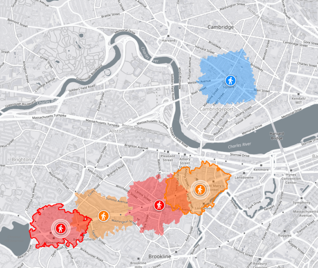
And here are those walksheds with my attempt to overlay the higher-density census tracts along those corridors (lower density tracts are unmarked):
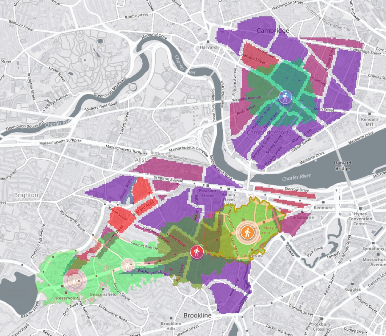
Notice how the lower density areas along the eastern and western peripheries of Beacon Street still have a 10-minute walk to an OSR, while the larger swaths of higher density in Cambridge simply need to make a longer walk or transfer via a bus.
So… I’m not saying the C should be truncated, but I am saying it’s kinda weird that it never has been, and it certainly makes it exceptional.
Truncating the B
Like I mentioned above, the B is almost like two surface routes strung together into one. The “University Line” and the combined “Allston/Brighton/College Line” would each be roughly equivalent to the C Line. I suspect that those routes would get split up if truncation were ever seriously considered.
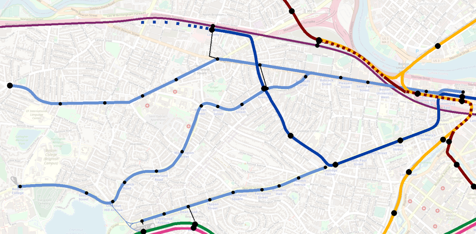
First of all, if “heavy metro” rapid transit ever comes to Kenmore, it will need someplace to go from there. Assuming the Highland Branch gets handled by a service out of Huntington (in a D-E Connector world), the logical corridor for a heavy metro extension would be Commonwealth.
How far down you extend down Commonwealth would be an open question, and probably a target that would move over time, and would depend on how a few different factors evolve. In all cases, however, I think it would make sense to extend the heavy metro line at least to Boston University.
(Note that I’m going to use the color blue on these maps, but these are intended to agnostic as to what happens to this “heavy metro” line east of Kenmore. Probably it would still be a branch of a modernized “Green Line”, but it would be unrecognizable compared to today’s, so I wanted to use a different color.)

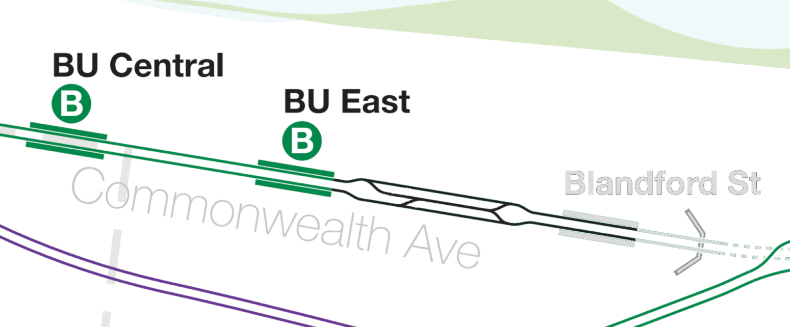
As an employment hub in its own right, I think BU would make for a logical transfer point for a truncated B Line. The set of pocket tracks west of Blandford even provide the makings of a very basic yard for turnbacks:
In terms of where to extend a heavy metro line after BU, I think there are a number of options. It depends on whether you want to hit West Station, how much you want to future-proof for future extensions (which, in all practical terms means, “How easy do you want to make it to eventually bring the heavy metro line back to the Mass Pike ROW?”), and how much you want to prioritize directly serving the high population density around Allston’s Union Square and Harvard Ave. Larger systemwide factors – such as circumferential service to West Station or high-freq regional rail with a North-South Rail Link – would also influence the choice of alignment.

In the West Station alignments, I think you’re probably looking at maintaining the Boston College <> Boston University line described above. (I think the cut south from West Station back to Packards Corner is relatively unlikely, but even then the Babcock St/St Paul St stretch could still handle a streetcar line in addition to heavy metro service to West Station.)
In the southerly alignments, you might perhaps look at a transfer station in the vicinity of Union Square/Harvard Ave, or perhaps you go all out and embrace BERy’s original plan for a transfer station at Warren St (though I have no idea where you’d go after that, unless you’re willing to dig up the entire path of the A Line to build a subway to Newton Corner via Oak Sq).
One last crazy crayon idea
Presented without further comment.

(Okay okay, I can’t help myself, so here’s a brief comment. The idea here was to “harmonize” alignments serving the high ridership destinations at Boston University, Coolidge Corner, and Harvard Ave, as well as absorb a little bit of the catchment that would be lost by converting the Fenway Branch to circumferential service. A small network of streetcar lines — on western Beacon, Comm Ave, and the old A Line — would provide feeder service, and maintain the micro-network based out of Boston University. [Heck, you could even keep the Beacon Line as-is, terminating at Kenmore providing local service above the Beacon Subway, and delete the subway station around Hawes St.] A strong circumferential service would ensure connectivity to West Station, and a terminal/transfer station at Boston Landing would provide transfers from regional rail, as well as set up subsequent extensions along the B&A, e.g. to Newton Corner. This design would also let West Station do some of the “heavy lifting” for radial service, and “free up” the new “heavy metro” to focus a bit further south.)
(As to why this is a crazy crayon: tunnels. So many tunnels. Crossing over from BU to Beacon is Ugly with a capital U, and almost certainly would not be cut-and-cover. And then tunneling under Harvard Ave would be an absolute adventure that would again almost certainly not be cut-and-cover. But, I mean… if we as a country continue our love affair with deep bore tunneling, then the alignment via Coolidge Corner [2.7 miles] actually would not be that much longer than the alignment via West Station [2 miles]. If we’re gonna spend big on a project like this, then I suppose why not spend big?)