
Introduction
The MBTA’s Blue Line is one that has frequently captured the imagination of amateur transit planners. A proper HRT line like the Red and Orange Lines, but much shorter, and terminating in downtown Boston. Proposals to extend the Blue Line to the northeast to Lynn and beyond have been floating around for most of a century now, and the so-called “BLX” project is one that is alive and well and commonly discussed in the domain of “serious” proposals.
At the other end, there is an active proposal to extend the Blue Line west the short distance to Charles/MGH, to provide a badly needed connection to the Red Line. (This is the rare extension that is entirely missing from BERy’s proposed expansion map from 1945.) Personally, I think this is pretty likely to be built in the next 15 years, and I suspect it will be the next major project that advocates focus on once GLX finally opens.
For amateur transit planners, that terminus at Charles/MGH beckons for extension. “It’s a whole untapped HRT line!”, we say to ourselves. “With its own tunnel through downtown and to the airport to boot! Surely it’s worth extending it… somewhere.”
This post is the first in a series that will examine the different possibilities for extending the Blue Line west from Charles/MGH. Today’s post reviews some historical background that is relevant for this topic. Subsequent posts will review specific proposals, and the benefits and challenges of each.
Why isn’t there an obvious answer?
The first thing to acknowledge is that there is not an obvious answer for where the Blue Line should go west. Though it may not seem like it, this is actually a big deal. For all other major endpoints, there is general consensus for feasible corridors:
- Wonderland: northeast to Lynn and beyond
- Oak Grove: north to Reading
- Medford/Tufts: north toward Winchester
- Union Square: northwest toward Porter and beyond
- Alewife: northwest toward Arlington and/or west to Waltham
- Riverside: no further extension, as you’ve already reached Route 128
- Forest Hills: southwest to Roslindale Village and/or south to Readville
- Ashmont: convert the Mattapan High Speed Line to HRT
- Braintree: no further extension (already reached the proverbial Route 128 boundary, even though, yes, it’s technically not Route 128 at that point)
That brings us back to that 1945 map. By and large, these corridors have been identified for a century, and are closely tied to the paths Massachusetts’ original railroads struck out in the 19th century.
But as you can see, there is no vision for where the Blue Line should go in 1945.

Now, to be clear, I am not saying that there’s nowhere for the Blue Line to go simply because transit planners in 1945 had no ideas. But it gives us a clue as to why there isn’t an obvious corridor — and for that, we need to look further back into history.
The Blue Line is half a line — and the Green Line has the other half
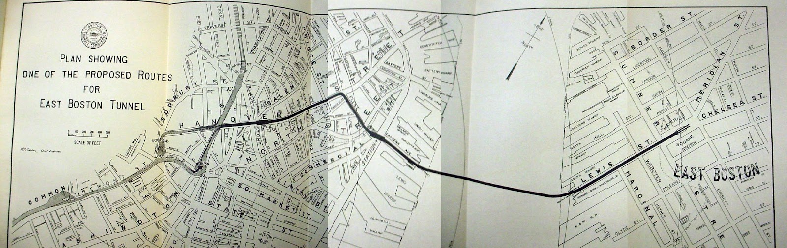
A brief refresher: the Tremont Street Subway opened in 1897 between Boylston and Park, enabling the street above to be liberated from the crush of streetcars coming from all over the city. The rest of the subway opened, running from Haymarket to Pleasant Street (south of today’s Boylston station), providing a north-south spine for streetcar service through downtown. In 1906, a tunnel opened between downtown and East Boston — today used by the Blue Line, but originally used by streetcars, providing a east-west complement to the Tremont Street Subway.
In the early 1920s, the East Boston Tunnel was converted to “rapid transit”, as they called it at the time: platforms were raised to high level, streetcar routes were truncated to a transfer station at Maverick, and heavy rail rolling stock — like those used on the Cambridge-Dorchester Subway and the El — replaced the streetcars in the tunnel. BERy was seeking to replicate successful models used at Harvard, Sullivan, Dudley (now Nubian), Forest Hills and others: maintain streetcars as local feeder services into large transfer stations where passengers can be whisked downtown by rapid transit.
Ideas to unify the Central Subway with a link to East Boston have been around since the subway was first envisioned. You can see on Vanshnookenraggen’s Flickr an early plan to hook the East Boston tunnel (in planning at the time) directly in to the subway, via the loop at Scollay Square. (I can’t remember right now exactly when this particular map dates from, but I believe it’s late 1890s.)
In the early ‘20s, at the same time that the East Boston Tunnel was being converted to Rapid Transit, efforts were underfoot to do the same on what would become the Green Line. Those efforts are worth a post of their own, but suffice it to say that plans were grand.
One such plan — dating from 1926 — is illustrative for our present question. In addition to converting both the proto-Blue Line and proto-Green Line to full HRT rapid transit, this proposal also called for hooking the East Boston Tunnel into the Central Subway by way of Park Street, and then take over the subway to Kenmore and beyond. (You can view the original high-res map on Wikimedia Commons.)
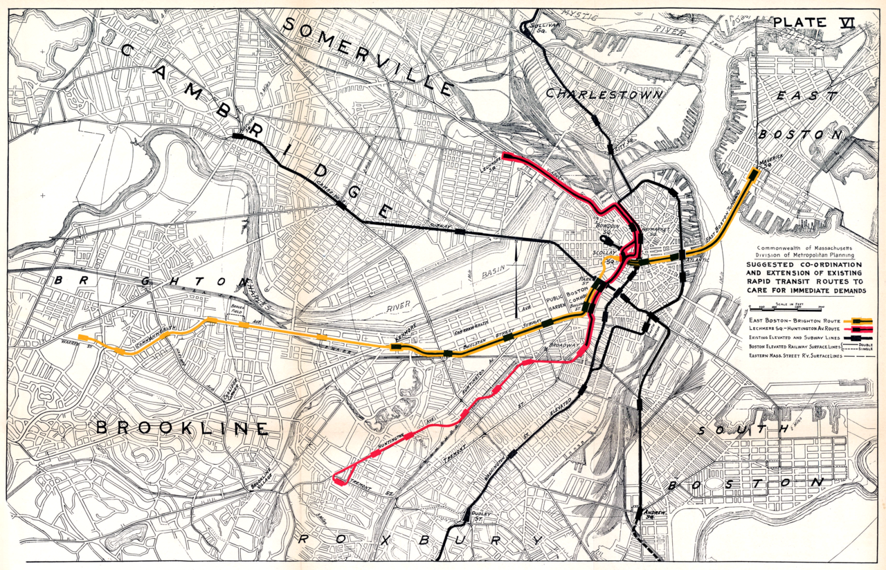
As you can see, this proposal breaks the Green Line in half, and gives half of it to the Blue Line. And let’s be clear: then and now, the corridor from Longwood to Huntington to Back Bay to downtown to Lechmere absolutely merits a rapid transit line of its own. The Green Line of today pulls double duty, covering the role of at least two rapid transit lines, if not more.
Broadly heading west from downtown, there are three broad corridors, each meriting rapid transit: Boylston Street, Huntington Ave/Southwest Corridor, and Washington Street. The 1926 proposal lines up the proto-versions of the Blue, Green, and Orange Lines, and launches them out to those three corridors, one by one.
This proposal, had it come to fruition, would have created a very balanced network, with relatively evenly spaced “spokes” radiating out from downtown, and each major corridor covered.
So, as seen here, it is possible to design a Boston subway system with 4 “full” lines, each with fully developed “legs” running into downtown. Today’s network — 2 full lines (Red and Orange), 1 half line (Blue), and 1 half-ish line (Green, at least until GLX opens) — is not an inevitability.
Since the 1926 plans never came to fruition, we instead had the Blue Line and Green Line each running into downtown and basically terminating there. The 1926 plans illustrate how reasonable it would have been to consolidate the existing Blue Line and existing Green Line into a single line, and thus illustrate how the Green Line has essentially been acting like the second half of the Blue Line.
(Imagine if the Red Line were two lines: A Crimson Line running from Cambridge to South Station, and a Purple Line running from Post Office Square to South Station to Andrew and beyond. Both lines terminate downtown in this example, but very logically could be stitched together, forming a natural corridor through the core. I’m arguing that the same is true of the Green and Blue Lines: just as the hypothetical Crimson and Purple Lines combine to make the Red Line, the Green and Blue functionally combine to create a single corridor through the core.)
The Green Line has taken over what would have been the logical western half of a full-build crosstown Blue Line. This is why there is no obvious “next step” beyond Charles/MGH: the Green Line has been taking care of the East Boston Tunnel’s western counterpart all this time.
Why can’t 2026 be like 1926?
By which I mean, why can’t we take the 1926 proposal and use it today? There are quite a few reasons, and many of them overlap with other challenges for crayoning the Blue Line west, which I’ll describe in subsequent posts.
The first and most immediate reason is that the 1926 proposal called for a tunnel under the Boston Common to connect then-Scollay Square Station with Park Street Station so that the “Blue Line” could hook into the Tremont Street Subway and Boylston Street Subway. While I wouldn’t want to say that a new tunnel under the Boston Common will never happen, it’s extremely unlikely. Moreover, hooking a new subway into Park Street would almost certainly require massive modifications to the existing station.
The larger reason, which is illustrative of the general challenges of planning a westward extension of the modern Blue Line, is that the Green Line is no longer the vaguely mirror image of the East Boston Tunnel it once was. The Green Line has become an entire subnetwork of its own, with potential for radical expansion, and a century’s worth of inertia behind the current design. It has grown beyond what it was in 1926, and can’t be quite so easily replaced.
In the next posts, we’ll go through different proposals from past and present, examining the benefits and challenges for each.