
Last summer, I wrote that 2022 marks the (true) centennial of the Green Line, with the 1922 opening of the Lechmere transfer station commencing a transition from the “local streetcar network” model to the “rapid transit” model. I point to the rapid demise of the streetcar network in the ensuing two decades as evidence of an intentional transformation.
Contents
Understanding the pre-transformation network
To understand the scope and scale of that transformation, it’s worth looking at what the “subway-streetcar network” looked like immediately before that transformation. One might think that that would be a simple task: simply Google 1921 BERy map boston and this is the first result:
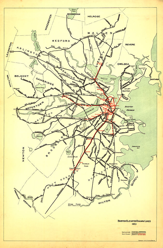
Except… this map doesn’t tell the whole story. A little bit of further digging reveals that many of the surface lines on this map didn’t actually operate into the subway – the far-flung lines in West Roxbury, for example. Moreover, this map omits the foreign cars that weren’t run by the Boston Elevated Railway but still operated into the subway, turning at the Brattle Loop.
Finding the “subway-streetcar routes”
Identifying which routes operated into the subway 101 years ago is actually not a simple task. Again, I believe this is a consequence of how BERy saw the Tremont Street Subway: it wasn’t a rapid transit line and it wasn’t a “trunk” of the network – it was just a way to get streetcars off of congested streets in downtown. From what I’ve seen, it probably never would have even occurred to BERy officials to publish a map of the “subway-streetcar network” – they were all just “surface lines”.
Making matters more difficult is that BERy also did not (to my knowledge) publish public timetables for specific routes. There were internal timetables, though my understanding is that they were very internal indeed, and are difficult to parse a century later. Most notifications of changes in routes, for example, appear to have occurred in newspaper announcements.
The Map
Here I am indebted to the labors of love of numerous local transit historians. Building on their work, I have created what I believe is the first map of its kind: a full diagram of all BERy services that offered one-seat rides into the downtown subways in 1921.
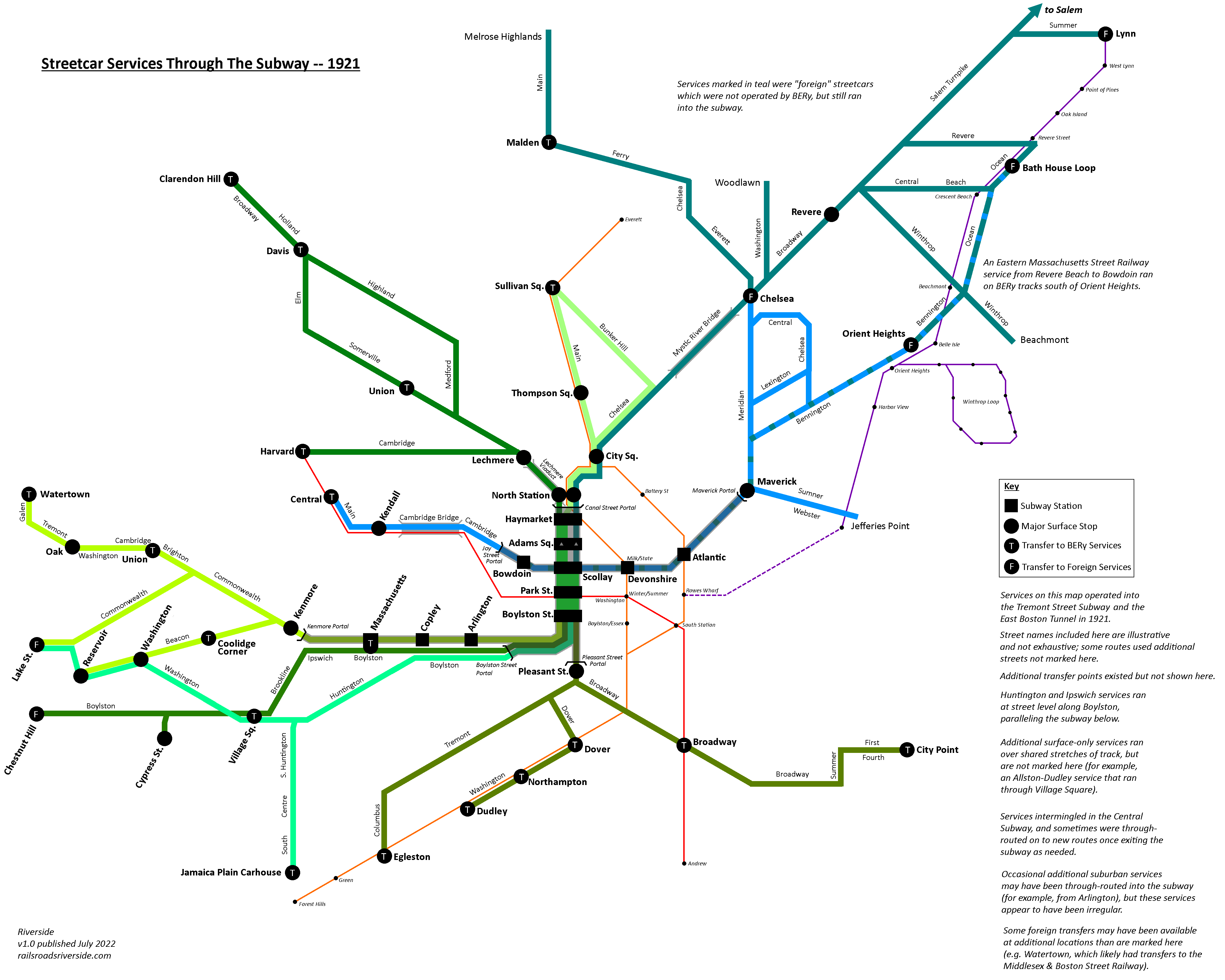
Applying the anachronistic visual language of today’s Green Line and Blue Line, I’ve framed the 1921 network with modern points-of-reference, to make it easier to understand its scope and complexity.
Again, it’s important to understand that this diagram does not represent how BERy officials or riders would have conceptualized their system. However, thinking of the streetcar network in these terms is also vital for understanding the decline of Boston’s streetcar network (which began much earlier than we often think of it as.)
List of Routes
The routes operating into the subways included the following (note that many routes had short-turn turnbacks, the same way some trains on today’s E Line terminate at Brigham Circle); I have included some modern comparisons based on today’s routes in parentheses:
Kenmore Portal lines
- Watertown (57)
- Lake Street [Boston College] via Commonwealth Ave (B)
- Reservoir [Cleveland Circle] via Beacon Street (C)
Ipswich Street lines
- Chestnut Hill and the Cypress St Carhouse (55 + 60)
Huntington Ave lines
- Lake Street [Boston College] via Village Sq [Brookline Village] (E + 65)
- Jamaica Plain Carhouse (just south of Jamaica St) (E + 39, but not all the way to Arborway/Forest Hills)
Pleasant St Portal lines
- Egleston (43)
- Dudley [Nubian] (similar to SL5, but on Dover St [East Berkeley St] from Washington to Tremont)
- City Point (9)
East Boston lines
- Central Square, Cambridge via Joy St Portal (no equivalent, but somewhat similar to the proposed Blue-Red Connector)
- Jefferies Point (120)
- East Boston and Chelsea (114/116/117, 112, and 121)
- Orient Heights (120)
- Revere Beach (paralleling the route of today’s Blue Line on Bennington St and Ocean Ave)
Lechmere lines
- Harvard (69)
- Davis, and Clarendon Hill, via Somerville Ave or Highland Ave (87 and 88)
Canal Street Incline lines
- Sullivan via Main St (92)
- Sullivan via Bunker Hill (93)
Foreign streetcars
- Beachmont (using part of today’s 119)
- Revere Beach (116 and 117)
- Lynn (probably most similar to today’s 455)
- Salem and the North Shore (450)
- Woodlawn (111)
- Melrose Highlands via Malden & Chelsea (I believe roughly using today’s 131 north of Malden Center)
Acknowledgements
This has been a gargantuan project, far more perhaps than the map itself would suggest. The details needed to pinpoint the system exactly as it existed in 1921 are numerous and scattered. As in my previous post, I must heartily thank the army of transit historians who have come before me, including Ron Newman, Bradley Clarke, O.R. Cummings, Frank Cheney, and Anthony Sammarco.
I want to extend a special thanks to DAS, who has expertly collated the primary source material upon much of this map is based, enabling us to expand, contextualize, and occasionally correct the work done by Newman, Clarke, Cummings, Cheney, Sammarco, and others. His expert review caught many errors of mine, answered numerous arcane questions of mine, and uncovered the fine details at the margins of this project to ensure this map was as accurate as possible.
When I was a child, reading the copy of Trolleys Under The Hub my parents had given me, my imagination was enchanted by the idea of a “Green Line” that apparently had so many branches. This is the map that I had wanted to see then, so it is a profound delight to finally see it brought to life; as such, I offer my profound thanks to all those who helped me create it.
Notes and Further Reading
As printed in the image:
- Services on this map operated into the Tremont Street Subway and the East Boston Tunnel in 1921.
- Street names included here are illustrative and not exhaustive; some routes used additional streets not marked.
- Additional transfer points existed but are not shown here.
- Huntington and Ipswich services ran at street level along Boylston, paralleling the subway below.
- Additional surface-only services ran over shared stretches of track, but are not marked here (for example, an Allston-Dudley service that ran through Village Square).
- Services intermingled in the Central Subway, and sometimes were through-routed on to new routes once exiting the subway as needed.
- Occasional additional suburban services may have been through-routed in the subway (for example, from Arlington), but these services appear to have been irregular.
- Some foreign transfers may have been available at additional locations than are marked here (e.g. Watertown, which
likelyalmost certainly had transfers to the Middlesex & Boston Street Railway).
I recommend the following books on this topic:
- Trolleys Under The Hub, by Frank Cheney & Anthony M. Sammarco
- Boston In Motion, by Frank Cheney & Anthony M. Sammarco
- Tremont Street Subway: A Century of Public Service, by Bradley H. Clarke & O.R. Cummings
- Boston’s Main Line El: The Formative Years 1879-1908, by George Chiasson, Jr.
- Street Cars of Boston, volumes 1 through 6, by O.R. Cummings
- Streetcar Lines of the Hub: The 1940s, by Bradley H. Clarke
- Boston’s MTA: Through Riverside and Beyond, by Bradley H. Clarke
References
Tracking down which routes were running into the subway in 1921 was surprisingly difficult. When possible, I’ve used primary sources, but in some cases have relied on secondary sources, particularly since some transit historians have obtained access to archive materials that are more difficult to access remotely or as a member of the public.
I did a poor job of cataloguing my references when building this map. As such, I am currently in the process of rebuilding the reference list for this post. My WIP reference list is available as an appendix to this post.