
Contents
Kenmore Portal lines
- Watertown (57)
- Lake Street [Boston College] via Commonwealth Ave (B)
- Reservoir [Cleveland Circle] via Beacon Street (C)
While I’m sure it’s not controversial to claim that the predecessors to the A, B, and C ran into the subway in 1921, I still intend to track down the attestations for these.
Ipswich Street lines
- Chestnut Hill and the Cypress St Carhouse (55 + 60)
An excellent history is available on Wikipedia. Attestations of this service in 1921 include
- Chasson, George Jr. (1987). Lonto, Arthur J. (ed.). “Boston’s Main Line El: The Formative Years 1879–1908”. Headlights. Electric Railroader’s Association. 49: 20–21.
- Barber, Richard (March–April 1984). “Fifty Years Ago… The Last Days of Cypress Street Carhouse”. Rollsign. Vol. 21, no. 3/4. Boston Street Railway Association. pp. 3–7.
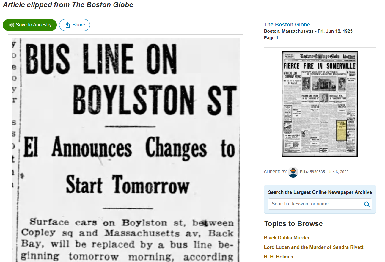
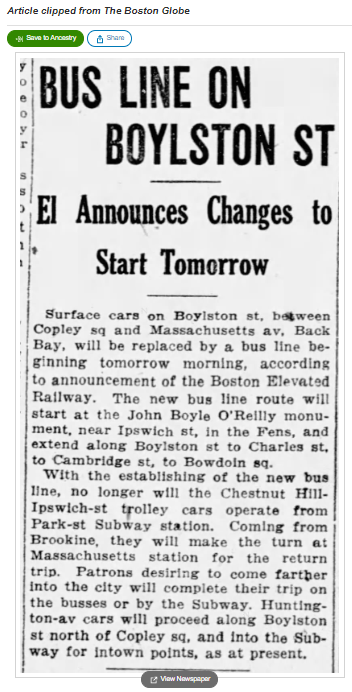
The cutback of this service in 1925 is documented in the Boston Globe
Huntington Ave lines
- Lake Street [Boston College] via Village Sq [Brookline Village] (E + 65)
- Jamaica Plain Carhouse (just south of Jamaica St) (E + 39, but not all the way to Arborway/Forest Hills)
Happily for us, these routes are clearly attested in a late-1921 Boston Globe article, which read in part:
Four different lines are now operated on Huntington av, it is explained by the trustees in a statement issued yesterday. These lines go from Park st to the Opera House, to Longwood av, to Lake st via Brookline Village and to Jamaica Plain via South Huntington av.
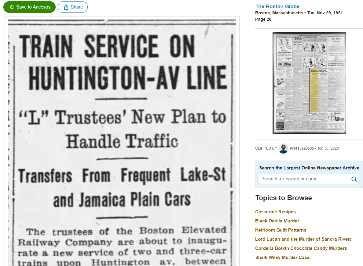

This article also announced that services on Huntington were being shifted to what is essentially a mirror of the Lechmere transfer station model: high-capacity trains running between Park St and Brookline Village, and shorter trains operating between Brookline Village and Lake St, and between what is now the Riverway stop and the South Huntington carhouse. This is a further example of the radical shift in thinking that occurred in the early 1920s, and which I argue marks the birth of the modern Green Line.
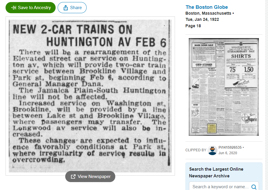
A follow-up article three months later in early 1922 suggests that the plan was later modified to maintain the one-seat ride between South Huntington and Park St:
Pleasant St Portal lines
- Egleston (43)
- Dudley [Nubian] (similar to SL5, but on Dover St [East Berkeley St] from Washington to Tremont)
- City Point (9)
The Egleston and City Point routes survived well into the MTA era, though I am still tracking down specific attestations for their exact form in 1921.
The Dudley route was bustituted in 1938, but was shown on BERy’s 1936 map to cut over from Washington St to Tremont St via Dover, and enter the Pleasant Street Portal via the Tremont Street leg (alongside the Egleston line).
This seems curious to me – why didn’t the Dudley streetcar line keep to Washington St until Broadway and cut over to the Portal there? I’m not sure, but upon reviewing multiple maps from 1904, 1904 again, and 1917, I see no indication of a physical connection via Broadway/Pleasant St between Washington and Tremont. I’ve found ambiguous indications of such a connection starting in 1923, but the 1936 map shows that connection only being used by the City Point line.
On the balance, it looks to me like the Dudley line most likely did indeed employ the “Dover jog” in 1921, but I will update this page when I find a more precise indication.
East Boston lines
- Central Square, Cambridge via Joy St Portal (no equivalent, but somewhat similar to the proposed Blue-Red Connector)
- Jefferies Point (120)
- East Boston and Chelsea (114/116/117, 112, and 121)
- Orient Heights (120)
- Revere Beach (paralleling the route of today’s Blue Line on Bennington St and Ocean Ave)
In progress.
Lechmere lines
- Harvard (69)
- Davis, and Clarendon Hill, via Somerville Ave or Highland Ave (87 and 88)
In progress.
Canal Street Incline lines
- Sullivan via Main St (92)
- Sullivan via Bunker Hill (93)
The Canal Street routes survived well into the MTA era, though I am still tracking down specific attestations for their exact form in 1921.
Foreign streetcars
- Beachmont (using part of today’s 119)
- Revere Beach (116 and 117)
- Lynn (probably most similar to today’s 455)
- Salem and the North Shore (450)
- Woodlawn (111)
- Melrose Highlands via Malden & Chelsea (I believe roughly using today’s 131 north of Malden Center)
In progress.