
This page will be updated to align with the Gold Line project that I’ve described elsewhere. For the moment, some of the labels and colors will be different, but the capital improvements would be the same. I refer here to stations named “Tremont” and “Shawmut Ave”, in order to differentiate the locations of platforms and construction; after construction, those stations would together be called “Bay Village”.
This page documents my design for a new set of LRT stations in the vicinity of the old Pleasant Street Portal, in the Bay Village neighborhood of Boston. This design is intended to support multiple services:
- Downtown <> Huntington Ave, with continuing service to Heath St, Riverside, and Needham (using a “D-E Connector” between Riverway and Brookline Village)
- Seaport <> Huntington Ave
- Downtown <> Nubian via Washington St
- Downtown <> Nubian via Albany St (optional)
This design utilizes flying junctions to minimize conflicts and maximize capacity. This design also:
- leverages extant infrastructure as much as possible
- limits tunneling to the public right-of-way as much as possible
- primarily uses cut-and-cover tunneling
- focuses tunneling in “clean” areas that were cleared of utilities and other underground artifacts during the construction of the Mass Pike
Contents
Diagram
Depths and Incline Grades
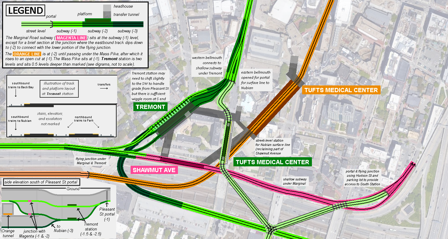
Most of this proposal can be understood in terms of “Levels Below Ground,” where street level is (0), the Mass Pike is (-1), the Orange Line tunnel under the Pike is (-2), and a hypothetical tunnel below that is (-3). In general, each level corresponds to 17-20 feet of depth, though this is only an approximation. Most of the tunnel depths can be understood within these broad categories of “levels”.
From my read of the 1999 edition of the TCRP Track Design Handbook for Light Rail Transit, page 73 in the PDF, 7% is the steepest recommended grade for LRT vehicles, as long as (I think) the incline is less than 500 feet long. Targeting a grade of 6.9% and assuming that each “level” corresponds to 18 feet of depth, we can assume that it take 260 feet of horizontal distance to transition from one level to another.
“Beyond the edges” of the diagram: the Back Bay Subway, the Nubian Subway/Surface Line, and a reactivated Pleasant Street Portal
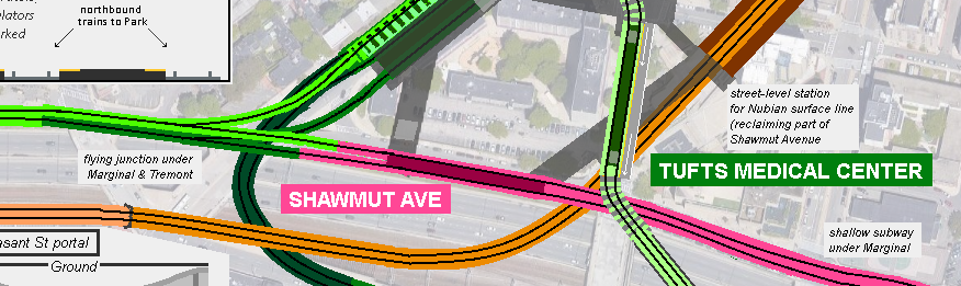
This design centers around a new LRT subway, connecting the current Huntington Subway through Back Bay station, continuing under Marginal Road, before turning north to connect to the Piers Transitway via South Station. The full details of this new subway are beyond the scope of this document, but in general is envisioned as a shallow-cut-and-cover subway hugging the edge of the Mass Pike, and sitting at roughly the same depth as the open-cut Mass Pike.
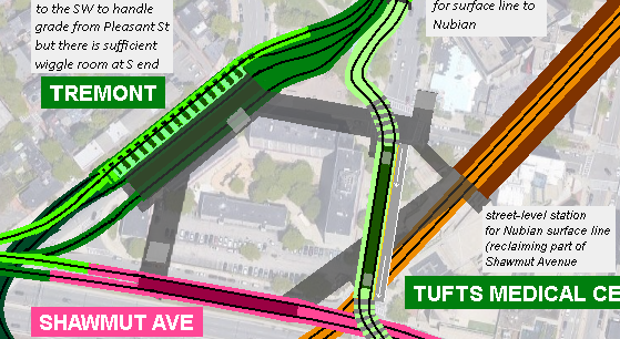
This design also accommodates two potential alternatives for a Green Line extension to Nubian. The first is the long-proposed surface line, which emerges at the Pleasant Street portal, uses a surface station at Tufts Medical Center before crossing the Mass Pike and assuming the route of the current SL4/SL5. The second alternative creates a subway line to Nubian via the I-93 corridor, The design of the junction is intended to accommodate both a surface line to Nubian, a subway line to Nubian, or both.
Finally, this design assumes that the Pleasant Street Portal and abandoned leg of the original Tremont Street Subway have been reactivated and restored for modern LRT service.
Surface Line to Nubian
As described here, I intend my designs to accommodate a future-proofed phased builds. My hope is that, given the right political environment, a Surface Line to Nubian could be built relatively quickly, so I have included a straightforward design for reopening the western bellmouth of the quad-tracked Pleasant Street Portal. This approach is similar to one put forward in 1978, see page 4 of this pamphlet.
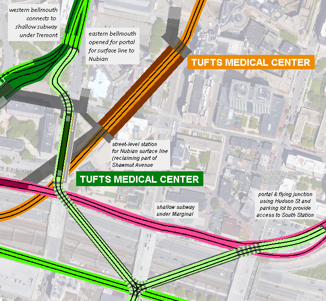
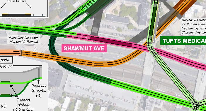
After reaching street level, the tracks turn south down Shawmut Ave. A 40-foot width of Shawmut Ave between Tremont/Oak and Marginal would be reclaimed for a surface station. This would require two parking lanes, leaving room for one travel auto lane and the existing bike lane.
An island platform spans the length of the block. The Tufts Medical Center concourse is expanded west under the intersection to connect to a headhouse on the surface platform. Designed properly, the surface platform could itself be behind fare control.
South of the station, the tracks proceed through a transit-priority signalized intersection before turning southeast to a diagonal bridge across the Pike. Alternatively, you could also take the other two legs of the triangle, and reclaim lanes on Marginal and Washington instead. The details of a surface-running line on Washington beyond this point are outside the scope of this document. Note that this design also supports a surface branch that re-enters the subway to South Station via a portal near Hudson St, supporting potential Park <> Seaport service.
Some portion of Eliot Norton Park would need to be reclaimed for the incline ROW. In general I have sought to minimize community impact, so I propose offsetting the loss of this greenspace by decking the Mass Pike between Washington and Shawmut and establishing a new park. If the surface line takes the hypotenuse through the park, I would want to look at including some sort of overpass or underpass to unify the halves of the park.
Subway Line to Nubian
In addition or instead of the Surface Line, this design also includes provisions for a Subway Line to Nubian. After departing Tremont station, the subway drops to (-3) in order to clear under both the Mass Pike (-1) as well as the Orange Line (somewhere between -2 and -1). From here, the subway runs alongside the Mass Pike for some distance.
Not pictured in the diagram is an option for a portal in the vicinity of Shawmut & Herald, as an alternate option for a surface line on Washington St (as depicted here). Illustrated instead is a subway that continues to run until Albany St/I-93, at which point it would turn southwest to reach Nubian via Boston University Medical Center. As with the Marginal Road Subway, this subway under Herald Street would be shallow cut-and-cover except (probably) for the portion crossing the Mass Pike.
Props to user themissinglink at ArchBoston who (I believe) was the first to suggest a pair of subways bracketing the Mass Pike.
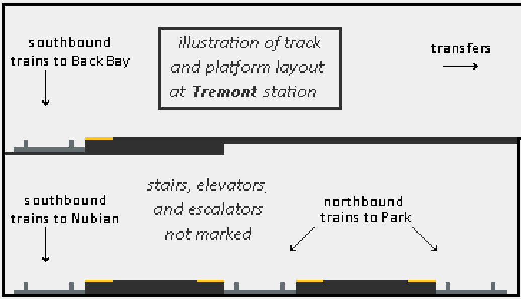
Tremont Station
Tremont is a dual level station, with three tracks on the lower level and one above. Nubian trains in both directions run on the lower level, alongside inbound trains from Back Bay to Park, while outbound trains to Back Bay run on the upper level.
Splitting Back Bay <> Park services across multiple levels is necessary to support the flying junction underneath the Marginal & Tremont intersection. At the flying junction, Back Bay-bound trains from both directions run in a subway at (-1), while diverging eastbound trains run one level below at (-2).
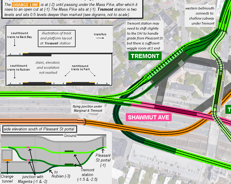
Unlike the rest of the proposal, Tremont station does not fit cleanly into the “Levels Below Ground” categories of (-1), (-2) etc. This is due to the wide range of tunnel depths to which the southern end of the station must be able to connect:
- outbound toward Back Bay: (-1)
- inbound from Back Bay: (-2)
- Nubian tunnel under Mass Pike + Orange Line: (-3)
At the same time, the northern end needs to be able to connect to the Pleasant Street Portal, which sits at (-1).
As a result, Tremont sits off-set by “half a level”: the upper track sits at (-1.5), while the lower tracks sit at (-2.5). This means that each tunnel only needs to handle a subsequent half-level of elevation change south of the station:
- outbound toward Back Bay: from (-1.5) to (-1)
- inbound from Back Bay: from (-2.5) to (-2)
- Nubian tunnel under Mass Pike + Orange Line: from (-2.5) to (-3)
I attempted to illustrate this using a side elevation diagram:
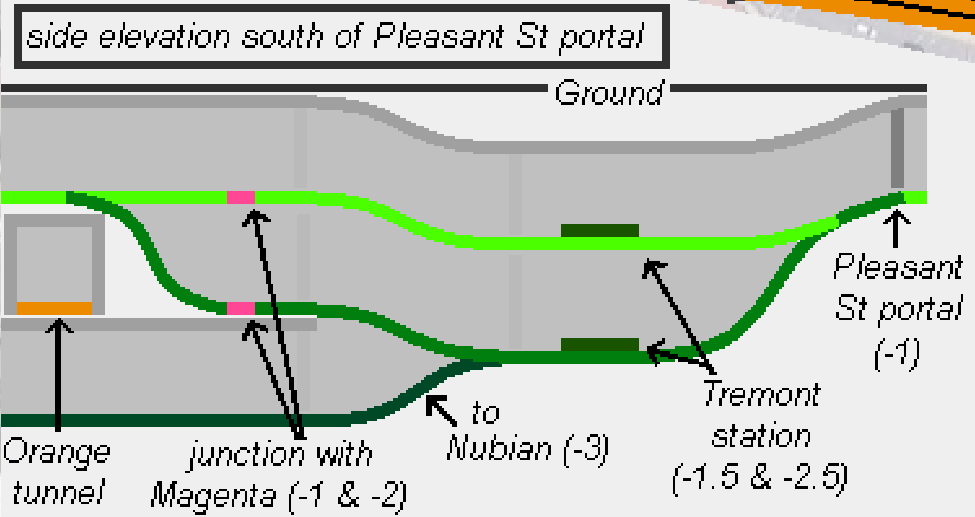
To accommodate these elevation changes at 6.9% grade, the following minimum horizontal distances are required:
- Pleasant Street Portal <> Tremont platform north end: 390 feet
- Track split under Marginal <> Tremont platform south end: 130 feet
- Nubian subway under Orange Line <> Tremont platform south end: 130 feet
In the diagram posted here, I have probably placed Tremont station itself every so slightly too far north to fit in that 390 feet, so it would probably need to be shifted to the southwest. However, there is ample room at the southern end — way more than 130 feet for both legs.
Tremont should have a pedestrian transfer tunnel under Tremont and Oak Streets to connect to the existing mezzanine at Tufts Medical Center, as well as a separate connection to Shawmut Ave station to the south. Transfer distance to the Orange Line would be roughly 700 feet, which would make it the longest transfer in the system, but this would be offset by closer transfers at Back Bay and Park/Downtown Crossing. (Surface trains would also have a much shorter transfer from the surface station on Shawmut Avenue.)
The more important transfer between Tremont and Shawmut Ave (to provide Green Line riders from Nubian and Park Street/points north a transfer to Seaport service) would only be about 200 feet, comparable to the outbound Orange -> Red transfer at Downtown Crossing (or “Winter” to “Washington” transfer, to use the old names). The transfer between the Orange Line’s Tufts Medical Center and Shawmut Ave would be closer to 400 feet — a bit shorter than the Winter Street Concourse.
Shawmut Ave Station
Shawmut Ave (renamable to “Shawmut” if an alternative name for the existing station on the Ashmont Branch can be found) serves “Magenta Line” trains running between the Seaport and Back Bay/Huntington via South Station.
Shawmut Ave‘s position is constrained by needing to pass over the Orange Line (-2) at the eastern end while needing to leave enough running room at the western end to reach the lower level of the flying junction, also at (-2).
This means the platform must sit at (-1), with 260 feet of horizontal distance between the edge of the platform and the track split under Marginal & Tremont. (For comparison, when measured diagonally, the Marginal & Tremont intersection itself is something like 270 feet, so there should be plenty of room.)
Placemaking and Naming
Is it altogether necessary to give different names to both of the new Green Line and Magenta Line stations? I think it’s debatable. For the purposes of this document, it’s useful to give them distinct names to differentiate between the various wings of what would be a sprawling complex of underground connections.
End to end, these interconnected stations span roughly 1100 feet. This is comparable to Haymarket <> North Station, Government Center <> Bowdoin, or Copley <> Back Bay, and is close to twice the distance between the Green and Orange platforms at Park/Downtown Crossing. On the other hand, it’s also about the same distance as State is end-to-end. So there’s precedent both for and against separate names.
Ultimately, I think a compromise could be to keep the Orange and surface Green stations as Tufts Medical Center and call both the Magenta and subway Green stations Tremont; they are closer to each other than to the Orange Line, and they both are meaningfully “at” Tremont Street.
(And yeah it’s a little confusing having a “Tremont” station on a subway that then continues under Tremont Street for another mile — but we already have worse with “Boylston“, and “Tremont” is a nice concise name that still has some meaningful sense of place.)
Acknowledgements
These ideas have been developed through lengthy collaboration with other contributors on ArchBoston, in particular in the “Green Line Reconfiguration” thread — now quite a lengthy thread, but a lot of the early versions of this idea were hashed out starting on page 40. An incomplete list of contributors I want to particularly acknowledge includes:
- DaveM
- F-Line to Dudley
- The EGE
- vanshnookenraggen
- Arlington
- themissinglink
- Charlie_mta
- 737900er
- Brattle Loop
- Teban54