
In this and the following post, I’ll go through the Blue Line West extension proposals that are commonly discussed these days.
Route 128 is well-accepted as the limit of what might be called “Metro Boston”, and typically is the outer limit of most transit proposals, and has been for decades, even before Route 128 was built. It sits 10 miles outside of downtown, which often is the limit of a rapid transit system’s reach, in cities around the world.
There is a much fuzzier “Inner Belt” that encircles what we might call “Greater Downtown”, encompassing not only the Financial District, but also the built-up areas of the Seaport, Back Bay, Longwood, and Kendall. This is definitely not a hard-and-fast delineation, but there is a subtle but noticeable shift in character for both the city and the transit network as you cross through the “inner belt”.
The name “Inner Belt” comes from a thankfully-cancelled proposed interstate highway (the remnants of which can be seen in the Inner Belt District and Inner Belt Road in Somerville). Its approximate path was also used in various plans for the Urban Ring. It sits approximately 3 miles outside of downtown, which is also a very typical location for circumferential rapid transit routes. The Inner Belt is roughly demarcated by a series of major transfer hubs: JFK/UMass, Nubian, Ruggles, Kenmore, Kendall or Central, Lechmere, Sullivan, and Maverick. Most of these are the first major transfer hubs outside of downtown on each route.
Any expansion of the Blue Line beyond Charles will come in phases, and the first phase will be about carving a path to the Inner Belt. The second phase will be about where to go after that. This post will go through the major “first phase” proposals in common circulation these days.
Blue to Kenmore
The Boylston Street Subway isn’t the only way to reach Kenmore. Once again, everything old is new again, and we find inspiration from an early 20th century proposal:

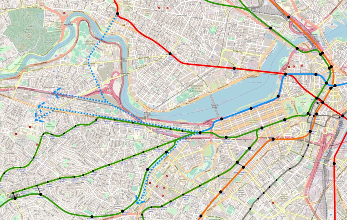
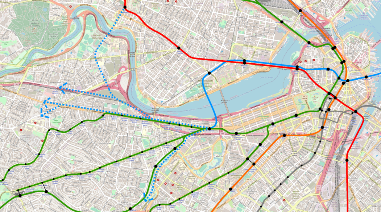
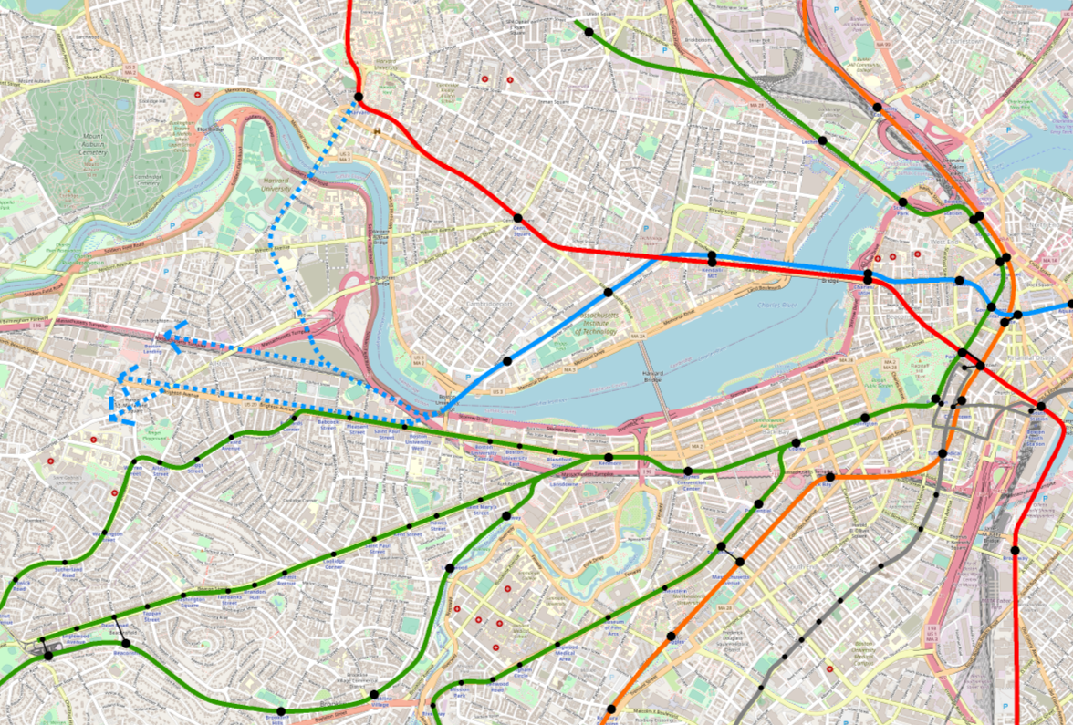
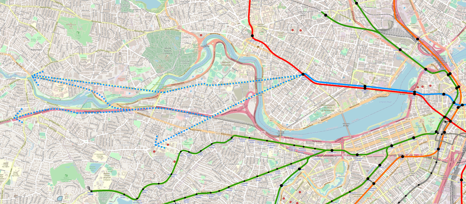
The proposed “Riverbank Subway” would have run from Park Street (upper level) under Chestnut Street to what is now Storrow Drive out to Kenmore. Note that at the time, the Boylston Street Subway did not exist — the Riverbank would’ve been the access point for trolleys from Watertown, Allston, and Brookline.
The modern incarnation of the Riverbank Subway proposal sees the Blue Line extended to Charles/MGH, down along the Esplanade and picking up Storrow out to Kenmore (with a quick jog over to Beacon after Mass Ave). In my opinion, you could see anywhere from 1 to 3 stations between Kenmore and Charles/MGH — definitely one at Mass Ave, and then perhaps one or two serving the far ends of Beacon Hill and/or Back Bay.
This is my preferred extension for the Blue Line. Kenmore is a major transfer hub and will become all the more so as the Urban Ring concept continues to be quietly implemented. An extension to Kenmore would then also provide relief to the Green Line.
While I believe this route also has the fewest problems of the alternatives, it does still present challenges. A subway under Storrow wouldn’t need to contend with too many utilities, and since it’s landfill there should be fewer 17th-century surprises underneath; however, that same landfill can be tricky to work with and would complicate construction.
Additionally, and I’ll discuss this further in my next post, there isn’t a clear “next step” beyond Kenmore for further extension. It’s not quite a dead-end, but it’s less clear than some of these other proposals would be.
Blue to Cambridge
Blue-to-Kenmore definitely does not enjoy unanimous support among enthusiasts like myself. The most common alternative is to send the Blue Line over to Cambridge — either directly under the Longfellow, or sometimes at an angle toward Binney Street. Once in Cambridge, there are a number of options. The most common I’ve seen is to turn west after Kendall to serve MIT and Cambridgeport. From there, you might cross back over to Kenmore, or head directly into Allston and beyond.
To be clear, I think these ideas have merit and should be seriously considered. Challenges to overcome include a subway under the Charles — and in fact in all likelihood, a second subway as well to cross back again –, the landfill around MIT (most of the Grand Junction would be hard to tunnel under, due to the landfill underneath), avoiding redundancy with the Red Line, and lack of a good clear “landing point” at the end (the equivalent of Kenmore, in the example above). Of these, the biggest to me is the need for two subway crossings under the Charles, which to be honest I really have no idea about the feasibility or cost of.
I also worry a bit about redundancy with the Red Line; Cambridgeport aside, Cambridge generally isn’t underserved by rapid transit, and I do believe there are equity and justice aspects to consider.
Blue-to-Cambridge alternatives can be distinguished by their subsequent destinations:
Kenmore
Crossing back over to Kenmore is tempting, given that Kenmore is and will become more of a “gravitational center” for transfers. But a pair of lengthy river crossings seems hard to justify. If Kenmore is your destination for the extension, I think the Riverbank option makes more sense.
BU Bridge
Carrying on straight to the BU Bridge makes for a more direct route. However, missing Kenmore is a significant loss. Moreover, all future alignments from BU Bridge could be accessed via a Riverbank subway to Kenmore. What you get uniquely from this alignment is HRT service to Cambridgeport. Given that LRT service is much more achievable for Cambridgeport and would likely satisfy the need there effectively, this seems like a less efficient alternative.
Central
Doubling up to Central Square and then heading west has, on paper, some real strengths. Unlike Kendall, Central is a legitimate feeder bus transfer hub of its own right. From Central, further extensions appear ripe (on paper) to Watertown, Allston, and/or Brighton, following existing higher-ridership bus routes, on near-straightaway alignments.
The strongest argument in favor of an extension to Central Square is the access to Watertown. Access to Watertown via the Mass Pike ROW is shared between the Central Square alignment, the BU Bridge alignment, and the Kenmore alignment, but access via Western Ave & Arsenal St (the route of the 70 bus) is unique to the Central Square alignment.
Doubling up all the way to Harvard yields a similar set of pros and cons as Central does, although Harvard makes it much more difficult to continue on to Allston and Brighton.
Doubling the Red Line
Doubling along the Red Line in general is tempting, as a way to increase capacity. But I think this is a situation where the details of the build have outsized importance. In New York City, 4-track subways are mostly constructed on a single level, with shared platforms between services going in the same direction; if you are heading uptown, you go to the uptown platform and have the benefit of choosing the express vs local service based on which train arrives first.
If you aren’t able to unify services on single platforms, you run into drawbacks very quickly that will severely undercut your hoped-for capacity boost. For example, I’ve seen proposals that place a Blue Line station at Kendall off-set to the north, near the Volpe building. This may be a useful footprint in which to build a station, but it means that the Blue and Red Line platforms will be some distance apart.
Distanced platforms means that riders will need to commit to a line decision very early in the boarding process. This means that agnostic riders — those destined for Charles/MGH, Park, Government Center, State, DTX — will still have to pick a line, even though either one will work for them. They won’t have that New York-style “stand on the platform and grab the first train to arrive” option. Given that Red will eventually have 3-min headways and Blue (as far as I know) will have 5-min, you also won’t see an even split among agnostic riders, as some will prefer the higher-frequency service – the Blue Line will probably get very few agnostic riders, and instead will be only picking up riders who were destined for the Blue Line anyway.
It’s true that doing so would still relieve crowding on the Red Line, but it still is targeting only a particular subset of riders. Additionally, depending on how far the Blue Line doubles (Kendall, Central, Harvard), you’ll still need to contend with riders transferring from the Red Line (e.g. from Davis) to the Blue Line – where will they make the jump from Red to Blue (and therefore where could we expect crowding relief to start)? Charles/MGH looks like it will be very well-designed for easy transfers, so if Charles provides a shorter walk than Kendall does, many riders will continue to stay on the crowded Red Line, even though in theory the Blue is available.
I should also note that doubling up the Red Line would entail significantly more complicated tunneling than other proposals would.
There are other ways to address capacity on the Red Line. Increasing headways will add about 50% additional capacity. Extending the Green Line to Porter will siphon off both downtown and Longwood/Back Bay commuters, looking for a faster and/or one-seat ride to their destination. Providing circumferential service – for example LRT on the Grand Junction, or a Green Line spur to Harvard – will also reduce the number of riders needing to go downtown. Doubling up with the Blue Line is not the only option.
A verdict?
As mentioned above, I believe a first phase extension to Kenmore is the stronger option. I will discuss my reasoning in further detail in the final post in this series. That being said, I firmly believe that both alternatives present benefits and drawbacks, and neither presents a perfect solution.
Both alignments require study. As I laid out in previous posts, we’re in uncharted waters here. No heavy rail service has ever existed along the trajectory we are discussing, making this corridor almost unique among transit expansion proposals in Boston. So I absolutely want to be clear that a firm verdict is both impossible and undesirable at this stage.
What I will state with greater confidence is what options are created and eliminated by each of these alternatives. And what I will go into further depth on is how these alternatives reflect larger systemic choices we need to make as we envision the T’s future in the third millennium. This isn’t just about job growth in Kendall, or passenger transfers at Kenmore: it’s much bigger than that.
In the next post, I’ll talk about where the Blue Line might go after a Phase 1 extension.