
In December of last year, I submitted two maps to the Boston Public Library’s Norman B. Leventhal Map & Education Center’s Transportation Dreams contest. The first is entitled “Project Electric Sheep,” and the second is “Project Gold Line.”
I’m a firm believer in dual creative processes — “campaign in poetry, govern in prose,” “write drunk, edit sober” (in the metaphorical sense), creation and refinement. These two maps present a similar duality: one is wider-ranging in its creativity; the other is a refinement into a focused proposal.
I do want to emphasize that, even on the creative map, all proposals are grounded in examinations of feasibility, cost-effectiveness, and efficiency. These are indeed “transportation dreams”, but they absolutely could be realities.
(I am told these and the other submissions will be on display at the BPL through the end of February!)
“Project Electric Sheep” — a feasible yet fun “crayon map”
This is the statement accompanying my submission:
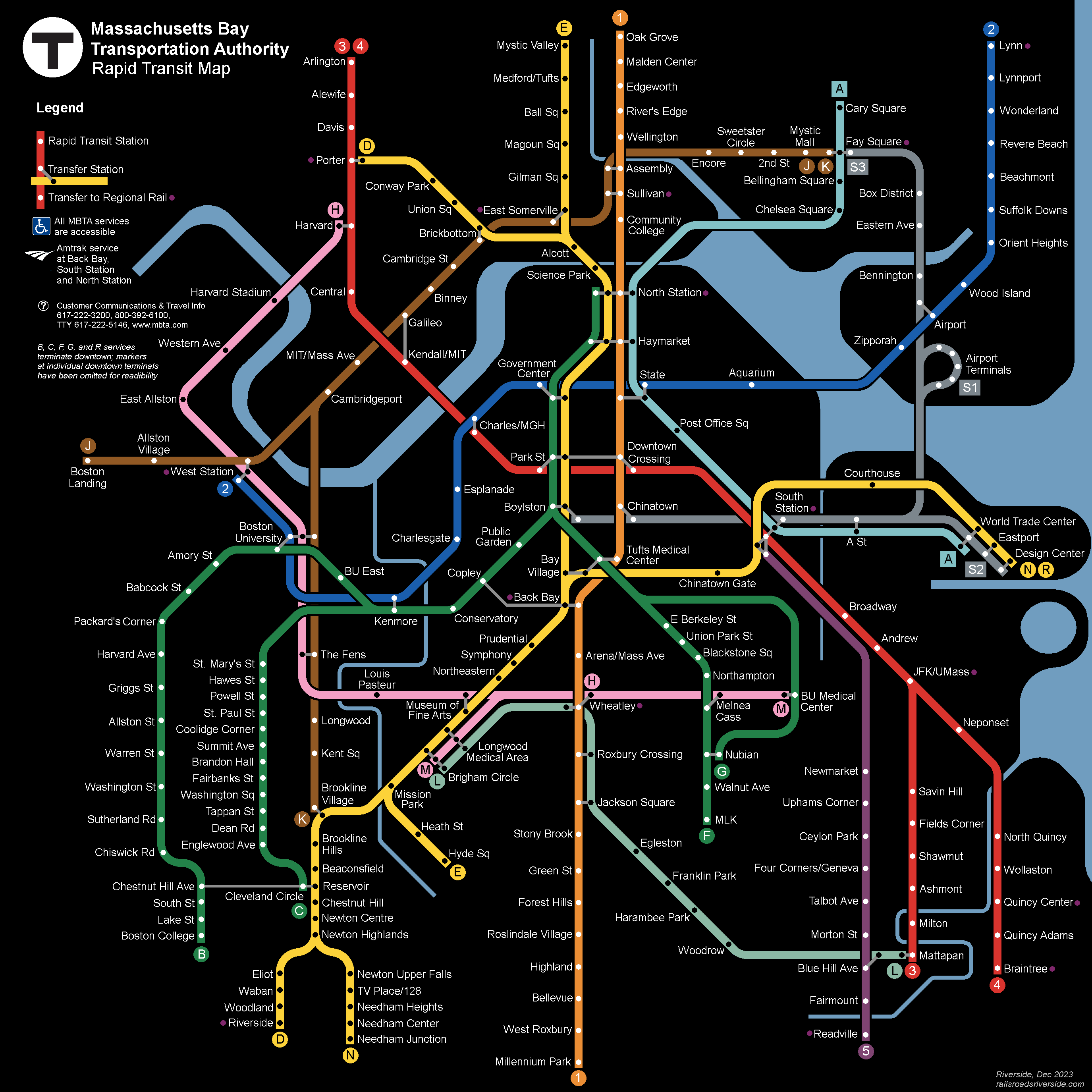
This map has been perhaps a decade or more in the making. Drawing heavily on discussions I’ve participated in on ArchBoston, I have sought to generate a vision for Boston transit that is both inspiring and feasible.
This design adds over 44 miles of rail to the T’s existing network, only about 9 miles of which would require new tunneling. By focusing on existing infrastructure, extant ROWs, and opportunities for low-cost construction (such as wide streets and areas with well-mapped geologies), we can achieve a radical increase in transit access across the region.
My proposals are built on data from a range of sources, including:
- ridership data from the Blue Book portal and Better Bus Profiles,
- employment and demographic data from the US Census (especially On The Map), Go Boston 2030, and other sources,
- a slew of project studies dating back over 100 years,
- the TCRP’s Track Design Handbook for Light Rail Transit,
- geospatial data from Google Maps, OpenStreetMap, and other sources (particularly old Bromley Atlases),
- USGS geological data,
- newspaper clippings sourced through Wikipedia (with grateful thanks to the tireless contributors there), and
- numerous historical works by Frank Cheney, Anthony Sammarco, Bradley Clarke, O.R. Cummings, George Chiasson, Jr, Jonathan Belcher, Thomas Humphrey and others
I have also drawn on the qualitative experiences of myself and other T riders.
This map would not have been possible without the years of collaborative discussion at ArchBoston. Much of my thought process in developing this map is documented there, and some proposals are also documented on my website (ever a work in progress).
A small number of stations have been renamed on this map, for ease of wayfinding and to celebrate a fuller array of figures from Boston’s rich history.
This diagram includes the “Gold Line,” an articulation of a long-discussed idea on ArchBoston, which is presented in greater detail in my second submission (below) and here on my website.
(The submitted map had the Bronze Line J service terminating at West Station rather than Boston Landing. Further details in the appendix. The submitted map also had the labels for Edgeworth, River’s Edge, and Wellington in incorrect order, which I have fixed here.)
This diagram is, in some ways, meant to be “fun” (in a way that crayon maps are supposed to be). There isn’t a specific date tied to this map, and it neither represents a “preferred build” nor a “full build” nor a “must build”. Rather, it’s a vision of one possible future.
Project Gold Line
This is the statement accompanying my submission:
Like my other submission, this map has also been long in the making.
Over the last decade, an ongoing discussion on ArchBoston has examined ways to remake the Green Line into a better version of itself. These discussions have been wide-ranging, at times ruthless in pragmatism, and equally unbound in imagination.
Only in the last couple of years has a consensus emerged on certain key pieces of this “Green Line Reconfiguration”. I myself have struggled to find a way to articulate the possibilities afforded by these (relatively mundane and unflashy) key pieces.
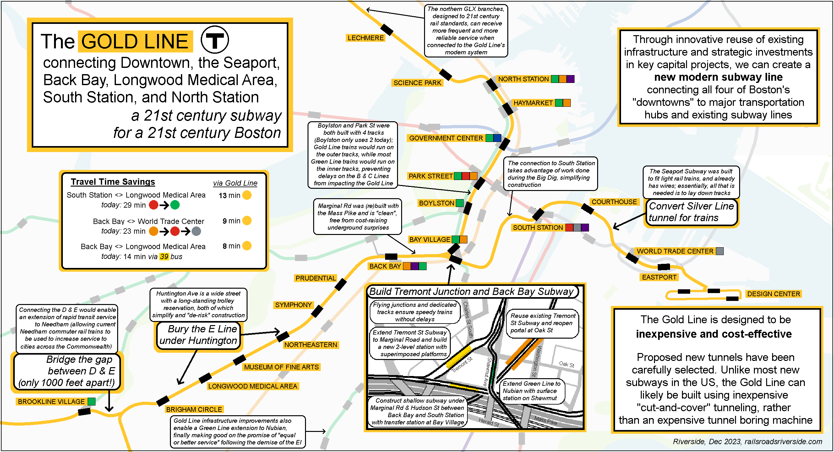
Which brings us to: the Gold Line. The “Gold Line” concept seeks to pithily capture the key projects needed to unlock the system’s full potential:
- Reroute the E Line via Back Bay to utilize the unused Tremont St Subway
- Extend the E Line’s subway west down Huntington, at least to Brigham Circle
- Construct a short subway to South Station and run trains through the Silver Line tunnel, linking the Seaport, Downtown, Back Bay, and Longwood
There are additional components beyond these, including connecting the D and E Lines to create a full-length rapid transit line, as well as extending the Green Line to Nubian Square, but the three investments listed above would, in tandem, be transformative.
Particular data sources include:
- ridership data from the Blue Book portal and Better Bus Profiles,
- employment and demographic data from the US Census (especially On The Map), Go Boston 2030, and other sources,
- relevant project studies, particularly the never-built Silver Line Phase 3 (such as its DEIS),
- the TCRP’s Track Design Handbook for Light Rail Transit,
- geospatial data from Google Maps, OpenStreetMap, and other sources (particularly old Bromley Atlases), and
- USGS geological data
Beyond ArchBoston, some of these proposals are also documented on my website (ever a work in progress).
Additional details on the Gold Line concept are available here on my website.
~~~
Teban54Transit also submitted a map to Transportation Dreams detailing the Green Line Reconfiguration concept. He and I corresponded while creating our maps and we decided to intentionally pursue different approaches. My Gold Line map focuses on a set of core components, while Project Electric Sheep shows the Gold Line in a systemwide context with other extensions, such as a Bronze Line through Kendall; his map falls in between, showing a larger and more detailed view of the expansions to the existing Green Line that become possible through the Green Line Reconfiguration. Our maps have some differences, which intentionally demonstrates the flexibility of the improvements we propose.