I redesigned the Framingham/Worcester schedule

In an effort to provide more frequent service to the three stations in Newton, I’ve developed a rework of the Framingham/Worcester Line schedule; there are lots of open questions that I can’t answer at this point, but from what information I do have, I believe the rework would be feasible, and would in fact improve service for the majority of riders on the line.

I propose switching from a “zonal express” model to a “skip-stop” model; this would keep travel times under control, while enabling trains to stop more frequently within the higher density suburb of Newton. Based on my analysis, this would require no additional rolling stock, and possibly may be able to use one fewer train than today. Operational expenses would potentially increase mildly, but no capital expenditures should be required to enable this proposed schedule, aside from the already-underway Worcester Union Station platform project.

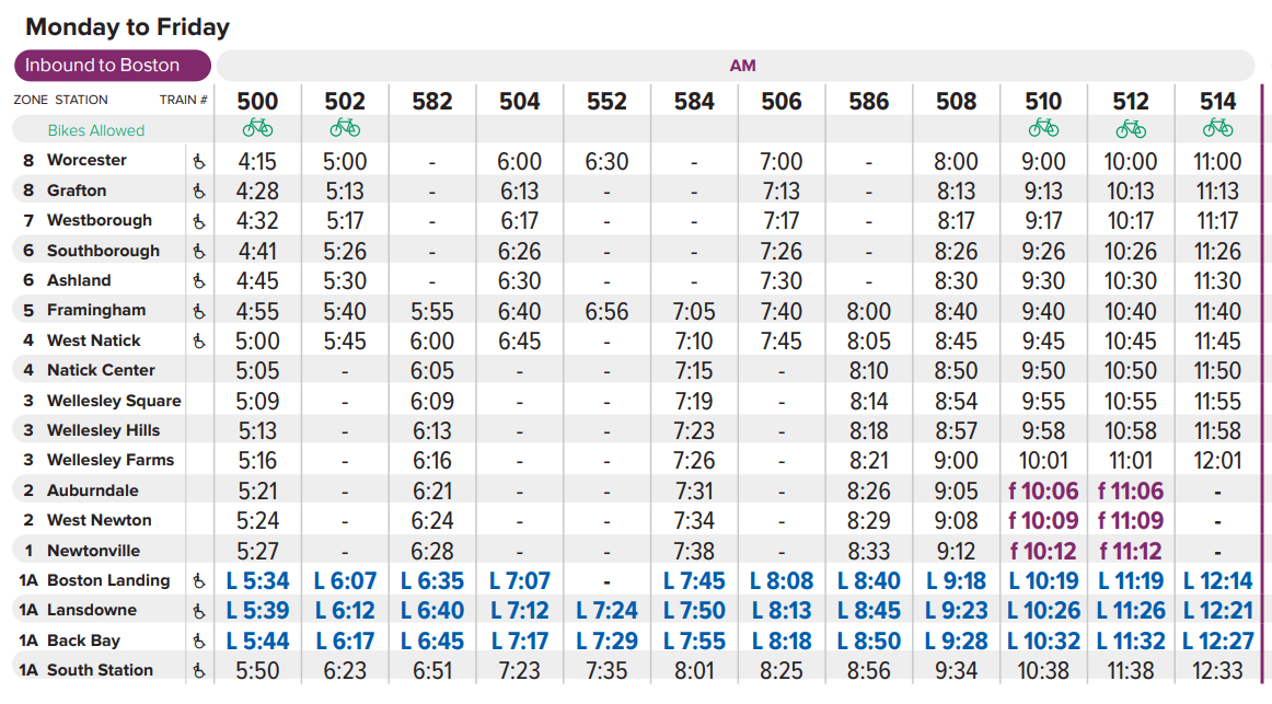
Here is a tentative draft of my proposed schedule; background, methodology, and details described below.
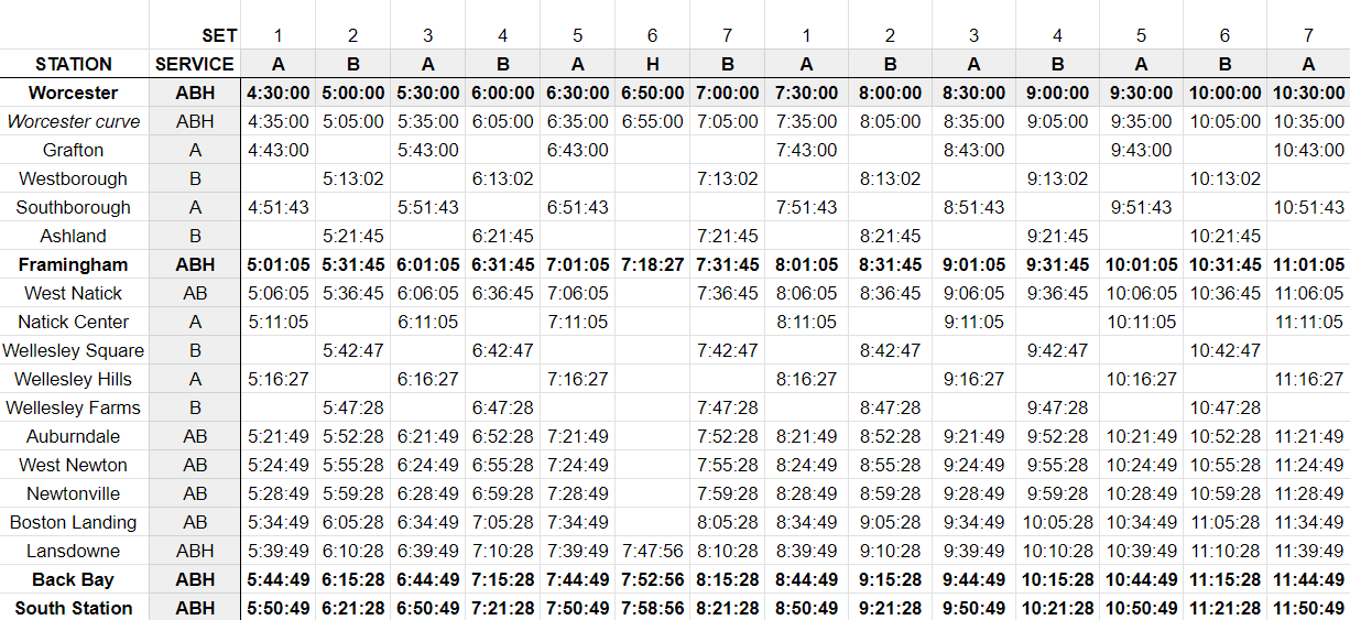
proposed skip-stop schedule

Background and current conditions

The Framingham/Worcester Line is a difficult line to run. It presents multiple challenges:

  • It is long: about 43 miles as the crow flies from Worcester to Boston – comparable to the Providence Line (measured from Providence) 
  • But, unlike the Providence Line, which has lengthy straightaway segments, the Worcester Line has curves aplenty, including a pair of modestly tight S-curves as the rails wind their way into Worcester
  • It has lots of stops: 15 between Worcester and Back Bay (compared to 8 on the Providence Line)
  • It has operational constraints due to the locations of platforms (see this post by Dave Perry explaining the track numbers, and detailing some of the operational constraints):
    • “The Newtons” (Newtonville, West Newton, Auburndale) currently have platforms only on Track 2
    • At Wellesley Hills and West Natick, the parking lots are located next to the platform on Track 2; the platform for Track 1 is only accessible via an at-grade crossing across the tracks
      • The T therefore runs all peak direction trains on Track 2 through these stations to avoid having large crowds of commuters crossing live tracks
    • Worcester’s platform is currently only accessible from Track 1, though the T is building a center platform to allow access from both tracks and enable more than one train to occupy the station at once

The T addresses these challenges through two methods.

First, peak direction trains are divided into “Worcester expresses” and “Framingham locals”, where hourly trains depart from Worcester and make all stops to West Natick before expressing to Boston Landing, while offset hourly trains depart from Framingham and make all local stops. A single “Heart to Hub” (or “H2H”) train leaves Worcester and runs express to Framingham and then express again to Lansdowne, to provide Worcester commuters an option that arrives within Boston’s borders in less than an hour. (Journey time to South Station is 1h5m.)
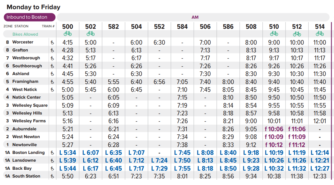
current schedule

Second, to accommodate the single platforms at the Newtons, as well as the pedestrian-unfriendly conditions at Wellesley Hills and West Natick, the T runs all peak-direction trains on Track 2 between Framingham and Boston. In essence, Track 2 acts as the “inbound” track in the morning and transforms into the “outbound” track in the afternoon. 

Reaching toward frequent Regional Rail service for the Newtons

This project began with an effort to identify ways to increase the frequency of service to the Newtons, which sit in modestly walkable neighborhoods of similar density to the villages served by the Green Line to the south, but which only see hourly service during rush hour. 
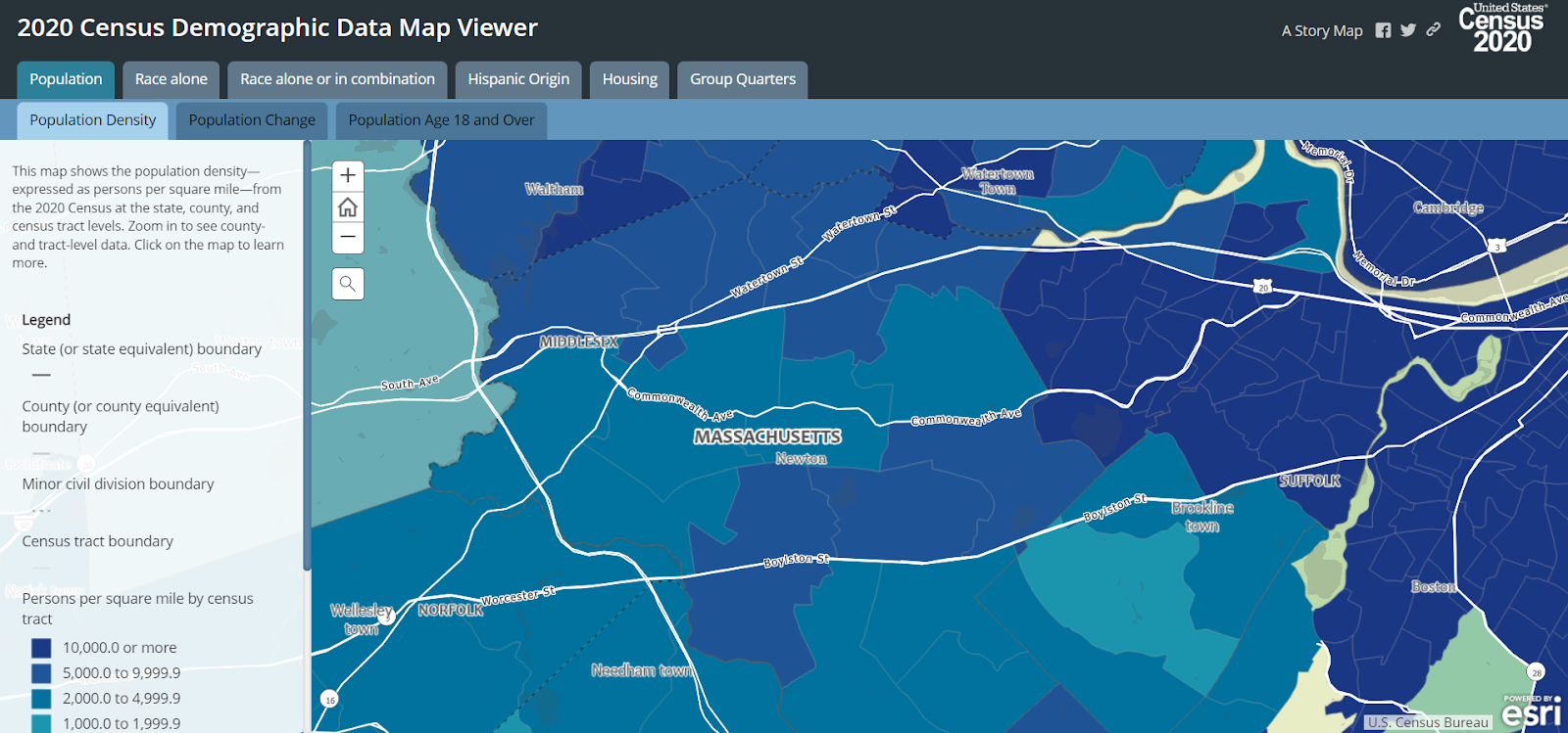
density map of Newton along the Worcester Line,
from https://mtgis-portal.geo.census.gov/arcgis/apps/MapSeries/index.html?appid=2566121a73de463995ed2b2fd7ff6eb7

What’s more, there are trains running through these stations during rush hour, roughly every thirty minutes; the problem is that those Worcester expresses run non-stop in order to keep travel times down for the longer commutes.

If only there were a way for those Worcester expresses to stop at the Newtons without impacting the commute times for riders west of Framingham.

Then something occurred to me: what about a skip-stop service?

Skip-Stop Services

For those unfamiliar, skip-stop services are a technique to speed up journeys on lengthy routes by dividing trainsets into two groups, with consecutive stations alternating between the two groups, punctuated by periodic “all trains” stops served by both groups.

Skip-stop service was used throughout the 20th century on major American subways. New York, Chicago, and Philadelphia all used skip-stop patterns to varying extents, though today I believe only one set of services remains in use (the J/Z in New York). They have fallen out of favor in part because they make the system more confusing for new riders and because (in my opinion) the time savings on a rapid transit system simply aren’t particularly large. And particularly for “local” journeys on a subway line – e.g. in New York if you’re only looking to go 30 blocks, about 3 stops – skip-stop service is much more disruptive, requiring a transfer.

Skip-stop service potentially can be effective, but it needs to be on a corridor where there are both significant time-savings and minimal intra-corridor (“local”) journeys.

So, I wondered, could skip-stop service patterns generate enough time-savings to “free up” space in the schedule for Worcester expresses to stop at the Newtons?

The answer, I believe, is yes.

Generating a schedule

To test different service patterns, I built an interactive spreadsheet that allows you to

  1. Assign stations to different service groups (e.g. “A” or “B”)
  2. Set each train’s departure times from Worcester
  3. Assign each train to one of the service groups

And from there, the spreadsheet will auto-generate the schedule for each train. Critically, this spreadsheet takes into account the time-savings from skipping a stop. (It also takes into account the significant speed restriction due to the curve in eastern Worcester, which will slow trains regardless of whether they make the subsequent stop in Grafton.)

To confirm the accuracy of the spreadsheet’s predictions, I provided it with the service patterns and Worcester origination times for the current schedule. (One major limitation of the spreadsheet is that it only supports calculations for trains originating in Worcester, so I used a hypothetical Worcester departure time that calculated a Framingham departure time matching the current schedule.)

The schedule predicted by the spreadsheet matches the current schedule with high accuracy, in most cases deviating from the current schedule by less than 60 seconds. (The deviations are slightly higher for the H2H service, but my spreadsheet overestimates travel times, and only by 3 or 4 minutes.) So, I am modestly confident in the accuracy of my model’s predictions.
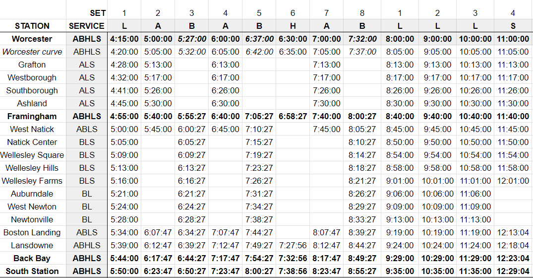
current schedule, as inferred by my model, based on inputted stopping patterns and departure times from Worcester
actual current schedule

Presenting: Half-hourly skip-stop service from Worcester

By moving the stops between Worcester and Framingham, and the stops between West Natick and Auburndale, into a skip-stop pattern, we get the following schedule.
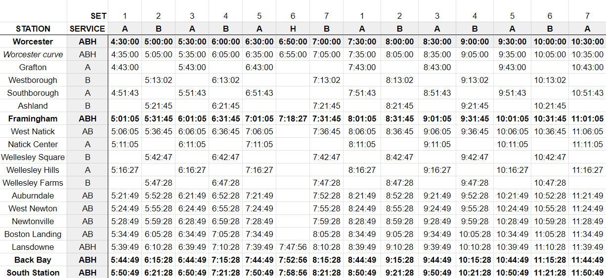
proposed skip-stop schedule

This schedule achieves the primary objective: providing more frequent (half-hourly) peak direction service to the Newtons, without requiring additional rolling stock or capital improvements (beyond the new platform at Worcester, currently under construction). 

This schedule provides additional benefits.

Benefits to frequencies and journey times

Service from Worcester doubles to half-hour headways. Additionally, coming from Worcester the travel times are equal (or slightly better) to today’s Worcester expresses, at about 1h21m (compared to today’s 1h23m). 

Service from Framingham becomes clock-facing with half-hour headways. There is a resulting trade-off: the current schedule offers hourly 43 min journeys in addition to hourly 56 min journeys (offset from each other by about 15 minutes); my proposed schedule sees consistent journey times of 50 min, which is a bit slower for commuters who are used to the current Worcester expresses. On the other hand, my proposal eliminates the 45 min gap between trains, significantly improving commute flexibility. 

(And, as I’ll discuss below, it may be possible to run two H2H trains, which would provide an additional express option for Framingham commuters.)

Journey times either remain constant (within 3 minutes) or improve from most stations. Ashland and West Natick see a similar tradeoff to Framingham – journey times increase by 6-7 minutes; in West Natick’s case, that is off-set by a doubling of frequency.

Benefits to rolling stock efficiency

Finally, this schedule requires no additional trainsets, and may in fact require fewer trains than the current schedule. By my reckoning, the current schedule requires about 8 or 9 trains, possibly with one or two intermingled with other lines. My schedule requires 8 trains, which can be reduced to 7 if most reverse services make limited stops (which would be commensurate with the reverse peak demand, which, at least in 2018, was focused on commutes from Boston to Framingham and to Worcester, and to a lesser extent, Natick.)

If even one trainset is freed up, this opens the door to several possibilities.

Additional “Heart-to-Hub” service

First, the newly available sets can be repurposed to provide additional service on the Framingham/Worcester Line. For example, one of those extra sets could be used to add an additional “Heart-to-Hub” express service from Worcester:
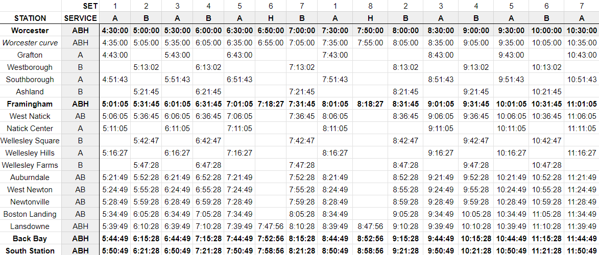
potential skip-stop schedule with an additional H2H service

(In the not-too-distant future, I would love to see a second H2H slot instead filled by a MassDOT service from Springfield, ideally using rolling stock that has been sourced externally.)

30-min headways on the Fairmount Line

Possibly most importantly, even just freeing up a single extra set would allow the Fairmount Line to increase from 45-minute headways to clockfacing 30-min headways, which would be a big step forward in getting the Fairmount Line closer and closer to rapid transit service. 

half-hourly Fairmount service, requiring only one additional trainset

Higher frequencies to the Newtons

Finally, while it would definitely require at least one additional trainset relative to today, I sketched out a schedule that would add a third stopping pattern, originating at Framingham, expressing to Auburndale and making all stops thereafter, providing 3 tph to Framingham, and providing clockfacing 20-minute headways to the Newtons. This schedule would (I believe) require 8 sets operating from Worcester, and two additional sets operating from Framingham.
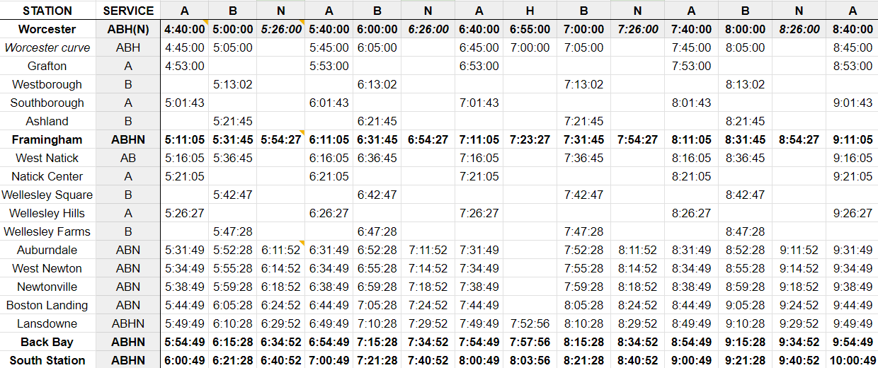
schedule concept for service to the Newtons every 20 min

(The schedule generator I built requires trips to “originate” in Worcester, so I’ve included hypothetical departure times from Worcester in italics – trains with the N service pattern would in reality originate at Framingham.)

Overall, I would use the extra trainset(s) to reduce Fairmount headways to 30 minutes as a first priority, and add a second H2H service as a second priority. I don’t see an urgent need to provide 20 minute headways to the Newtons – I offer it more as a fun bit of imagination. 

Conclusion

To review, I believe using a skip-stop service pattern originating from Worcester will:

  • Provide half-hourly service from Worcester at the same travel time as today
  • Provide half-hourly service in the peak direction to the three stations in Newton
  • Provide near clock-facing service from Framingham at a consistent journey time comparable to today
  • Maintain existing frequencies for all other stations
  • Maintain equal or faster journey times for most stations
  • Require no additional rolling stock
  • Potentially free up existing rolling stock to raise frequencies on the Fairmount Line to 30 min

To me, that sounds like a palpable improvement in service — and something I believe would be well worth the MBTA’s consideration.

Mapping the Bus Network Redesign: Somerville’s Buses, Present and Proposed

Some of the earliest public feedback on the MBTA’s Bus Network Redesign (mapped in a previous post) came from residents of Somerville (and, to a lesser extent, Cambridge) who were – almost unanimously – unhappy with the proposals. 

City Councilor Judy Pineda Neufeld gave lengthy feedback, praising the increases in frequency, and raising serious concerns for riders from West Somerville (in particular Clarendon Hill), and those trying to reach Union Square and the nearby Market Basket. Others seconded the concern about lack of access to Market Basket, as well as poor connectivity to GLX, some suggested that GLX was mistakenly being viewed as a substitute for current bus service, and numerous people noted that a lot of ideas in the Redesign were pretty good, but that Somerville appeared to draw the proverbial short straw.

Based on my anecdotal observation on social media platforms, it appears that initial reaction from other communities has been more muted; this may change in the coming weeks with the further feedback sessions the T has planned. But still, I thought it was interesting that there was such an immediate and resounding response by comparison from Somerville.

I don’t envy the Redesigners their task with the Northwest Quadrant um, Sextant (?). Uniquely, they had to design for a system that doesn’t exist yet: GLX will be a seismic shift in transit access for Somerville, and while some of its effects are predictable, some are not. That’s a pretty big wildcard to toss into the mix.

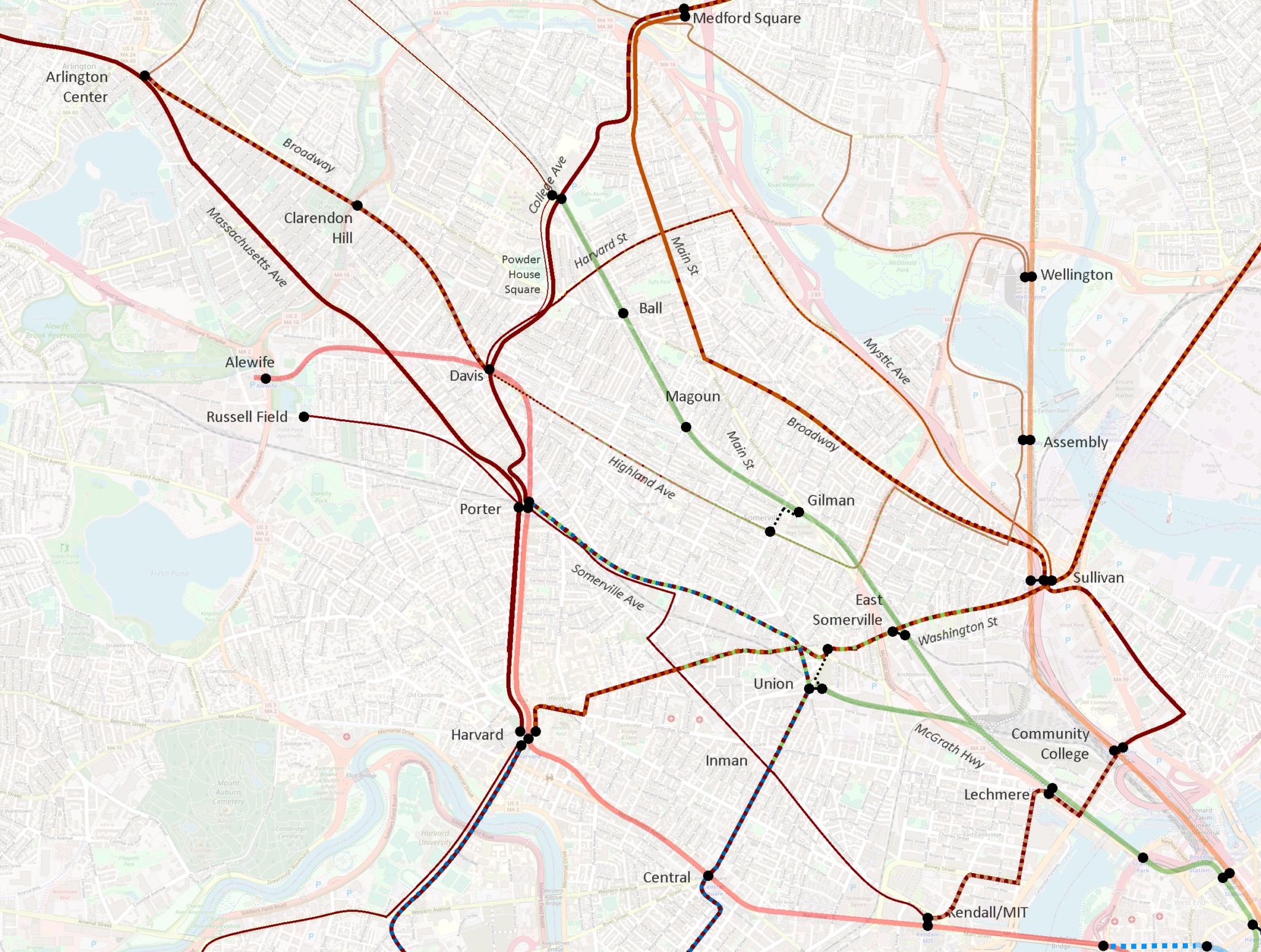
The early signs suggest the Redesigners missed the mark, at least from the perspective of the community. I wanted to dig in to this and – of course – wanted to make a map to add to the conversation. I believe that I have been able to piece together a visualization that offers context and some explanation for this initial pushback; based on these, I have also generated some modest suggestions for revisions to the Redesign.

Further details are below, but the core of my suggestion is “swapping” the proposed T39 and proposed 90; this provides an increase in service to most riders, but is a more conservative change that does not disrupt existing travel patterns. This extension can be “paid for” by a dramatic shortening of the proposed 87 to its core service area, a reroute of the 90 to a shorter well-established corridor, and the use of a lower-freq crosstown route and a shuttle service to address connectivity gaps to Sullivan and Assembly.

The Map

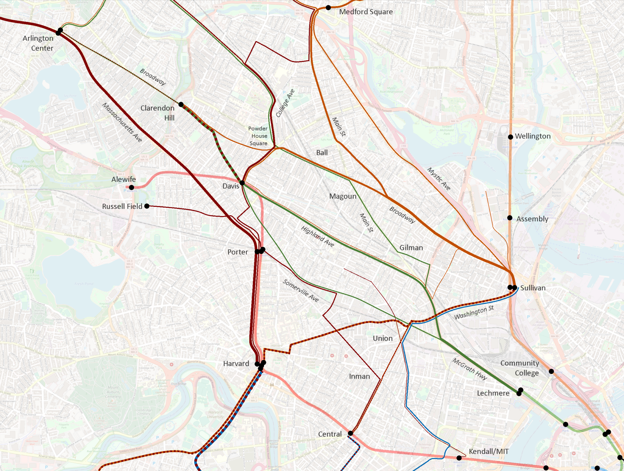
I had two goals with this map: visualize frequency, and visualize potential destinations. I chose these goals because they reflected themes I saw in the initial feedback: frustration at multiple transfers (meaning, need for direct access to a larger number of destinations), and loss of service, particularly for lower-income residents (which I believe in some cases was a result of the Redesign’s shift away from “mid-low frequency” routes – think 45-min peak headways, that kind of thing).

Line color denotes reachable destinations. This system isn’t perfect, but I think captured some key dynamics. 

  • Dark red lines reach Red Line stations 
  • Dark orange lines reach Sullivan Square specifically, and light orange lines serve other Orange Line stations 
  • Dark green lines reach Lechmere 
  • Dark blue lines serve Longwood Medical Area

Some lines see multiple colors, meaning a rider might board a bus for multiple destinations; a good example of this is the 87 & 88 north of Davis, where a rider might board destined for Davis or for Lechmere.

Line width indicates frequency. 

  • The thinnest lines have peak headways more than 30 minutes
    • such as the 85 or 90
  • The next size up, forming a large swath of the network, denotes headways between 15 and 30 minutes at peak, including 
    • the 95 along Mystic Ave, 
    • the 87 along Somerville Ave,
    • the 83 along Somerville Ave and Beacon St
  • Thick lines indicate peak headways of 15 minutes or better – matching the target for the Redesign’s frequent network, and including major corridors along
    • Broadway 
    • Highland Ave, 
    • College Ave, 
    • Washington St
  • The thickest lines – matching the width of the rapid transit lines – see peak headways of less than 10 minutes, including 
    • the 77, 
    • the cumulative 87 & 88 between Davis and Clarendon Hill, 
    • the 101 & 89 on Broadway running into Sullivan

Here’s a version of the current system only showing routes that see 15-min peak headways or better.

Here we see six distinct corridors emerge:

  • Medford Square (and Malden) – Main St – Broadway – Sullivan
  • Powder House Square – Broadway – Sullivan
  • College Ave – Powder House Square – Davis
  • Clarendon Hill – Davis – Highland Ave – Lechmere
  • Arlington Center – Porter – Harvard
  • Sullivan – Union – Harvard – Allston/Brighton and Reservoir

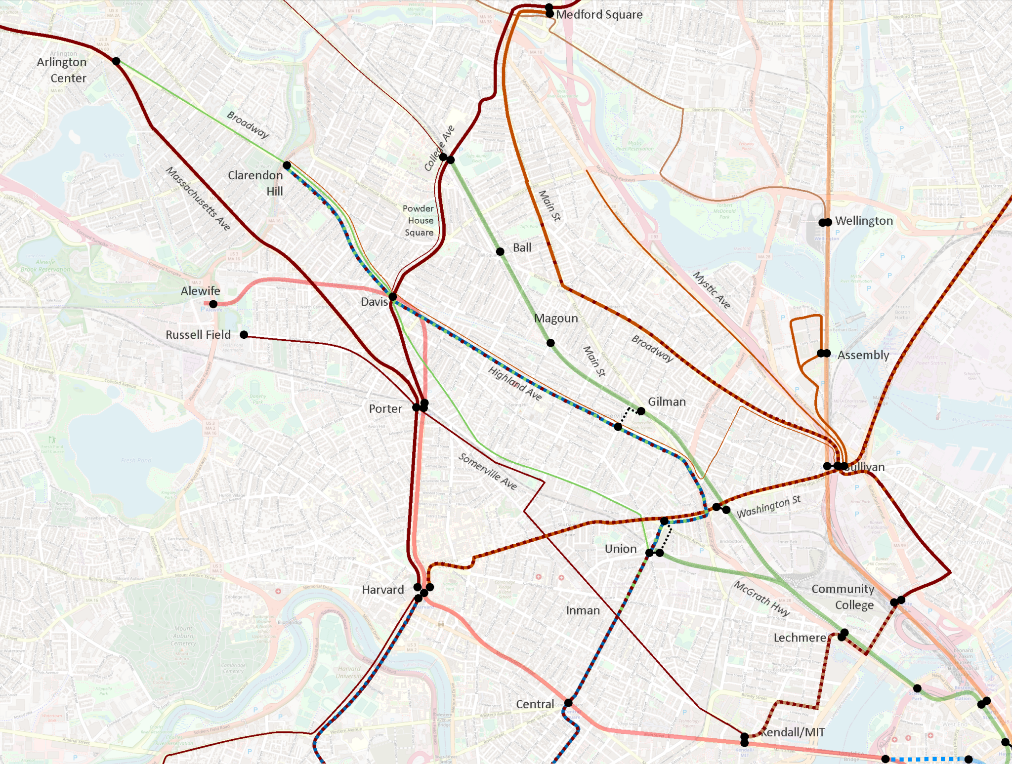
I then created a map using the same design language to visualize the Redesign proposal.

(I recommend opening the “before” and “after” images in separate tabs, and then switching between them to hone in on the differences. I tried creating a GIF, but was unsatisfied with the results.)

Impact to current high-freq corridors

Let’s first review the impact to the current high-freq corridors:

  • Medford Square (and Malden) – Main St – Broadway – Sullivan
    • Largely intact
    • Goes near but does not provide transfer to GLX at Ball Sq
    • Extended beyond Sullivan to provide a (long) one-seat ride to Lechmere and Kendall
  • Powder House Square – Broadway – Sullivan
    • Eliminated
    • Moreover, this route is actually composed of a pair of branching routes:
      • a mid-freq route to Davis
      • a low-freq route direct to Clarendon Hill
    • Davis and Clarendon Hill lose direct service to Ball Sq GLX and Broadway
    • Davis and Clarendon Hill maintain roundabout access to Sullivan via Mystic Ave, an increase of 0.5 miles
  • College Ave – Powder House Square – Davis
    • Intact and strengthened
    • Newly anchored at north by Medford/Tufts GLX and extension to Medford Sq
    • Worth noting that the twice-hourly one-seat ride beyond Davis to Porter and Harvard is eliminated
  • Clarendon Hill – Davis – Highland Ave – Lechmere
    • Significantly reduced, and partially eliminated
    • Clarendon Hill – Davis gets a pair of the Redesign’s “30-min-or-better” routes, which could approximate 15-min headways, but still does not meet the current service’s average sub-10-min frequencies
    • Highland Ave drops into the Redesign’s “30-min-or-better” routes, but does not connect to Lechmere, or to Union GLX, or even to Gilman GLX (though it comes close), but instead is rerouted over toward Sullivan… which it doesn’t actually reach, instead ultimately diverting to Assembly
  • Arlington Center – Porter – Harvard
    • Intact
  • Sullivan – Union – Harvard – Allston/Brighton and Reservoir
    • Partially eliminated
    • Sullivan – Harvard is maintained, and combined with through-service to Everett
    • However, ridership from one side of Harvard to the other is actually surprisingly high, so this elimination is not trivial

Of the six current high-frequency corridors, three are maintained and three are significantly impacted. This does seem counterintuitive – as far as I can tell, all other existing high-freq corridors across the system were maintained in the Redesign, and most were significantly strengthened. I suspect the difference in Somerville was the future presence of the Green Line Extension.

Green Line integration (or lack thereof)

One of my biggest surprises on seeing the Redesign was how little integration there was to the GLX stations. Ball Sq and Gilman Sq will both see bus routes pass less than a quarter mile from the station without offering door-to-door service.

In addition, despite the arrival of the Green Line, Union Square now sees less connectivity than it did before, including the loss of one-seat rides from Clarendon Hill, Davis, and Kendall. As Councilor Pineda Neufeld pointed out, this also reduces access to the Market Basket in Union Square, as well as the Star Markets on Beacon St and Elm St.

I would argue that the Redesign treats the Green Line Extension more like one of its high-freq bus routes than like a rapid transit line – as if the GLX has said, “Don’t worry buses, I’ve got this stretch”, and thus bus routes are routed away from it. That is not done with any other rapid transit lines, and with good reason: rapid transit access is concentrated in discrete areas around stations; a key role of surface transit is to provide access to a station from beyond its walkshed. Unlike rapid transit, the close stop spacing of bus routes provides continuous access along the entire route, which GLX lacks.

To be clear, for over a century now, Somerville’s surface transit routes have had to play double-duty, providing both feeder service into rapid transit stations, as well as longer-distance service to support journeys that would in other areas be covered by rapid transit. GLX relieves them of the second burden, but not the first. 

To wit: the entire Red Line from Davis to Kendall is doubled by surface transit routes in the Redesign. It is true that GLX’s stop spacing is closer than the Red Line’s, but it’s still well-above typical surface transit stop spacing. The Green Line is not a wholesale replacement of local buses.

Highland Ave vs Elm St & Somerville Ave

In the current system, Highland Ave sees mostly 15-min-or-better service at peak on the 88, from Davis to Lechmere. Pre-pandemic, the average AM Peak frequency was 10 minutes. (The 90 layers on about one trip per hour to Sullivan.)

By contrast, in the current system, Elm St & Somerville Ave sees lower frequencies on the 87, wobbling between 15 and 20 minute headways. Pre-pandemic, the average AM Peak frequency was 22 minutes

(A short stretch of half-a-mile between Elm and Park Sts on the northern half of Somerville Ave sees additional 20 minute headways on the 83, running to Central Square via Inman. North of Elm, the 87 and 83 split, though remain only a couple of blocks apart for some distance. Pre-pandemic, the 83’s average AM Peak frequency was also 22 minutes.)

In the Redesign, Highland Ave drops into the 30-min-or-better category, and loses direct connections both to the Green Line and to Sullivan. (I should again note that 30-min-or-better routes still may see high-frequency peak service, which perhaps is the vision in this case.)

By contrast, Somerville Ave sees a significant increase: the 83 holds its place, while the 87 between Union and Porter is supercharged as the T39, receiving 15-min-or-better service. Somerville Ave also maintains a direct connection to the Green Line – only one of two radial routes in Somerville that do so, the other being the T96.

In essence, the Redesign swaps the frequency tiers of Highland Ave and Elm St & Somerville Ave. As mentioned above, Highland Ave is one of the current high-freq corridors, so its exclusion is puzzling.

I am guessing that the Redesigners saw the extent to which the 88 parallels GLX, and believed the Green Line would be an adequate replacement. As discussed above, however, surface transit and rapid transit are different beasts; the 88 is being relieved of its rapid transit duties by GLX, but not its surface transit duties. 

Moreover, while it’s true that the 88 parallels GLX for a lengthy distance, they diverge significantly after Magoun Sq GLX – GLX aims for Tufts and beyond, while the 88 aims for Davis and beyond. And as numerous people noted in the reactions I linked earlier, the 88’s corridor north of Davis is not meaningfully accessible from GLX.

Increasing frequency on Somerville Ave is not necessarily a bad thing – the problem is how the increase is achieved. The current Somerville Ave corridor runs uninterrupted from Clarendon Hill to Davis to Porter to Union to Lechmere. The Redesign shears off the southern half of this corridor, and joins it to an extended T39, running Porter to Union to Central and beyond to Longwood. That is a bold proposal, but it also dismantles a one-seat ride that has been in place for over a century.

This reflects a larger challenge introduced by treating the Clarendon Hill buses as feeders to Davis Sq, rather than acknowledging their actual roles as parallel spines threading the city together, radiating not from the Red Line at Davis, but from the Green Line at Lechmere. 

Lack of through-running from Clarendon Hill

It is worth highlighting that the current system offers one-seat rides at least half-hourly from Clarendon Hill to: 

  • Davis station
  • Porter station
  • Harvard station
  • Powder House Square
  • Ball Square 
  • Magoun Square
  • Broadway
  • Sullivan station
  • Highland Ave
  • Somerville Ave
  • Union Square
  • Lechmere station

The Redesign reduces that list significantly:

  • Davis station
  • Powder House Square
  • Highland Ave
  • Sullivan station (bus journey lengthened by half mile)
  • Southernmost Broadway, near Sullivan
  • Ball Square (via a 6 minute walk)
  • Porter station
  • Harvard station
  • Magoun Square
  • Most of Broadway
  • Somerville Ave
  • Union Square
  • Lechmere station

For over 100 years, Somerville has been tied together by crosstown routes on Highland and Somerville. The Redesign makes the unfortunate decision to reduce the Highland corridor, and breaks what is currently a single seat journey across the city from Clarendon Hill to Union Square via Somerville Ave into an almost-certainly three-seat journey. 

On paper, it may look like Clarendon Hill is all set with feeding into a hub at Davis; in reality, the Redesign takes numerous journeys that have been single-seat rides for – again I emphasize – over 100 years and makes them essentially impossible. 

Suggested revisions

I want to emphasize that I don’t mean to besmirch the Redesigners or their efforts: this was a herculean task that is impossible to get perfect. Tradeoffs had to be made, and balances struck. I can understand how they arrived at their current proposal, and I also can understand why community members are deeply unhappy. 

In this post, I have attempted to detail the nuances of the current system, to illustrate some of the features that I believe underlie many of the criticisms that have been levied against the Redesign. I want to conclude by offering some modest suggestions for revising the Redesign to address the concerns that have been raised. 

The Map

Methodology and fudge functors

While I am not sure that it has been stated explicitly, I believe the Redesign was undertaken with a “net zero” assumption – meaning the Redesigners assumed they could only work with the existing buses the system has today, and not increase the number of buses overall. As such, I am going to frame my suggested modifications through a reallocation lens: if I propose lengthening one route, I will attempt to balance it out by shortening another.

There are also fudge factors at play here that may provide some wiggle room on these proposals. First, infrastructure upgrades such as bus lanes and transit priority signaling may enable faster service and thereby reduce the number of buses needed to maintain frequencies. Second, it may be possible to spread minor frequency decreases across multiple routes to free up enough buses to add a new route – enabling the creation of a new high-freq route without eliminating routes elsewhere. 

These fudge factors cut both ways, of course – in some cases, they may make things harder, not easier. So while I’ve done my best to consider these suggestions as carefully as I can, I am of course limited to the data available to me; these suggestions should thus be considered preliminary. 

Generating a surplus

I suggest the following revisions to free up buses to accommodate additional changes below. For those interested, I’ve laid out the justifications for these changes in much greater detail in the appendix to this post.

  1. Shorten the proposed 87 along Mystic Ave to terminate at Harvard St
  2. Shorten and reroute the proposed 90 to Union Sq GLX via Somerville Ave (essentially recreating the current 87’s route)
  3. Institute an MBTA-run frequent shuttle service between Sullivan and the Assembly Row development, potentially leveraging public-private partnerships

Cumulatively, these modifications generate a surplus of 6.18 “route-miles” at 30-min-or-better frequencies.

Utilizing the surplus

  1. Reroute and extend the proposed T39, running Union Sq – Highland Ave – Davis – Clarendon Hill
  2. Revise the proposed network to include a 60-min-or-better route running Davis – Highland Ave – Sullivan, along the corridor of the current 90 (it may be possible to run this service at 30-min-or-better)

Suggested revisions in review

The core of my suggestion is “swapping” the proposed T39 and proposed 90; this provides an increase in service to most riders, but is a more conservative change that does not disrupt existing travel patterns. This extension can be “paid for” by a dramatic shortening of the proposed 87 to its core service area, a reroute of the 90 to a shorter well-established corridor, and the use of a lower-freq crosstown route and a shuttle service to address connectivity gaps to Sullivan and Assembly.

As detailed in my appendix, I believe these changes 

  • are achievable with a net-zero impact on the overall Redesign
  • maintain better continuity with established travel patterns and community corridors
  • still provide specific and general enhancements of service to most riders, per the Redesign’s objectives and philosophy

I commend the Redesign team on their thorough and innovative work. I hope they will carefully review these suggestions and the further feedback provided by the community, and consider adopting these changes into a revised version of the Bus Network Redesign.

Thank you, as always, for taking the time to read!

Mapping the MBTA Bus Network Redesign

Background and Goals

For the vanishingly few of you who both read this blog and are unfamiliar with the MBTA’s Bus Network Redesign, you can check out the details of the proposal on the MBTA’s website.

In short, the MBTA is undertaking its first bottom-up redesign of its surface transport network in 100 years. The vast majority of the T’s bus routes once were streetcar routes; some routes have seen minor-to-moderate modifications in the ensuing decades, but the need to avoid disrupting the live system — which governs the day-to-day realities of thousands of people — has always capped how much could be done. As part of the long-running Better Bus Project, the T has conducted a deep dive review of its existing routes, including their ridership and reliability (see the Better Bus Profiles) and user research speaking directly to riders and community members.

Years in the making, the T this month released a proposed redesign of its bus network — details at the first link. This is a massive undertaking, and I give the redesigners credit for very clearly trying to avoid the “We’ve Always Done It Like This” Syndrome that plagues so much of American transit planning (especially in Boston).

Like any proposal, it has its imperfections and flaws. From my perspective, there are some things I like, and some things I don’t. There already has been some initial community feedback, and the T has a docket of public meetings (in-person and virtual) through mid-summer to collect feedback.

For the most part, I don’t intend to use my platform here to evaluate the merit of these proposals. The most important voices here are those of community members — their opinions should be listened to first, and given paramount consideration. Instead, my hope is to add to the discourse by providing additional ways to view and conceptualize the redesigned network — mainly through maps.

(There is one area of the proposal which received swift and strong public criticism. I have a post, and a pair of maps, in the works on that, where I will attempt to illustrate the flaws that have been pointed out by the community, and hopefully offer some modest suggestions to improve the proposal to address those problems. Stay tuned.)

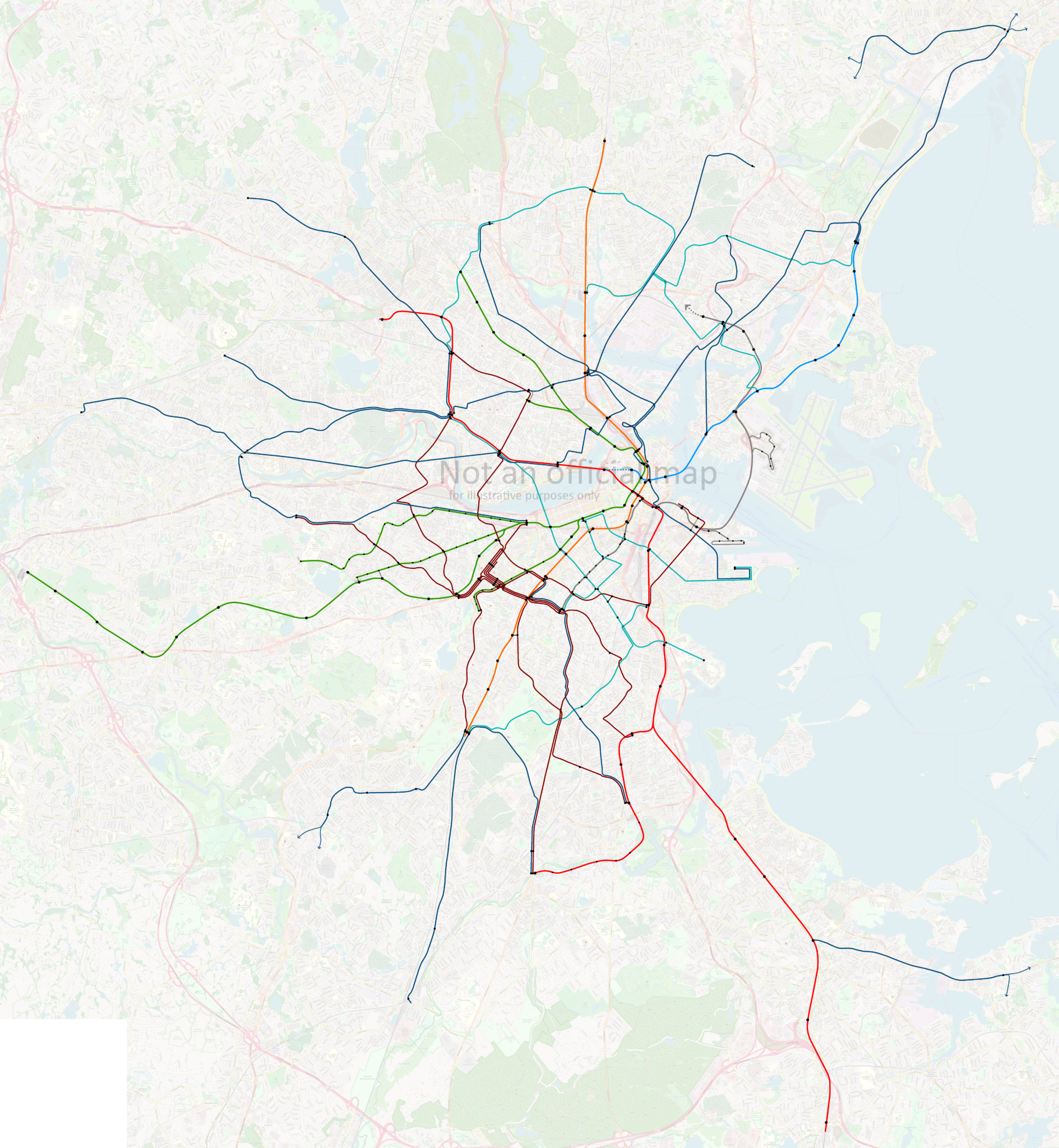
In this post, I will share a map I have created to illustrate the Redesign’s “15-minute network”: a series of bus routes that are proposed to have 15-min-or-better headways all day from 5am to 1am, seven days a week. I’ll use the map to highlight some system-level features of the Redesign, and hopefully provide a framework for deeper discussion.

The Previous 15-Minute Network

Some of you may recall that I made a similar map of then-current all-day high-frequency MBTA bus services in the past. My methodology was a little different, so it isn’t a perfect comparison, but it is a useful starting point for our discussion today.

I also wrote on ArchBoston a detailed analysis of this network and its notable features, as well as a follow-up analysis specifically on the Dorchester network. There were a few things that stood out in that analysis:

  • Very few circumferential or crosstown corridors — almost everything was radial
  • Morning peak frequencies were often higher than afternoon
  • The bus network “breathes”
    • An entire subnetwork of high frequency services turns on and off during the peak, providing much more comprehensive service during rush hour, but a signficantly sparser network during middays, evenings, and weekends
  • The entire northern quadrant of the network — everything between the Red Line and the Blue Line — was bereft of (intentional) high-frequency all-day routes, with the sole exceptions of the 111 in Chelsea and the 116/117 in Chelsea/Revere
  • Some communities, like Everett, don’t show up on the “Gold Network” (high freq all day) because they are instead served by a more diffuse number of routes spread across the city, operating at lower frequencies
  • The absence of the North Shore network — meaning the absence of consistent high frequency service — was conspicuous
  • The Dorchester network is one-of-a-kind, with features that don’t exist elsewhere
    • The network itself is actually three networks superimposed: a “10-minute all-day network”, a “15-min peak, low off-peak network”, and a “low frequency network” — most routes fall very cleanly into one of these three buckets

(Interestingly, that last point about the Dorchester network[s] seemed to be on the mind of the Redesigners as well — they’ve also adopted three primary tiers: a “≤15-minute all-day network,” a mid-frequency network that I’m guessing will be “15-min peak, 30-min off-peak”, and a low frequency network that, like Dorchester’s, would mostly see hourly services. I won’t really go into much detail here, but in my previous analysis, I did note consistent characteristics about each of the Dorchester subnetworks, and I see many of those ideas applied systemwide in the Redesign.)

I mention all of these points because I believe the Redesign recognized these features as well, and explicitly designed their proposal to address them.

The Proposed 15-Minute Network

The Redesign calls for a series of 26 high-frequency routes that would see 15-min-or-better headways all day everyday from 5am to 1am. This proposal goes much farther than the system I described above — in particular with its commitment to late night and weekend service. Vanishingly few corridors see any level of service approaching this currently. Routes on this network would be indicated by a “T” prepended to their route number: the T39, the T111, and so on.

I’ve spent a while digging through the weeds of the Redesign, and have concluded that the 15-Minute Network is composed of three kinds of routes.

Radial Routes

These are straightforward: routes that radiate out from the core, and which feed into major transfer stations such as Harvard or Forest Hills. On my map below, I have used a dark blue for these routes. Most of these routes are unsurprising, and many of them are identified on my Gold Network map above.

Circumferential Routes

These routes offer crosstown service that goes around the core rather than pointing toward it. Some of these routes behave like radial routes as they approach their terminals; for example, the southern half of the T96 essentially radiates out from Porter and Davis. So these routes still will be used by commuters going to downtown — but they also will enable journeys between multiple subway lines that can avoid going all the way to downtown. The T1 is a classic example, connecting Roxbury and Cambridge without requiring riders to change at Downtown Crossing.

Two exceptions

There are two proposed routes that do not fit cleanly into the categories above or below: the T109 and T101, both running through Sullivan. North of Sullivan, they behave clearly like radial routes, to Medford/Malden, and to Everett/Malden. South of Sullivan, they do something that bus routes historically have not done: continue on from one transfer station to another.

Traditionally, these would be considered circumferential routes. However, I have mapped them as radial routes — I believe the Redesigners are trying to reconceptualize these corridors as radiating instead from Harvard and from Kendall, passing through Sullivan somewhat incidentally. I of course have no insight into their actual thought process, but I think it reflects general trends they’ve shown in favor of longer routes that pass through multiple quadrants of the system.

Longwood Medical Area Routes

This is by far the most seismic shift in the redesigned network. For the first time, Boston is proposing a transit network that acknowledges that Longwood is a major employment center, a third “downtown” equivalent to Back Bay and the Financial District. See for yourself:

The current network requies riders to rely on employee shuttles, bus transfers at Ruggles, funneling riders on to the E Line and D Line, and lengthy walks. Despite being less than 2 miles away, commuters to LMA from Warren St currently have a single one-seat option — the 19, which only runs to Longwood during peak hours, mostly falls short of 15-minute headways during peak, stops running altogether by mid-evening, and offers no weekend service. (And it was no better pre-pandemic either.)

The Redesign proposes extending most major routes from Ruggles beyond to Longwood; it extends Cambridge crosstown service beyond Central to Inman, Union, and Porter; it adds a new crosstown route to the Seaport; and it increases frequencies on most existing routes.

When I did my analysis in 2020, the Kenmore-Longwood-Ruggles corridor saw 15 buses per hour during the morning peak, 4 per hour midday, and 6 per hour during the evening peak. The Redesign notes that exact routings through LMA are tentative pending further study, but by my count, the number of buses per hour between Longwood and Ruggles, Nubian, or Roxbury Crossing is proposed to increase to at least 20 buses per hour, all day.

I’ve colored the Longwood routes in dark red on the map. Some also act as radial routes to other hubs, and some do double duty as circumferential services in the larger network. But Longwood is undeniably the center of gravity, and makes for a distinct subnetwork, worthy of its own identification.

The Map

A few additional notes here:

  • This map is my creation, based on materials published by the MBTA; it is not an official map and any errors are mine. I recommend using my map as a jumping off point before reviewing the official materials.
  • Each route is marked separately and indicates a minimum of 15-minute headways (4 buses per hour) all day every day — I am sure that many if not most routes will see significantly higher headways during peak
  • Certain major bus stops are indicated, largely for the purpose of indicating transfer points to rapid transit; stop placement is not exact
  • Some potential “transfers” would require some walking, indicated by a dotted black line
  • The proposed Blue-Red Connector and potential Silver Line Extensions are indicated with dotted lines
  • Some corridors see high-frequency service provided by layered mid-frequency services; these are mostly indicated by the line splitting and ending with arrows
  • This map is not precise and is meant to illustrate the overall network, not detail individual routes
  • Some routes have been simplified to reduce clutter. For example, the T39, T9, T70, and most of the routes in Chelsea, all have significant stretches where the route splits on to parallel one-way streets; most of these, I have simplified by drawing the route through the block in between the streets

And voilà:

If the full-size version is killing your browser, here is a link to a slightly lower-resolution version.

Here’s a detail view on Back Bay and Longwood, probably the most visually cluttered part of the map:

Conclusion

I do want to emphasize again that I am not trying to evaluate the quality or suitability of the Better Bus Project’s Bus Network Redesign proposals. There are elements of the proposal that I believe are transformative in that they are shifting the conversation in ways that are vitally necessary: centering Longwood, insisting on consistent high frequencies all day everyday, and creating wholesale new corridors that do not descend from the old streetcar network.

But the devil is always in the details, and there are many details to sort through in this proposal. My hope is that my overview and map can make it easier for you to wrap your head around this sprawling project, and from there, dive into the details, well-armed with a larger context.

Useful Things page created

I’ve created a page called “Useful Things“. There is an incredible wealth of information available online these days, some of it produced by official agencies, and some created by devoted enthusiasts. This list is my effort to draw attention to particular resources I’ve found useful.

Some of these materials are relatively well-known — Vanshnookenraggen‘s marvelous track maps, for example. Others are, I believe, more obscure — tucked away in massive collections, or legacies of earlier days of the internet. My list is hardly exhaustive or comprehensive, nor is it a “who’s who” of our transit enthusiast community; we are very fortunate to have such an active community, and I could never hope to list everyone.

If you have suggestions of other resources similar to the ones I’ve listed here, let me know!