
In December of last year, I submitted two maps to the Boston Public Library’s Norman B. Leventhal Map & Education Center’s Transportation Dreams contest. The first is entitled “Project Electric Sheep,” and the second is “Project Gold Line.”
I’m a firm believer in dual creative processes — “campaign in poetry, govern in prose,” “write drunk, edit sober” (in the metaphorical sense), creation and refinement. These two maps present a similar duality: one is wider-ranging in its creativity; the other is a refinement into a focused proposal.
I do want to emphasize that, even on the creative map, all proposals are grounded in examinations of feasibility, cost-effectiveness, and efficiency. These are indeed “transportation dreams”, but they absolutely could be realities.
(I am told these and the other submissions will be on display at the BPL through the end of February!)
“Project Electric Sheep” — a feasible yet fun “crayon map”
This is the statement accompanying my submission:
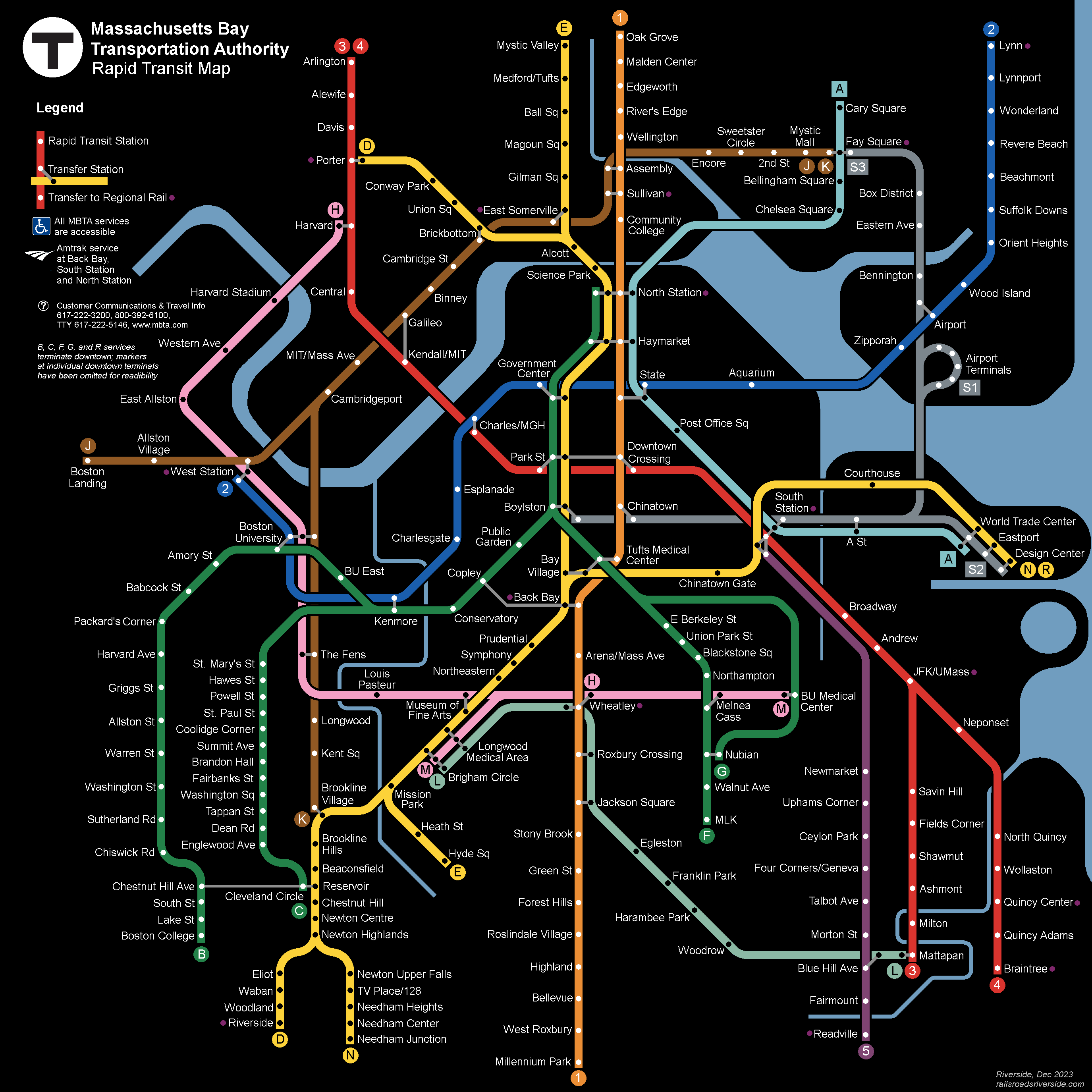
This map has been perhaps a decade or more in the making. Drawing heavily on discussions I’ve participated in on ArchBoston, I have sought to generate a vision for Boston transit that is both inspiring and feasible.
This design adds over 44 miles of rail to the T’s existing network, only about 9 miles of which would require new tunneling. By focusing on existing infrastructure, extant ROWs, and opportunities for low-cost construction (such as wide streets and areas with well-mapped geologies), we can achieve a radical increase in transit access across the region.
My proposals are built on data from a range of sources, including:
- ridership data from the Blue Book portal and Better Bus Profiles,
- employment and demographic data from the US Census (especially On The Map), Go Boston 2030, and other sources,
- a slew of project studies dating back over 100 years,
- the TCRP’s Track Design Handbook for Light Rail Transit,
- geospatial data from Google Maps, OpenStreetMap, and other sources (particularly old Bromley Atlases),
- USGS geological data,
- newspaper clippings sourced through Wikipedia (with grateful thanks to the tireless contributors there), and
- numerous historical works by Frank Cheney, Anthony Sammarco, Bradley Clarke, O.R. Cummings, George Chiasson, Jr, Jonathan Belcher, Thomas Humphrey and others
I have also drawn on the qualitative experiences of myself and other T riders.
This map would not have been possible without the years of collaborative discussion at ArchBoston. Much of my thought process in developing this map is documented there, and some proposals are also documented on my website (ever a work in progress).
A small number of stations have been renamed on this map, for ease of wayfinding and to celebrate a fuller array of figures from Boston’s rich history.
This diagram includes the “Gold Line,” an articulation of a long-discussed idea on ArchBoston, which is presented in greater detail in my second submission (below) and here on my website.
(The submitted map had the Bronze Line J service terminating at West Station rather than Boston Landing. Further details in the appendix. The submitted map also had the labels for Edgeworth, River’s Edge, and Wellington in incorrect order, which I have fixed here.)
This diagram is, in some ways, meant to be “fun” (in a way that crayon maps are supposed to be). There isn’t a specific date tied to this map, and it neither represents a “preferred build” nor a “full build” nor a “must build”. Rather, it’s a vision of one possible future.
Project Gold Line
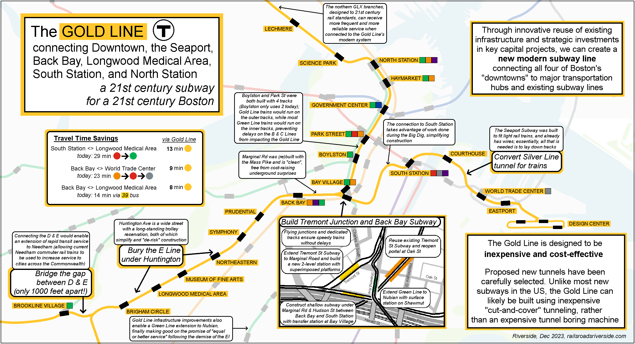
This is the statement accompanying my submission:
Like my other submission, this map has also been long in the making.
Over the last decade, an ongoing discussion on ArchBoston has examined ways to remake the Green Line into a better version of itself. These discussions have been wide-ranging, at times ruthless in pragmatism, and equally unbound in imagination.
Only in the last couple of years has a consensus emerged on certain key pieces of this “Green Line Reconfiguration”. I myself have struggled to find a way to articulate the possibilities afforded by these (relatively mundane and unflashy) key pieces.
Which brings us to: the Gold Line. The “Gold Line” concept seeks to pithily capture the key projects needed to unlock the system’s full potential:
- Reroute the E Line via Back Bay to utilize the unused Tremont St Subway
- Extend the E Line’s subway west down Huntington, at least to Brigham Circle
- Construct a short subway to South Station and run trains through the Silver Line tunnel, linking the Seaport, Downtown, Back Bay, and Longwood
There are additional components beyond these, including connecting the D and E Lines to create a full-length rapid transit line, as well as extending the Green Line to Nubian Square, but the three investments listed above would, in tandem, be transformative.
Particular data sources include:
- ridership data from the Blue Book portal and Better Bus Profiles,
- employment and demographic data from the US Census (especially On The Map), Go Boston 2030, and other sources,
- relevant project studies, particularly the never-built Silver Line Phase 3 (such as its DEIS),
- the TCRP’s Track Design Handbook for Light Rail Transit,
- geospatial data from Google Maps, OpenStreetMap, and other sources (particularly old Bromley Atlases), and
- USGS geological data
Beyond ArchBoston, some of these proposals are also documented on my website (ever a work in progress).
Additional details on the Gold Line concept are available here on my website.
~~~
Teban54Transit also submitted a map to Transportation Dreams detailing the Green Line Reconfiguration concept. He and I corresponded while creating our maps and we decided to intentionally pursue different approaches. My Gold Line map focuses on a set of core components, while Project Electric Sheep shows the Gold Line in a systemwide context with other extensions, such as a Bronze Line through Kendall; his map falls in between, showing a larger and more detailed view of the expansions to the existing Green Line that become possible through the Green Line Reconfiguration. Our maps have some differences, which intentionally demonstrates the flexibility of the improvements we propose.
This is a really cool vision for the future, where public transit in Boston is more useful and reliable. And such visions are important and valuable without being detailed roadmaps. But, I can’t help but see a lot of the specific service changes in the map to not be feasible:
BLUE LINE: A few things here. First, whether it is designed as new right-of-way or an expansion of the existing Commuter Rail line of way, our modern process of environmental review will never allow for an extension to Lynn, full stop. I also believe that the Commuter Rail line that goes through Lynn would never be approved as a new ROW today either, for the same reasons (rising sea level, running through a marsh). I understand that it’s been proposed many times, but it’s just never going to happen. Better to focus investment on transforming the current “commuter rail” service to electrified, frequent, regional rail. Second, the engineering feasibility of the Red-Blue Connector has not been verified, and there are reasons to believe it may not be possible due to the high water table. We might need to see some kind of surface-level transit improvements on Cambridge St instead. Finally, again for the same reason as #1 and #2, it’s likely that you can’t have underground blue line service along the esplanade. If there were a big re-design and road diet for Storrow Drive, that service could be on the surface but that would come at a huge cost.
BRONZE LINE: The dream of having some kind of rapid-transit train service along the Grand Junction line is another common idea that’s been discussed for a long time but it is not that likely. The MBTA uses this line to move Commuter Rail trains between the northern and southern parts of the system. So, unless an alternative or a direct North-South Station link is added to the vision, this is not possible. There is also the question of where Bronze Line service through Cambridge would be underground, or at surface-level. Surface level is likely not possible, since there are 4 major street crossings with heavy urban development that would preclude adding grade-separation (Mass Ave, Main St, Broadway, and Cambridge St). I would love to see a new tunnel in this area, which would perhaps run the more-frequent rapid-transit trains underground, and a re-built surface line used to move the Commuter Rail trains (is mostly done at night when traffic level is low). Such a newly-built Grand Junction corridor would likely need to accommodate the planned bike path on the surface too.
TRAIN SERVICE TO THE SEAPORT: This is long overdue, as the population growth in that area has exceeded expectations. It makes perfect sense to run light rail in the Seaport Tunnel, and to build a new tunnel on the other side of South Station to take pressure off DTX/Park/State stations. But do you have thoughts about how we could find space for this train east of Silver Line Way?
If the new lines are all subways, do they run beneath existing wide roads? Boston does need more tunnels but it’s difficult to add new ones in the urban core because this is an old and dense city and big buildings have basements that box in roads on either side underground.
Overall, I think a vision for Boston transit needs to accommodate for a greater variety of service modes. In some places, new subways may be possible. In others, we can add rapid-transit lines within existing Commuter Rail ROWs like we did with the GLX. But there are other options people don’t seem to talk about:
ELEVATED RAIL: Older Bostonians seem to have some trauma from the noise of the old elevated trains, like when the Orange Line line went to Nubian Square. But the truth is, Boston is crowded and there is only so much space on and under the ground remaining. The Rose Kennedy Greenway, for example, could play host to a new elevated train, that could be driverless and run back and forth every few minutes between North and South Station. And there may be other wide roads that could support this model.
TRAMS and TRANSITWAYS: Transitways, which re-purpose existing streets to exclude all car traffic other than emergency vehicles, delivery vehicles at certain hours of the night, and public transit vehicles, could really help provide the kind of direct service we need to get people out of private cars. These transitways could run buses or trams. If we had one of these on Mass Ave, for example, it could connect the Red Line at Central to the Green and Orange Lines in Boston.
I also think that direct service to Logan is essential. Perhaps a people mover that connects directly to the Blue Line.
Overall, an exciting vision for the future!!
Thanks for the detailed comments!
BLX TO LYNN: it may well be that it would fail environmental review, but I’m gonna keep putting it on my maps until and unless it does 🙂 Electrified Regional Rail is a good start, but ultimately will not provide frequencies as high as the Blue Line, and North Shore buses likely will continue to need to run all the way to Wonderland, which hobbles their ability to provide robust service in Lynn and surrounding communities. And if you look at Census data, there is a noticeable orientation of North Shore commuters to East Boston + Revere (doubtless due to the generations of access via Blue Line, and before that BRB&L), rather than downtown, and Regional Rail would be weaker for that.
In general, if something like BLX to Lynn fails environmental review, then there’s a larger problem with environmental reviews. The wetlands in question already have a railroad trestle and a highway running through it. The Blue Line would *reduce* traffic and emissions from both, to say nothing about the broader environmental benefits across the region. The solution is to fix the environmental review process, not decline to build transit.
BLUE-RED: similar story — if the feasibility review actually fails, then we can modify proposals as needed, but for now it’s such a vital potential enhancement that I’ll keep it on my maps until and unless a review pans it. (If memory serves, the T did a preliminary analysis last year, and I think there was a favorable outlook there?) I agree that potentially an elevated connection could need to be considered instead of a subway, and I agree that a modern elevated could be much more reasonable
BLX TO KENMORE: this would be a “capped cover”, so actually even shallower than a cut-and-cover, and would potentially get a linear park on top of it. But yes, this would entail a significant road diet for Storrow (which should be done anyway — that is a beautiful park along the water, and it shouldn’t have a highway running next to it), where the Blue Line takes over the eastbound road (the three lanes furthest from the water). The hop-skip-and-a-jump through Charlesgate would be a bit more difficult, but that’s a much shorter segment
BRONZE LINE — COMMUTER RAIL MOVEMENTS: as I understand it, these moves will become less frequent as the T expands maintenance facilities and is able to keep the southside and northside fleets more self-sufficient. The less-frequent moves can be accomplished via the track between Worcester and Ayer — it’s obviously further out, but those moves would be planned in advance and would not need to be done “on the fly” the way the Grand Junction currently is used for. It’s also worth pointing out: the last time I checked, the B Line *alone* (between Boston College & Blandford St) has about as much ridership as the entire northside commuter rail. Obviously I’m not saying that the commuter rail should be sacrificed for the Urban Ring, but I think it’s important to keep the relative benefits in mind
BRONZE LINE — GRADE SEPARATION: this is something I intend to do a more detailed write-up on, but it would be largely surface, with grade separated crossings at everything except Main St (which should be feasible, based on analysis by me and others). But even without grade separation, the advantage of light rail is that it can be integrated into the normal traffic light cycles, which makes grade separation useful but not critical. Grade separation would improve reliability, speed, and likely frequencies, but it should not be mandatory on Day 1
SEAPORT: glad you like the idea! Past Silver Line Way (called “Eastport” on my map), I think there are a number of options, and I’ve intentionally left it vague. One option would be simply to terminate trains at Eastport. Another option would be to send a subset of trains running at street level (hopefully in transit lanes) along the route of today’s SL2. Another option would be to use my proposed reconfiguration of the Silver Line to maintain service to the eastern part of the Seaport. Demand is definitely lower there than in the western and central parts, so I think a subway is unnecessary
ARE NEW LINES SUBWAYS?: for the most part, no. Most of the extensions on the map are at surface level. Subways include a longer subway under Huntington, a subway under Comm Ave to around Amory St, the subway along the Mass Pike connecting the Huntington Subway to the Seaport Subway, the Blue Line extension to Kenmore and possibly West Station, and possibly the Green Line branch to Nubian via BU Med Ctr (at least partially — this one might be an el alongside I-93). As I mentioned, the map shows 44 miles of new lines, only 9 miles of which require new tunneling.
ELEVATEDS: While most of my proposals here do not rely on elevateds, I absolutely agree that modern elevateds could be very different from what Bostonians remember and could be extremely valuable. One place my map does assume an elevated is the connection between Sullivan and East Somerville, though that section is further away from residential buildings
TRAMS & TRANSITWAYS: Fully agree here. An entire layer is absent (but hopefully implied) from this map — a robust network of BRT infrastructure, designed to provide speedy frequent service at surface level. For the most part, that BRT network reflects the one proposed in the latest Bus Network Redesign. These would include busways (like on Columbus Ave today) and transitways. (The Pink Line on my map actually runs in a transitway from The Fens to BU Med Ctr.) I also didn’t highlight frequent Regional Rail service (though transfers are indicated with a purple dot at stations), but it is also very much part of this vision
DIRECT SERVICE TO LOGAN: in an ideal future, the Gold Line would (eventually) be extended across the harbor to connect directly to Logan — a one-seat ride between Logan, the Seaport, Downtown, South Station, Back Bay, and Longwood. But that would be a massive project, and beyond the scope of this map. For now, improved Silver Line and Massport shuttle service is my recommendation, and I agree that an APM could be an appropriate solution here as well
Thanks for the kind words! I’m glad you liked it!