RIPTA is in dire straits, the victim of ill-advised “right-sizing”. Providence is in an acute housing crisis — in fact, across the entire state of Rhode Island there is not a single municipality where the typical renter can afford a place to live.
Here, I present the Providence SkyLine: a concept for reimagining Rhode Island’s transportation system by linking together existing infrastructure with targeted investments, paired with ambitious transit-oriented development that would both alleviate the housing crisis and provide Rhode Islanders a viable path to car-free living.
The SkyLine is designed to take the urban scar tissue created by 20th century highways and other car-centric development, and repurpose those spaces to stitch Greater Providence back together again.
This is not a new idea: in the 1980s we created beautiful space on the Woonasquatucket River by relocating the train station; in the early years of the 21st century, we did the same on a grander scale by relocating Interstate 195 to create a whole new neighborhood in downtown Providence. We can do it again, and transform our entire region.
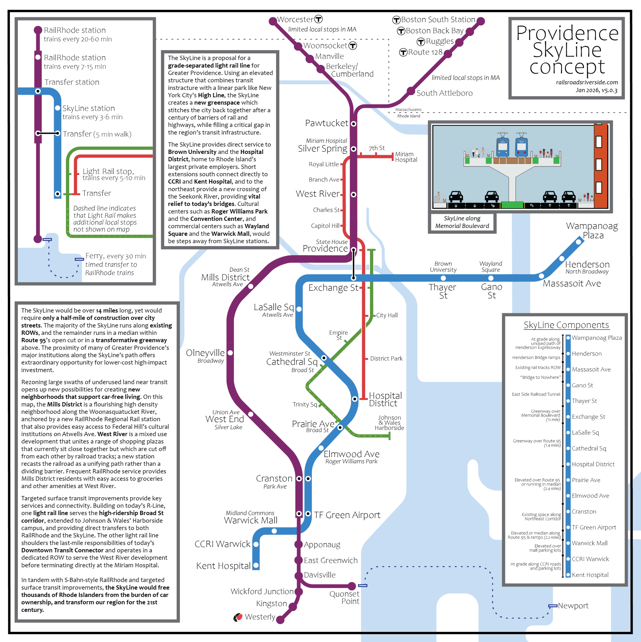
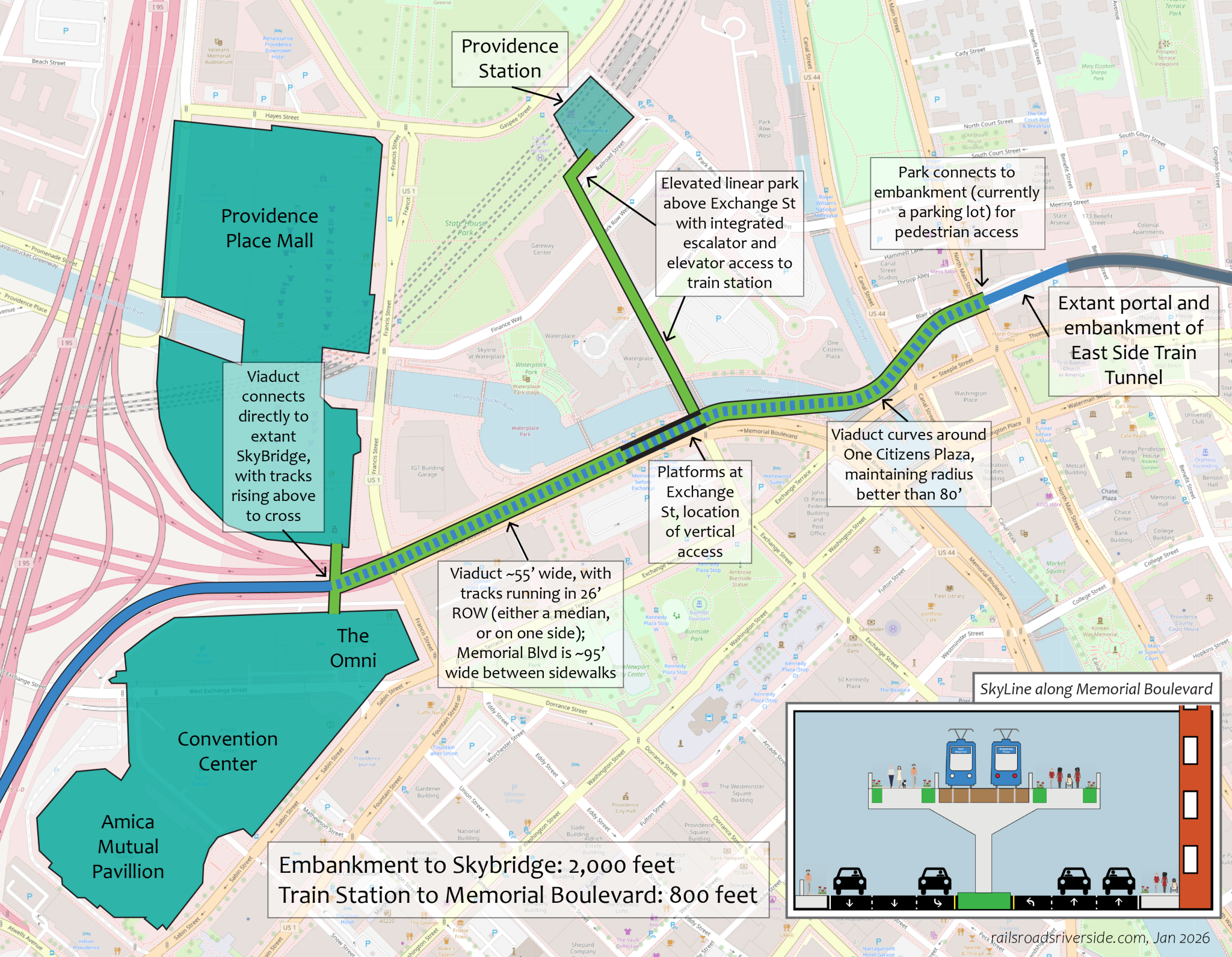
The SkyLine is a proposal for a grade-separated light rail line for Greater Providence. Using an elevated structure that combines transit instracture with a linear park like New York City’s High Line, the SkyLine creates a new greenspace which stitches the city back together after a century of barriers of rail and highways, while filling a critical gap in the region’s transit infrastructure.
The SkyLine provides direct service to Brown University and the Hospital District, home to Rhode Island’s largest private employers. Short extensions south connect directly to CCRI’s Warwick Campus and Kent Hospital, and to the northeast provide a new crossing of the Seekonk River, providing vital relief to today’s bridges. Cultural centers such as Roger Williams Park and the Convention Center, and commercial centers such as Wayland Square and the Warwick Mall, would be steps away from SkyLine stations.
The SkyLine would be over 14 miles long, yet would require only a half-mile of construction over city streets. The majority of the SkyLine runs along existing ROWs, and the remainder runs in a median within Route 95’s open cut or in a transformative greenway above. The proximity of many of Greater Providence’s major institutions along the SkyLine’s path offers extraordinary opportunity for lower-cost high-impact investment.
Rezoning large swaths of underused land near transit opens up new possibilities for creating new neighborhoods that support car-free living. On this map, the Mills District is a flourishing high density neighborhood along the Woonasquatucket River, anchored by a new RailRhode Regional Rail station that also provides easy access to Federal Hill’s cultural institutions on Atwells Ave. West River is a mixed use development that unites a range of shopping plazas that currently sit close together but which are cut off from each other by railroad tracks; a new station recasts the railroad as a unifying path rather than a dividing barrier. Frequent RailRhode service provides Mills District residents with easy access to groceries and other amenities at West River.
Targeted surface transit improvements provide key services and connectivity. Building on today’s R-Line, one light rail line serves the high-ridership Broad St corridor, extended to Johnson & Wales’ Harborside campus, and providing direct transfers to both RailRhode and the SkyLine. The other light rail line shoulders the last-mile responsibilities of today’s Downtown Transit Connector and operates in a dedicated ROW to serve the West River development before terminating directly at the Miriam Hospital.
In tandem with S-Bahn-style RailRhode and targeted surface transit improvements, the SkyLine would free thousands of Rhode Islanders from the burden of car ownership, and transform our region for the 21st century.