
Some of the earliest public feedback on the MBTA’s Bus Network Redesign (mapped in a previous post) came from residents of Somerville (and, to a lesser extent, Cambridge) who were – almost unanimously – unhappy with the proposals.
City Councilor Judy Pineda Neufeld gave lengthy feedback, praising the increases in frequency, and raising serious concerns for riders from West Somerville (in particular Clarendon Hill), and those trying to reach Union Square and the nearby Market Basket. Others seconded the concern about lack of access to Market Basket, as well as poor connectivity to GLX, some suggested that GLX was mistakenly being viewed as a substitute for current bus service, and numerous people noted that a lot of ideas in the Redesign were pretty good, but that Somerville appeared to draw the proverbial short straw.
Based on my anecdotal observation on social media platforms, it appears that initial reaction from other communities has been more muted; this may change in the coming weeks with the further feedback sessions the T has planned. But still, I thought it was interesting that there was such an immediate and resounding response by comparison from Somerville.
I don’t envy the Redesigners their task with the Northwest Quadrant um, Sextant (?). Uniquely, they had to design for a system that doesn’t exist yet: GLX will be a seismic shift in transit access for Somerville, and while some of its effects are predictable, some are not. That’s a pretty big wildcard to toss into the mix.
The early signs suggest the Redesigners missed the mark, at least from the perspective of the community. I wanted to dig in to this and – of course – wanted to make a map to add to the conversation. I believe that I have been able to piece together a visualization that offers context and some explanation for this initial pushback; based on these, I have also generated some modest suggestions for revisions to the Redesign.
Further details are below, but the core of my suggestion is “swapping” the proposed T39 and proposed 90; this provides an increase in service to most riders, but is a more conservative change that does not disrupt existing travel patterns. This extension can be “paid for” by a dramatic shortening of the proposed 87 to its core service area, a reroute of the 90 to a shorter well-established corridor, and the use of a lower-freq crosstown route and a shuttle service to address connectivity gaps to Sullivan and Assembly.
Contents
The Map
I had two goals with this map: visualize frequency, and visualize potential destinations. I chose these goals because they reflected themes I saw in the initial feedback: frustration at multiple transfers (meaning, need for direct access to a larger number of destinations), and loss of service, particularly for lower-income residents (which I believe in some cases was a result of the Redesign’s shift away from “mid-low frequency” routes – think 45-min peak headways, that kind of thing).
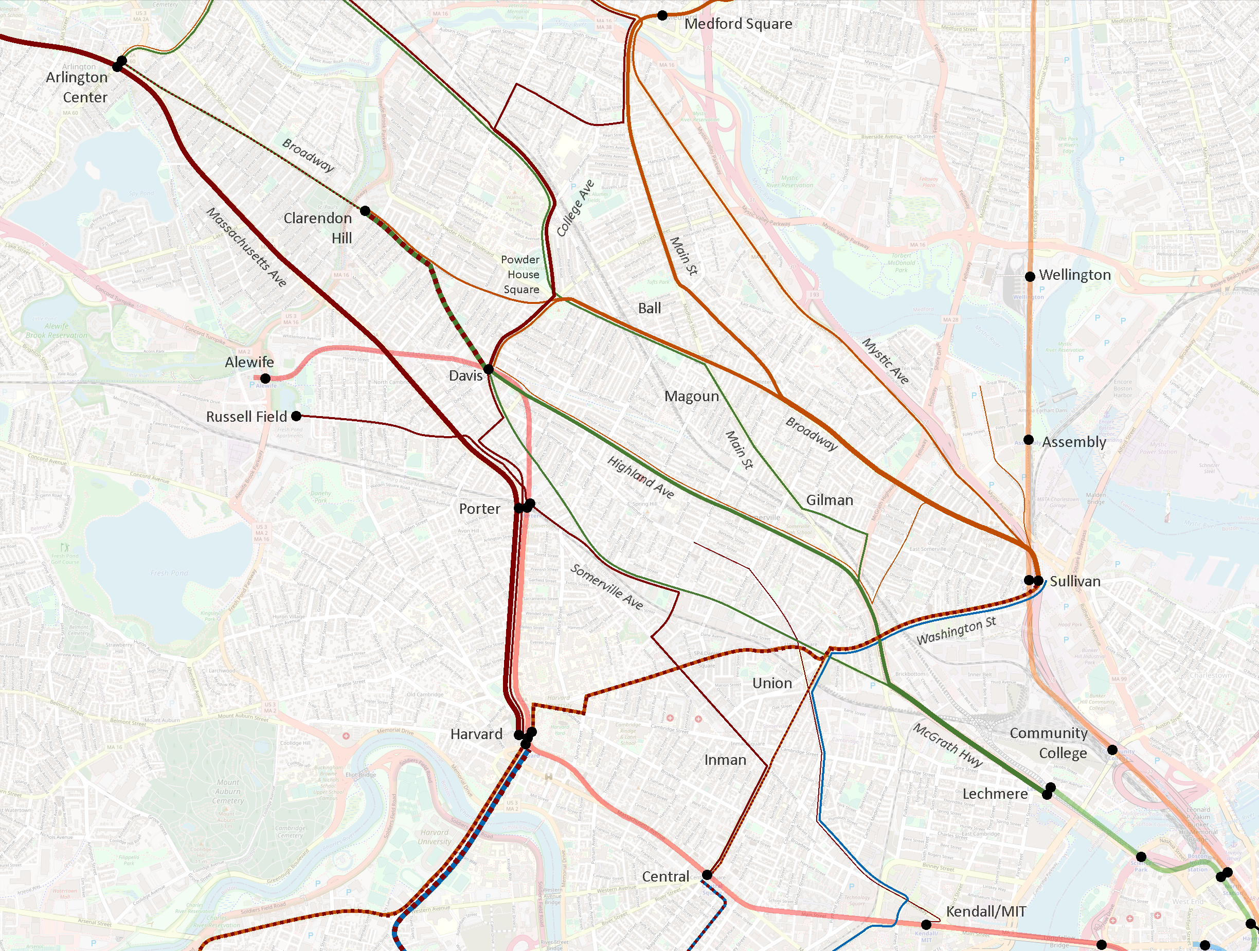
Line color denotes reachable destinations. This system isn’t perfect, but I think captured some key dynamics.
- Dark red lines reach Red Line stations
- Dark orange lines reach Sullivan Square specifically, and light orange lines serve other Orange Line stations
- Dark green lines reach Lechmere
- Dark blue lines serve Longwood Medical Area
Some lines see multiple colors, meaning a rider might board a bus for multiple destinations; a good example of this is the 87 & 88 north of Davis, where a rider might board destined for Davis or for Lechmere.
Line width indicates frequency.
- The thinnest lines have peak headways more than 30 minutes
- such as the 85 or 90
- The next size up, forming a large swath of the network, denotes headways between 15 and 30 minutes at peak, including
- the 95 along Mystic Ave,
- the 87 along Somerville Ave,
- the 83 along Somerville Ave and Beacon St
- Thick lines indicate peak headways of 15 minutes or better – matching the target for the Redesign’s frequent network, and including major corridors along
- Broadway
- Highland Ave,
- College Ave,
- Washington St
- The thickest lines – matching the width of the rapid transit lines – see peak headways of less than 10 minutes, including
- the 77,
- the cumulative 87 & 88 between Davis and Clarendon Hill,
- the 101 & 89 on Broadway running into Sullivan
Here’s a version of the current system only showing routes that see 15-min peak headways or better.
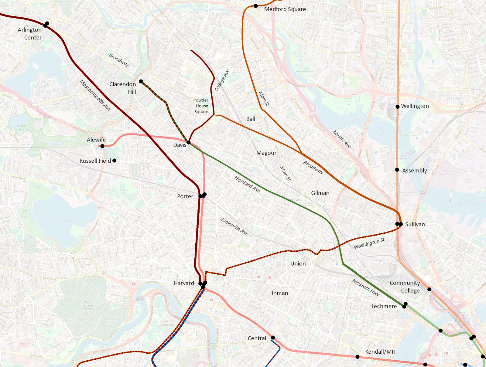
Here we see six distinct corridors emerge:
- Medford Square (and Malden) – Main St – Broadway – Sullivan
- Powder House Square – Broadway – Sullivan
- College Ave – Powder House Square – Davis
- Clarendon Hill – Davis – Highland Ave – Lechmere
- Arlington Center – Porter – Harvard
- Sullivan – Union – Harvard – Allston/Brighton and Reservoir
I then created a map using the same design language to visualize the Redesign proposal.
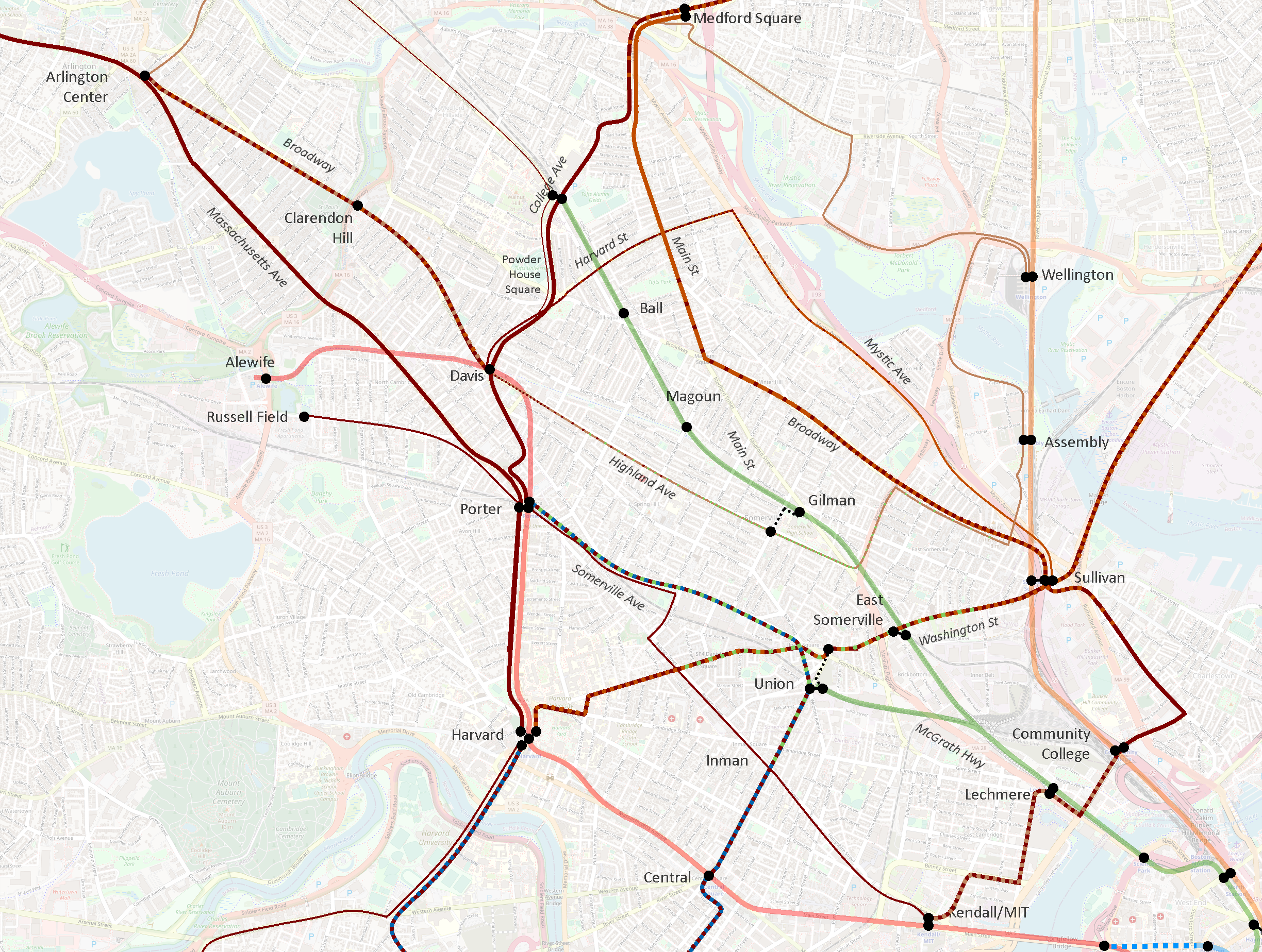
(I recommend opening the “before” and “after” images in separate tabs, and then switching between them to hone in on the differences. I tried creating a GIF, but was unsatisfied with the results.)
Impact to current high-freq corridors
Let’s first review the impact to the current high-freq corridors:
- Medford Square (and Malden) – Main St – Broadway – Sullivan
- Largely intact
- Goes near but does not provide transfer to GLX at Ball Sq
- Extended beyond Sullivan to provide a (long) one-seat ride to Lechmere and Kendall
- Powder House Square – Broadway – Sullivan
- Eliminated
- Moreover, this route is actually composed of a pair of branching routes:
- a mid-freq route to Davis
- a low-freq route direct to Clarendon Hill
- Davis and Clarendon Hill lose direct service to Ball Sq GLX and Broadway
- Davis and Clarendon Hill maintain roundabout access to Sullivan via Mystic Ave, an increase of 0.5 miles
- College Ave – Powder House Square – Davis
- Intact and strengthened
- Newly anchored at north by Medford/Tufts GLX and extension to Medford Sq
- Worth noting that the twice-hourly one-seat ride beyond Davis to Porter and Harvard is eliminated
- Clarendon Hill – Davis – Highland Ave – Lechmere
- Significantly reduced, and partially eliminated
- Clarendon Hill – Davis gets a pair of the Redesign’s “30-min-or-better” routes, which could approximate 15-min headways, but still does not meet the current service’s average sub-10-min frequencies
- Highland Ave drops into the Redesign’s “30-min-or-better” routes, but does not connect to Lechmere, or to Union GLX, or even to Gilman GLX (though it comes close), but instead is rerouted over toward Sullivan… which it doesn’t actually reach, instead ultimately diverting to Assembly
- Arlington Center – Porter – Harvard
- Intact
- Sullivan – Union – Harvard – Allston/Brighton and Reservoir
- Partially eliminated
- Sullivan – Harvard is maintained, and combined with through-service to Everett
- However, ridership from one side of Harvard to the other is actually surprisingly high, so this elimination is not trivial
Of the six current high-frequency corridors, three are maintained and three are significantly impacted. This does seem counterintuitive – as far as I can tell, all other existing high-freq corridors across the system were maintained in the Redesign, and most were significantly strengthened. I suspect the difference in Somerville was the future presence of the Green Line Extension.
Green Line integration (or lack thereof)
One of my biggest surprises on seeing the Redesign was how little integration there was to the GLX stations. Ball Sq and Gilman Sq will both see bus routes pass less than a quarter mile from the station without offering door-to-door service.
In addition, despite the arrival of the Green Line, Union Square now sees less connectivity than it did before, including the loss of one-seat rides from Clarendon Hill, Davis, and Kendall. As Councilor Pineda Neufeld pointed out, this also reduces access to the Market Basket in Union Square, as well as the Star Markets on Beacon St and Elm St.
I would argue that the Redesign treats the Green Line Extension more like one of its high-freq bus routes than like a rapid transit line – as if the GLX has said, “Don’t worry buses, I’ve got this stretch”, and thus bus routes are routed away from it. That is not done with any other rapid transit lines, and with good reason: rapid transit access is concentrated in discrete areas around stations; a key role of surface transit is to provide access to a station from beyond its walkshed. Unlike rapid transit, the close stop spacing of bus routes provides continuous access along the entire route, which GLX lacks.
To be clear, for over a century now, Somerville’s surface transit routes have had to play double-duty, providing both feeder service into rapid transit stations, as well as longer-distance service to support journeys that would in other areas be covered by rapid transit. GLX relieves them of the second burden, but not the first.
To wit: the entire Red Line from Davis to Kendall is doubled by surface transit routes in the Redesign. It is true that GLX’s stop spacing is closer than the Red Line’s, but it’s still well-above typical surface transit stop spacing. The Green Line is not a wholesale replacement of local buses.
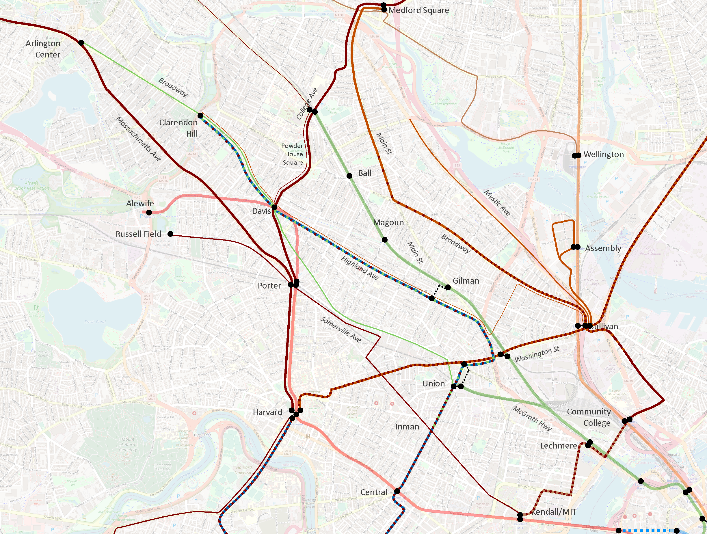
Highland Ave vs Elm St & Somerville Ave
In the current system, Highland Ave sees mostly 15-min-or-better service at peak on the 88, from Davis to Lechmere. Pre-pandemic, the average AM Peak frequency was 10 minutes. (The 90 layers on about one trip per hour to Sullivan.)
By contrast, in the current system, Elm St & Somerville Ave sees lower frequencies on the 87, wobbling between 15 and 20 minute headways. Pre-pandemic, the average AM Peak frequency was 22 minutes.
(A short stretch of half-a-mile between Elm and Park Sts on the northern half of Somerville Ave sees additional 20 minute headways on the 83, running to Central Square via Inman. North of Elm, the 87 and 83 split, though remain only a couple of blocks apart for some distance. Pre-pandemic, the 83’s average AM Peak frequency was also 22 minutes.)
In the Redesign, Highland Ave drops into the 30-min-or-better category, and loses direct connections both to the Green Line and to Sullivan. (I should again note that 30-min-or-better routes still may see high-frequency peak service, which perhaps is the vision in this case.)
By contrast, Somerville Ave sees a significant increase: the 83 holds its place, while the 87 between Union and Porter is supercharged as the T39, receiving 15-min-or-better service. Somerville Ave also maintains a direct connection to the Green Line – only one of two radial routes in Somerville that do so, the other being the T96.
In essence, the Redesign swaps the frequency tiers of Highland Ave and Elm St & Somerville Ave. As mentioned above, Highland Ave is one of the current high-freq corridors, so its exclusion is puzzling.
I am guessing that the Redesigners saw the extent to which the 88 parallels GLX, and believed the Green Line would be an adequate replacement. As discussed above, however, surface transit and rapid transit are different beasts; the 88 is being relieved of its rapid transit duties by GLX, but not its surface transit duties.
Moreover, while it’s true that the 88 parallels GLX for a lengthy distance, they diverge significantly after Magoun Sq GLX – GLX aims for Tufts and beyond, while the 88 aims for Davis and beyond. And as numerous people noted in the reactions I linked earlier, the 88’s corridor north of Davis is not meaningfully accessible from GLX.
Increasing frequency on Somerville Ave is not necessarily a bad thing – the problem is how the increase is achieved. The current Somerville Ave corridor runs uninterrupted from Clarendon Hill to Davis to Porter to Union to Lechmere. The Redesign shears off the southern half of this corridor, and joins it to an extended T39, running Porter to Union to Central and beyond to Longwood. That is a bold proposal, but it also dismantles a one-seat ride that has been in place for over a century.
This reflects a larger challenge introduced by treating the Clarendon Hill buses as feeders to Davis Sq, rather than acknowledging their actual roles as parallel spines threading the city together, radiating not from the Red Line at Davis, but from the Green Line at Lechmere.
Lack of through-running from Clarendon Hill
It is worth highlighting that the current system offers one-seat rides at least half-hourly from Clarendon Hill to:
- Davis station
- Porter station
- Harvard station
- Powder House Square
- Ball Square
- Magoun Square
- Broadway
- Sullivan station
- Highland Ave
- Somerville Ave
- Union Square
- Lechmere station
The Redesign reduces that list significantly:
- Davis station
- Powder House Square
- Highland Ave
- Sullivan station (bus journey lengthened by half mile)
- Southernmost Broadway, near Sullivan
- Ball Square (via a 6 minute walk)
Porter stationHarvard stationMagoun SquareMost of BroadwaySomerville AveUnion SquareLechmere station
For over 100 years, Somerville has been tied together by crosstown routes on Highland and Somerville. The Redesign makes the unfortunate decision to reduce the Highland corridor, and breaks what is currently a single seat journey across the city from Clarendon Hill to Union Square via Somerville Ave into an almost-certainly three-seat journey.
On paper, it may look like Clarendon Hill is all set with feeding into a hub at Davis; in reality, the Redesign takes numerous journeys that have been single-seat rides for – again I emphasize – over 100 years and makes them essentially impossible.
Suggested revisions
I want to emphasize that I don’t mean to besmirch the Redesigners or their efforts: this was a herculean task that is impossible to get perfect. Tradeoffs had to be made, and balances struck. I can understand how they arrived at their current proposal, and I also can understand why community members are deeply unhappy.
In this post, I have attempted to detail the nuances of the current system, to illustrate some of the features that I believe underlie many of the criticisms that have been levied against the Redesign. I want to conclude by offering some modest suggestions for revising the Redesign to address the concerns that have been raised.
The Map
Methodology and fudge functors
While I am not sure that it has been stated explicitly, I believe the Redesign was undertaken with a “net zero” assumption – meaning the Redesigners assumed they could only work with the existing buses the system has today, and not increase the number of buses overall. As such, I am going to frame my suggested modifications through a reallocation lens: if I propose lengthening one route, I will attempt to balance it out by shortening another.
There are also fudge factors at play here that may provide some wiggle room on these proposals. First, infrastructure upgrades such as bus lanes and transit priority signaling may enable faster service and thereby reduce the number of buses needed to maintain frequencies. Second, it may be possible to spread minor frequency decreases across multiple routes to free up enough buses to add a new route – enabling the creation of a new high-freq route without eliminating routes elsewhere.
These fudge factors cut both ways, of course – in some cases, they may make things harder, not easier. So while I’ve done my best to consider these suggestions as carefully as I can, I am of course limited to the data available to me; these suggestions should thus be considered preliminary.
Generating a surplus
I suggest the following revisions to free up buses to accommodate additional changes below. For those interested, I’ve laid out the justifications for these changes in much greater detail in the appendix to this post.
- Shorten the proposed 87 along Mystic Ave to terminate at Harvard St
- Shorten and reroute the proposed 90 to Union Sq GLX via Somerville Ave (essentially recreating the current 87’s route)
- Institute an MBTA-run frequent shuttle service between Sullivan and the Assembly Row development, potentially leveraging public-private partnerships
Cumulatively, these modifications generate a surplus of 6.18 “route-miles” at 30-min-or-better frequencies.
Utilizing the surplus
- Reroute and extend the proposed T39, running Union Sq – Highland Ave – Davis – Clarendon Hill
- Revise the proposed network to include a 60-min-or-better route running Davis – Highland Ave – Sullivan, along the corridor of the current 90 (it may be possible to run this service at 30-min-or-better)
Suggested revisions in review
The core of my suggestion is “swapping” the proposed T39 and proposed 90; this provides an increase in service to most riders, but is a more conservative change that does not disrupt existing travel patterns. This extension can be “paid for” by a dramatic shortening of the proposed 87 to its core service area, a reroute of the 90 to a shorter well-established corridor, and the use of a lower-freq crosstown route and a shuttle service to address connectivity gaps to Sullivan and Assembly.
As detailed in my appendix, I believe these changes
- are achievable with a net-zero impact on the overall Redesign
- maintain better continuity with established travel patterns and community corridors
- still provide specific and general enhancements of service to most riders, per the Redesign’s objectives and philosophy
I commend the Redesign team on their thorough and innovative work. I hope they will carefully review these suggestions and the further feedback provided by the community, and consider adopting these changes into a revised version of the Bus Network Redesign.
Thank you, as always, for taking the time to read!
I really like this proposal. Highland ave is a much better route for High Feq. service than Somerville Ave. This much better preserves existing travel patterns and preserves connectivity within the town limits. Porter is an interesting connection, but Davis feels better suited to handle bus turnarounds/volume.
Topography also plays a major factor in Somerville corridor access on foot. Highland Ave essentially follows a ‘spine’ of higher topography through the city and affords pedestrians shorter hill-climbs to transit. The Next Gen. proposal’s rerouting of high freq. service to Somerville Ave. places transit access at the base of the ‘spine’ and would likely impede and discourage ridership from riders living uphill.
I do think a strong connection along Somverville Ave. from Union to Porter will become increasingly important over time, but perhaps this will be better served ‘down the road’ with an extension of the Union Sq branch of the Green Line to Porter Sq.
I still would like to see better GLX/bus integration. Gilman Sq (Pearl@Medford) and Ball Sq (Broadway) feel like missed opportunities to ‘feed’ the GLX. I also think the omission of an Arlington link to the GLX is a significant missed opportunity.
I also have a hard time understanding why the McGrath (Somerville Ave. > Mystic River (+N?)) isn’t utilized as a cross-Somerville path (now and in the redesign). Is this due to the current road configuration/engineering? Perhaps it becomes a viable route post grounding/redesign (soonish)?
Thanks for the feedback! I’m glad you like the proposal.
To your point about the other GLX stations, I discuss this topic a bit in the appendix to this post (https://railsroadsriverside.com/library/appendix-mapping-the-bus-network-redesign-somervilles-buses-present-and-proposed/#Additional_levers_for_adjusting_the_system) where I suggest potential reroutes of the T101 and the proposed 87 to better feed Ball Sq GLX and other GLX stations.
There is a still a pretty big chasm between East Somerville/Winter Hill and the western parts of the city. I would love to see you take a crack at closing that gap as well.
Yeah, this is a genuine problem. There are a few pieces here:
1) The most straightforward way I see to close that gap is along Broadway. To my eye, there is a natural corridor that runs along Broadway from Sullivan to Powder House Square to Davis. However, I’m guessing the Redesign team saw data that suggested that corridor is not as robust. Looking again at the map, I wonder if something could be achieved by swapping the T101 and T96 a bit — have the T96 run from Medford Sq down Main St and to Sullivan, and let the T101 continue on toward Davis, possibly with a diversion up to Ball Sq GLX before hitting Powder House Sq. Unfortunately, this swap would not be net-neutral: while the T101 reroute to Davis provides a small savings, the extension of the T96 to Sullivan adds an extra 1.2 miles of double-freq service. So this would require a larger rework.
2) A more modest change would be to take my suggested Davis – Highland Ave – Sullivan route and adjust it slightly by having it “cross over” to Broadway a bit further to the north, such as at Lowell St or School St (with transfer to a GLX station on the way). The problem is that, while this looks good on paper, it may be that Somerville’s infamous hills make a crossover unfeasible at those blocks. Alternatively, the Davis – Highland Ave – Sullivan 60-min-or-better route could be simply rerouted to run via Broadway instead of Highland Ave altogether — but I think that trades one problem (no Winter Hill-Davis connection) for another (no Highland Ave-Sullivan connection).
3) It may be possible to “cheat” and pull 1 bus-per-hour off of the T101 and T96 and maybe T39 to cobble together a 60-min-or-better Sullivan – Broadway – Davis route, while keeping the T routes within the high frequency threshold. I discuss this strategy a bit in my appendix: https://railsroadsriverside.com/library/appendix-mapping-the-bus-network-redesign-somervilles-buses-present-and-proposed/#Frequency_adjustment_and_infrastructure_as_fudge_factors
I live in Winter Hill and most of my rides go south on Cedar St to Harvard or down on School towards Market Basket -> Union Sq -> Inman -> Central Square and then back up on Central St. It’s too bad almost everything has to flow east/west in Somerville.
Very impressive research and thought here. A far less researched and thought out proposal would be a unidirectional loop that ran Union – Sullivan – Assembly – Magoun – Ball – Powderhouse – Davis – Union. Or a variant of it without Assembly, and maybe not Sullivan, with the downside that it wouldn’t touch the OL then.
The idea is that all of the major residential and retail areas of Somerville would then be interconnected, and also interface with OL, GL and RL. It seems plausible to complete that loop in an hour, so allocating 4 vehicles would give 15 minute headways. Potentially a good public/private project. Employers & retailers should love the version with Assembly in it.
I’m not sure a unidirectional loop would be effective here — for example, a journey from Union to Assembly might take 15 minutes, but then the journey back from Assembly to Union for take 45. But a bidirectional loop could be interesting. I know the City of Somerville has also mentioned potentially providing local transit using smaller vehicles that can handle the hills and enable north-south service — I think that could dovetail well with a public-private partnership, particularly if access to Assembly were increased, and could be amenable to (smaller) circulator routes.
I was cheating a little here: let’s look at that 45 minute return from Assembly to Union:
Assembly -> Sullivan on OL, bus return to Union.
Assembly -> Ball; GL to Gilman; walk difficulty depends on where on the hill you are.
The particular unidirectional I proposed works, but pretty much only in the direction I noted. I wouldn’t expect anyone to take the 45 minute return from any point to any other; most rides would be in the 15 – 30 minute range.
The key idea of a public/private partnership is really important; whether it is more efficient to implement that via the MBTA or another approach is yet to be seen.
While I’d love to see north-south service over the hills, all of those routes are extremely narrow single lane single direction streets, so it might be difficult to implement. A couple of tunnels through those hills would be great.
Please keep up the great thought!