
A subsequent revision of this concept is described here.
What if the Green Line radiated out — not from Kenmore — but from Longwood Medical Area?
It’s a fair question, I’d argue: Longwood, not Kenmore, is the employment center of gravity at that end of the Green Line. Why shouldn’t it be the western anchor?
The perennial “D-to-E” idea (connecting the D at Brookline Village to the E at Riverway) offers a version of this idea, where the Highland Branch would now radiate out from Longwood instead of Kenmore. The E/39 likewise is still anchored at Longwood, so no change needed. What about the other branches?
Well, the C’s role is to serve Beacon St, Coolidge Corner, and Cleveland Circle. The most direct route would radiate out along Longwood Avenue (which today is pretty narrow). But! The Beacon St Portal is less than a skant third of a mile to the northernmost corner of the LMA (at Fenway & Brookline Ave). That’s actually quite close. Longwood Ave is the most direct route, yes, but “diverting” via the whole of Beacon St costs you less than half a mile — and provides the benefit of significantly increased access to a major employment center.
Radiating from Longwood rather than Kenmore has the largest impact on the B. The neighborhoods that are strung in sequence from Kenmore really break down into at least 2 if not 3 segments that each would warrant a radial branch (e.g. each along Washington St, Harvard St, and toward BU).
***
We’ve long despaired of how to provide good transit service to Longwood. Sitting between Kenmore and Huntington, it has long seemed like the purview of circumferential service, despite the neighborhood’s major importance as an employment center. But going through the exercise above led me to re-examine transit options for Longwood, and consider them within the larger context of a Reconfigured Green Line — a larger context that potentially alters the cost-benefit analysis.
The key is that realization about the C Line’s proximity to Longwood. It actually is quite close. And then it hit me: what if the C Line were diverted into the Huntington Subway via Longwood? This opens up a lot of possibilities, including redirecting C Line trains to the Seaport, bypassing the Central Subway entirely.
What about rerouting the B Line? The resulting dog leg wouldn’t be particularly satisfactory — too much of a hard 90 degree turn. But… radiating northwest from LMA puts you nicely on track for both Harvard via West Station, and Grand Junction. And even a resurrected A Line to Oak Square could be very interesting if run via Longwood and Huntington, providing a kind of crosstown service similar to the 65.
….And all of ^ that ^ then means that we can add branches of the Green Line — even branches to Allston — without needing to touch the Central Subway’s capacity at all. Moreover, you could string together the very enticing sequence of Harvard – West Station – Boston University – Longwood Medical Area – Prudential – Back Bay – South Station – Seaport into a new transit service with minimal impact on existing capacity.
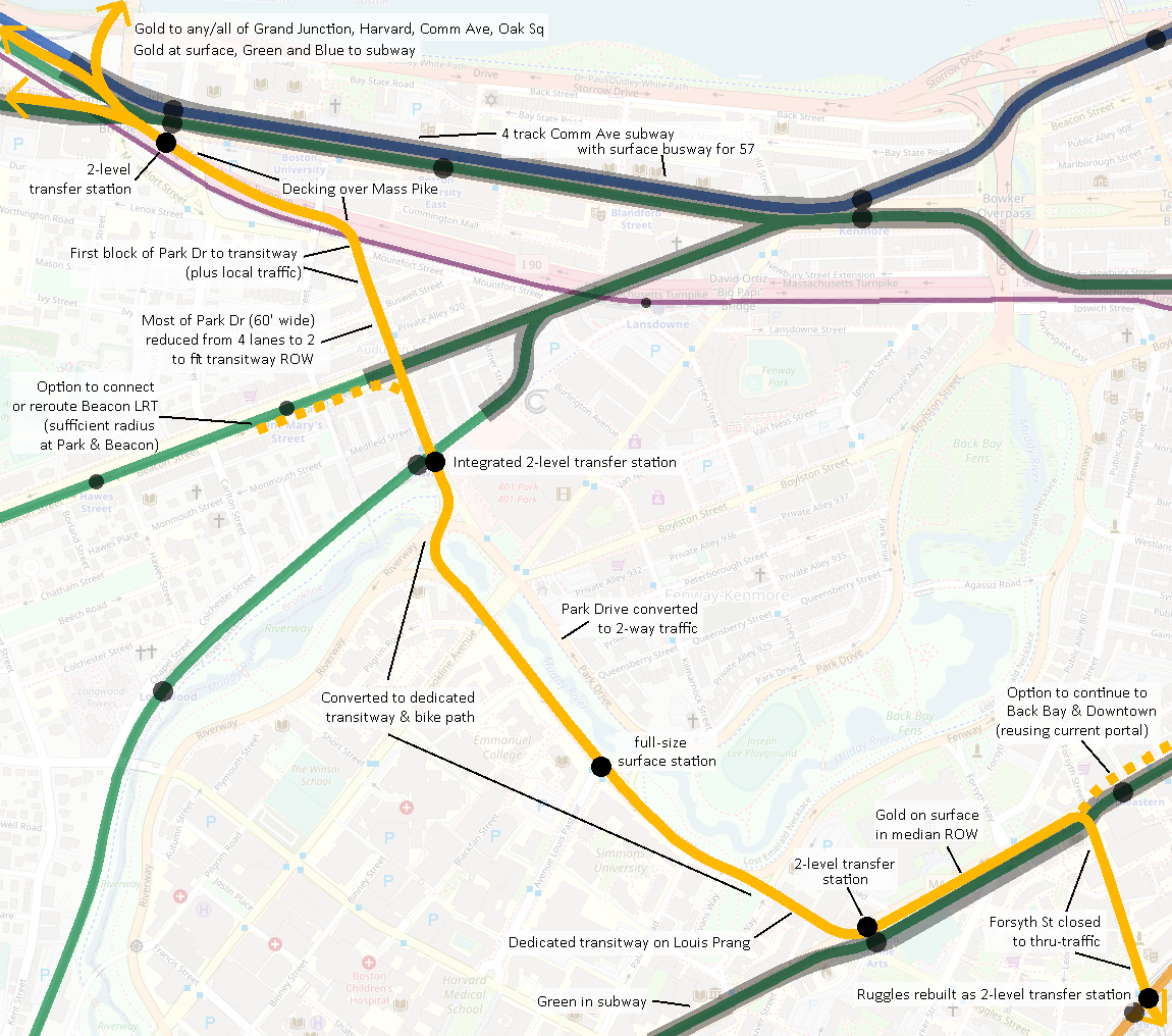
So — it seems like there could be real worth to finding a way through Longwood running roughly northwest to southeast. There is no perfect option here, unfortunately. But, I think there’s a real argument to make for an aggressive reimagining of Park Dr and the Fenway — I’m talking full-out reclaiming the public way from automobiles for mass transit (and with relatively low impact). Park Dr is reduced from 4 lanes to 2, and Fenway is converted to a green transitway along the Fens, with Park Dr on the opposite bank converted to 2-way traffic. The Fenway offers a unique opportunity for conversion: with the park on the north side, there is only one side’s worth of abutting neighbors — mostly Emmanuel College and Simmons University. Losing one street’s worth of auto access, and gaining major increased access to rapid transit, could make for a good bargain for those institutions.
A stop at Ave Louis-Pasteur would put riders less than a 10 min walk to many of the hospitals and major institutions:
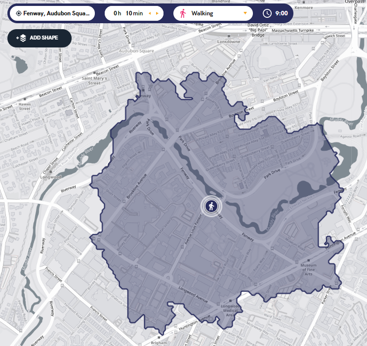
All in all, less than a mile of street would need to be reclaimed for transit use.
When I originally wrote this, I needed to leave early the next morning for some travel, so I cut to the chase and dropped the below diagram. Obligatory “yes this is far from perfect and yes people would scream bloody murder about it” but, if you can, just… imagine.
~~~
Since originally drafting the above, I’ve shifted to prioritizing this concept for providing circumferential service between Harvard/Allston and Longwood/Ruggles. This has prompted a couple of adjustments.
First, instead of using Forsyth, I would leverage the parcels along Ruggles St that the MBTA owns to create a dedicated ROW.
Second, while I remain convinced that Park Dr could receive a road diet to create a ROW along there, I’m less confident about being able to cross BU’s campus by way of the Mass Pike.
An alternative would be to interline with a Gold Line wraparound subway (indicated with dashed line below):
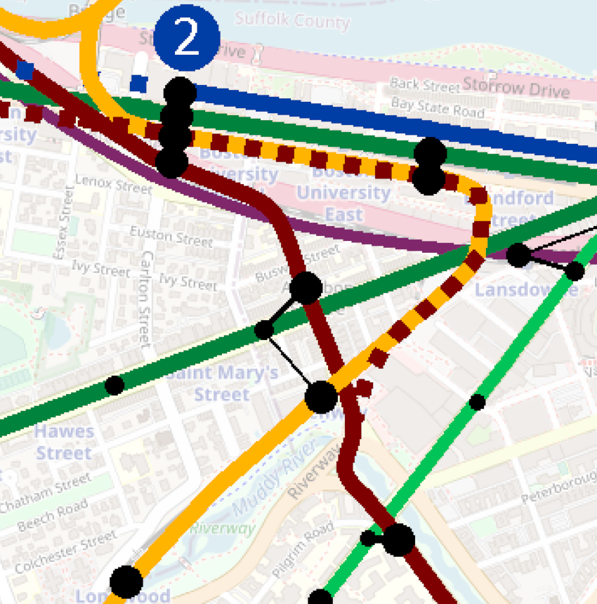
It would be a little tight to access the portal, and it would reduce the isolation between different characters of service, but it’s still an idea.
Originally from ArchBoston discussion here.