
This post builds on earlier work here.
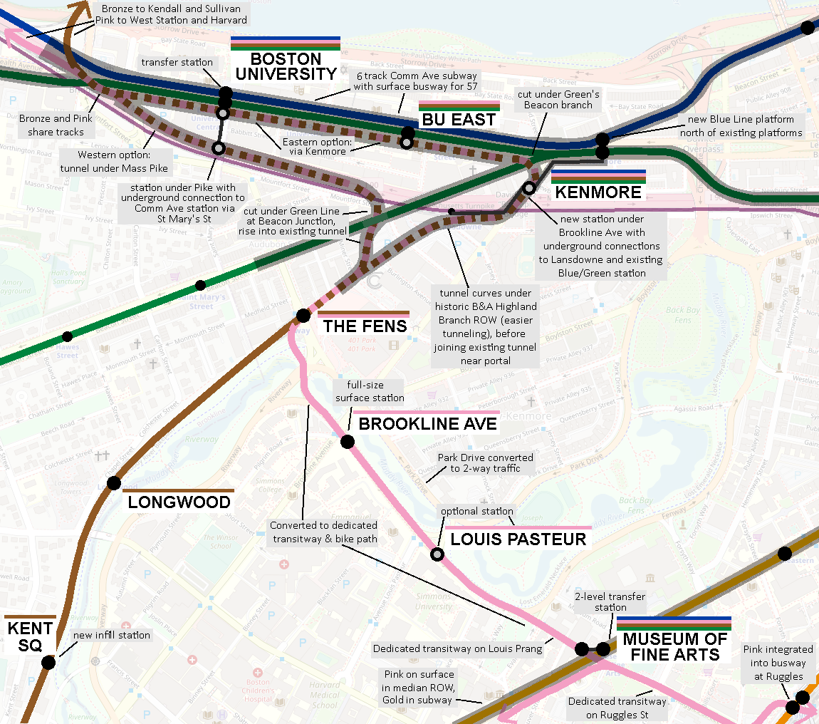
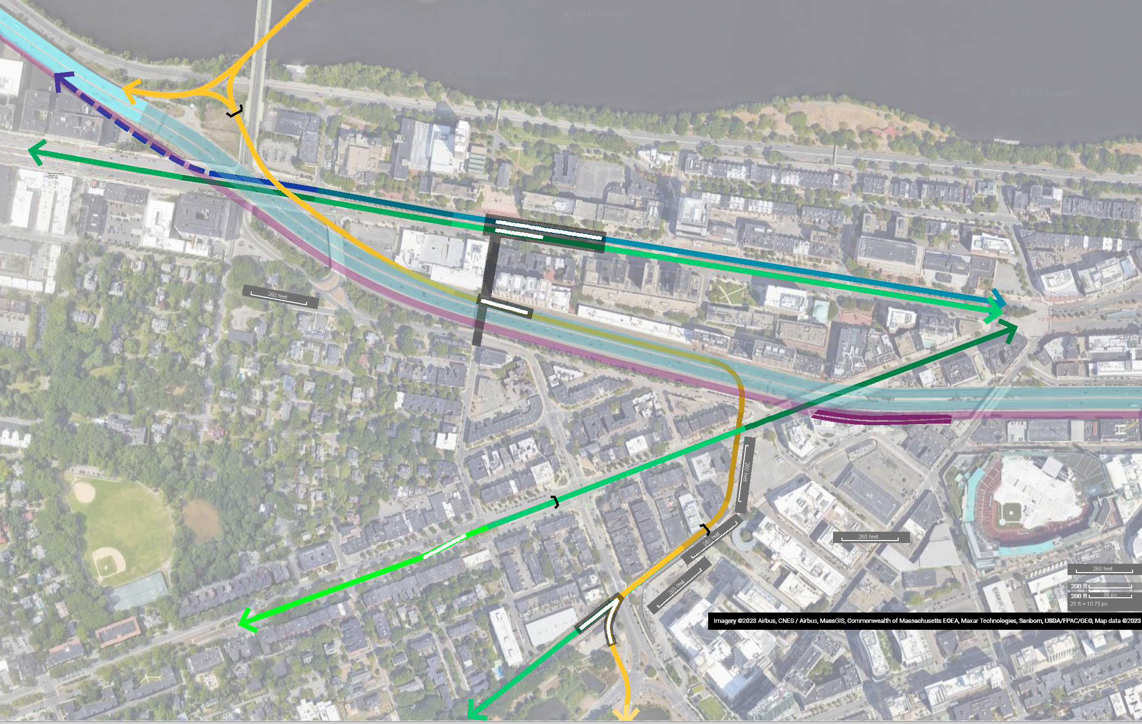
This first diagram depicts a “Longwood transitway,” and additionally includes a depiction of two subway options for reaching Fenway station (renamed “The Fens”) from the BU Bridge junction where light rail from Cambridge will be crossing the Charles. Credit for the Eastern option goes to Teban54.
This post uses several colors to indicate the new circumferential services coming from West Station & Harvard, and Kendall & Sullivan. I will simply call these services the “Urban Ring” in the text, regardless of the color.
In the following discussion, “-1, -2, etc” are shorthand for how many “levels” deep a tunnel is. This is not a precise measurement of depth, but is largely an indication of how many rights-of-way must fit above the tunnel at that particular point. Surface level is “0”, and the Mass Pike’s trench is “-1”.
Contents
Longwood transitway
An aggressive reimagining of Park Dr and the Fenway would create a vital link across Longwood Medical Area, providing a crucial connection from Ruggles to the eastern and northeastern parts of the network.
In my proposal, the Fenway (the road) would be fully converted for transit and bike use. This could be done highly aesthetically, with ample greenery, park benches, even perhaps pieces of art. Depending on network needs, this could be a dual LRT/BRT transitway to support both buses and light rail.
Park Dr (on the opposite bank of the Muddy River) would be converted to 2-way traffic to accommodate. Existing intersections can be modified to ensure continued “north-south” access between Longwood and the Fenway-Kenmore neighborhood:
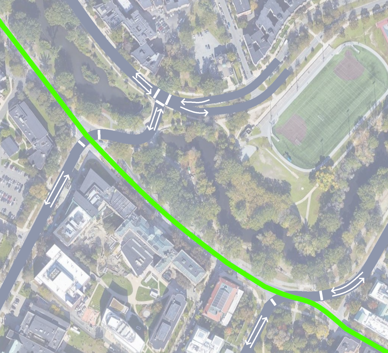
The Fenway offers a unique opportunity for conversion: with the park on the north side, there is only one side’s worth of abutting neighbors — mostly Emmanuel College and Simmons University. Losing one street’s worth of auto access, and gaining major increased access to rapid transit, could make for a good bargain for those institutions.
A stop at Brookline Ave would be valuable for the significant bus transfer opportunities there, as well as better access to hospitals such as Beth Israel. An intermediate stop at Avenue Louis Pasteur would also be valuable, to provide direct service to the northeastern section of Longwood, though I would prioritize a Brookline Ave stop over Louis Paster, if needed; as can be seen below, the walksheds for Brookline Ave and the existing MFA stop overlap significantly.

As illustrated in the walkshed map, the Longwood Transitway serves the northern (primarily academic) half of Longwood well, but still leaves about half of the hospitals more than 10 minutes away. This is somewhat unsatisfying, but it’s important to keep in mind the dual roles of the Transitway:
- Bring riders to Longwood
- Bring riders through Longwood
That second objective is where the Transitway proposal really shines: as described below, riders to Longwood can be adequately served through other routes, but getting across Longwood is a thorny problem that has historically been addressed with proposals for expensive tunnels.
But by offloading some of the responsibility for bringing riders to Longwood, the Transitway can focus on getting riders across Longwood in the most expeditious fashion possible — and it can do so without any tunneling, with less than 1 mile of road being reclaimed for transit use, in a cost-effective unobtrusive manner.
Combined with the (at one time official) proposal to add a dedicated transitway on Ruggles St, and the new subway described below, the Longwood Transitway could connect the major transfer hub at Ruggles with a one-seat ride to Boston University, West Station, Allston, Harvard’s Allston campus, and Harvard Square itself. More than just benefiting Longwood, the Transitway would have a systemwide impact.
Eastern option: via Kenmore
This (slightly simplified) diagram illustrates the concept of the Eastern option, with a new station placed under Brookline Ave, and a set of tracks for the Urban Ring running alongside the Green Line tracks in the new subway. (Stations + platforms other than Kenmore are not indicated on this diagram).
One challenge of this alignment is the need to interface with the Muddy River Conduit, which runs under Brookline Ave along the same alignment presented here.
One other complexity is the number of grade changes that would be necessary as part of this alignment.
At the western end at BU Bridge, there should be no problem: the “diverging route” that runs Comm Ave <> BU Bridge stays level and curves parallel to the Mass Pike, while the “tangent route” that continues under Comm Ave simply has to start dropping early enough to drop to -2 to clear the Pike and the diverging tunnel. It’s over 750 feet between St. Mary’s St and Carlton St, so there should be plenty of space.

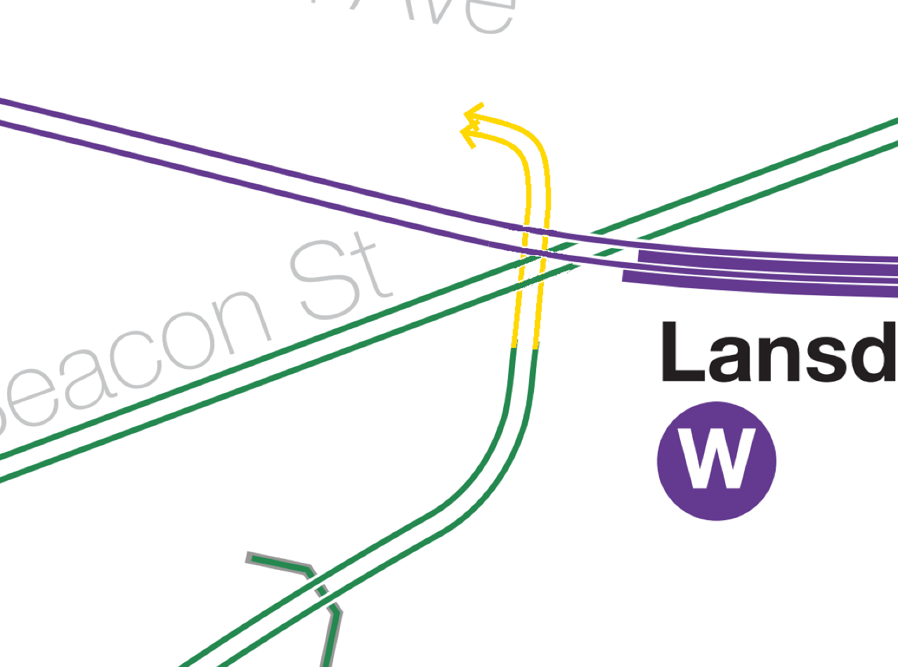
At the eastern end it’s a little more complex, but quite doable. Continuing to borrow Vanshnookenraggen’s track map for illustration purposes (Blue Line omitted for simplicity):
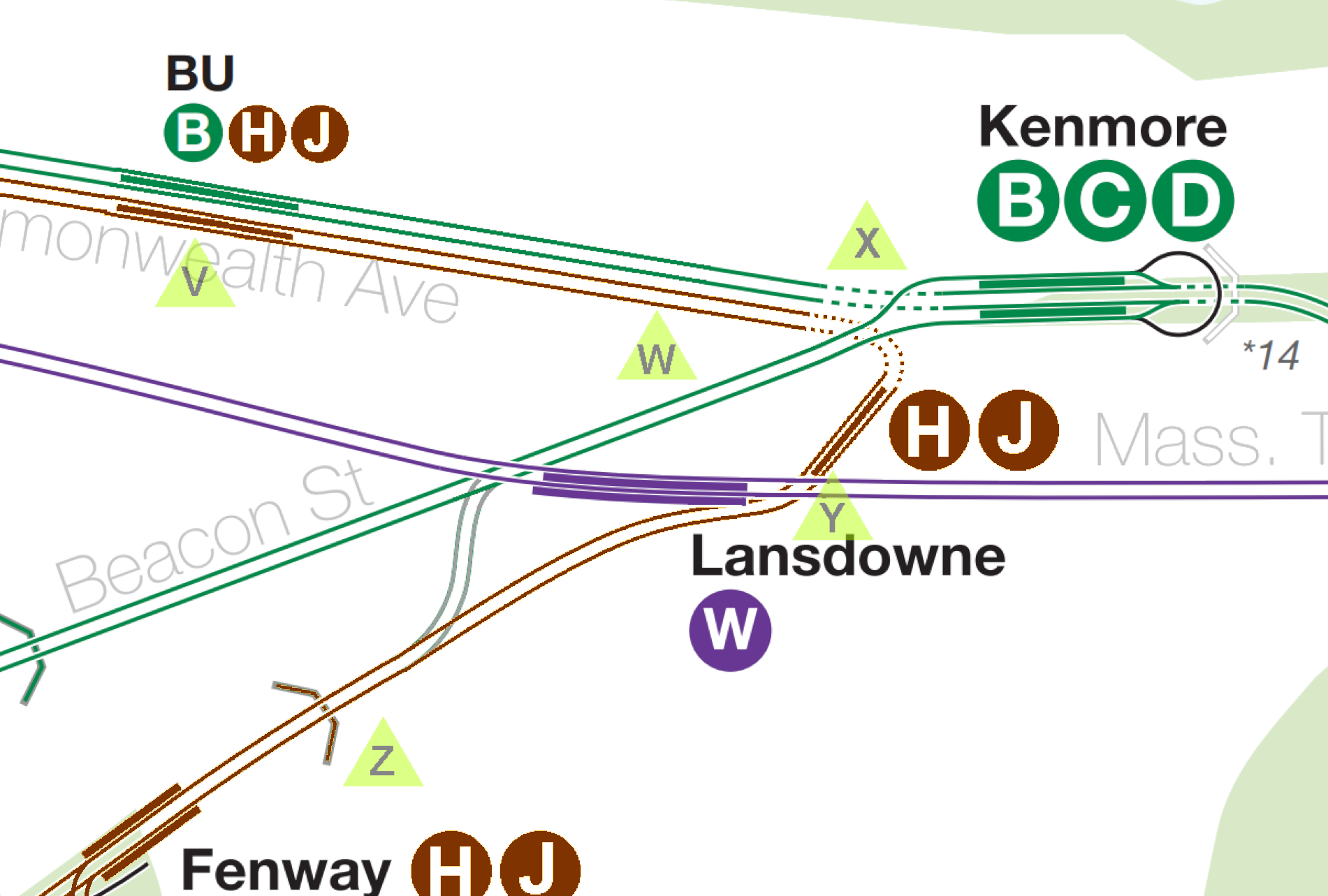
At Point V, the two subways can be parallel and really at any depth we want, but probably at -1. Around Point W, both subways will need to start descending.
Point X is probably the most dicey part, grades-wise, although not for the Urban Ring itself; the Urban Ring will need to have dropped to -2 to cross under the Beacon Street Subway, and there’s ample room for that descent on Comm Ave. The concern I have is the Beacon Street Subway itself: somewhere around Point X, it needs to start its own descent to clear under the Mass Pike at -2. If it starts that descent immediately, it might impinge on the ROW we’re looking at for the Urban Ring’s curve (clipping the ceiling). If so, we either need to push the Urban Ring deeper, or partially reconstruct the Beacon Street Subway to accommodate.
At Point Y, the Urban Ring needs to be at -2 to sit under the Pike (and potentially deeper if there’s a mezzanine for those pedestrian connection tunnels). But again, that should be okay from a grade perspective, since it already will need to be at -2 to cross under the Beacon Street Subway.
Then it’s just a matter of rising from -2ish at Point Y to the -1 portal at Point Z. There’s something like 1,000 feet there — enough even to rise from -3 to -1.
So I think that should all be okay. The only question mark is whether the “C-D Connector” (shown in grey) would need to be reworked to accommodate a sharper descent in the new subway. But, again, there is plenty of running room, so the new subway would not need to dive immediately after the portal.
Note that the diagram is not perfectly to scale. That’s fine — I’m not using it for precise measurements, but just to illustrate how the different pieces fit together.
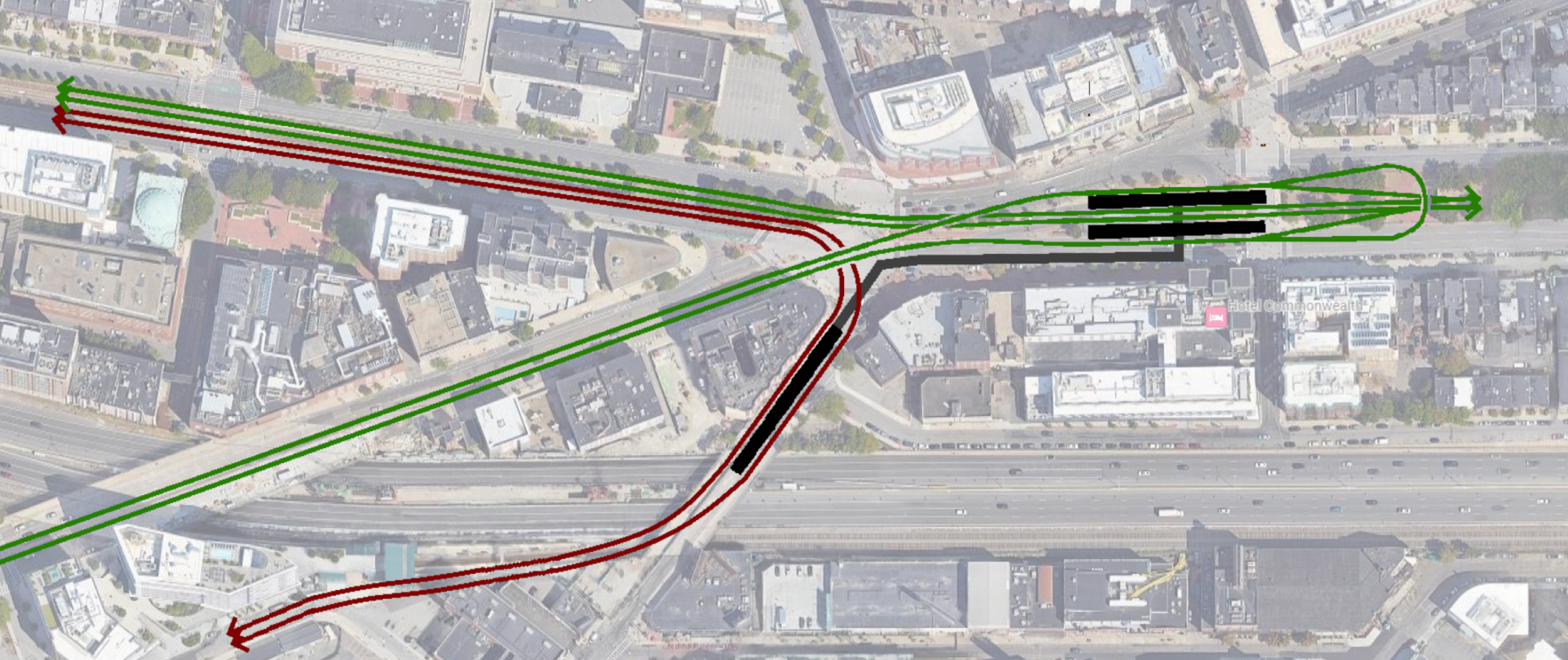
Western option: tunnel under Mass Pike
This diagram provides additional detail on the Western option (tunneling under the Mass Pike). Color changes in the diagram indicate grade changes:
Commonwealth Ave:
The Comm Ave subway (shown here with both Blue and Green Line tracks) runs in a shallow cut-and-cover -1 subway until around St Mary’s St, after which it does a (gradual) decline to -2 to pass under both the Urban Ring and the Mass Pike.
The Urban Ring (shown in gold above) does a shallow cut-and-cover in a -1 subway from its portal near the bridge, until it crosses over the Comm Ave subway, at which point it starts to quickly drop to -2 so it can cut under the Pike. It needs about 260 feet of horizontal distance to do this, so it should be able to reach the needed depth just east of Carlton St. (Potentially sooner, depending on if the Comm Ave subway can be shifted into the northern lanes of the Avenue.) Beyond there, it runs cut-and-cover under the Pike.
By running the Urban Ring tunnel parallel to the Pike under Comm Ave, the Green/Blue Line can avoid deeper tunneling.
Beacon Junction:
Just a little bit east of the BU Engineering Research Building, the Urban Ring curves south while completing its descent to -3. (Particularly if it hugs the northern side of the Mass Pike, there should be ample space here to build an industry-standard 82′ curve radius.) The curve targets alignment with the short tangent stretch of tunnel currently used by the D Line in its approach to the flat junction with the C Line. Terrible sketch using Vanshookenraggen’s track map:
The new tunnel passes under the Beacon Street Subway at -3 and then quickly ascends into the existing D tunnel. By using the existing D tunnel as a “jump off” point for digging our new tunnel, we can avoid cut-and-cover on the surface — instead, we do cut-and-cover under the existing subway.
I’m not totally sure about the existing grades in the tunnel — it’s possible that the entire tunnel, plus some of the incline at Fenway station, would need to be dug out to make for a steeper grade sufficient to do the necessary elevation changes. But, as I’ve tried to indicate with the placement of the 260′ scale markers, there should be enough distance between Fenway station and the Beacon Subway to make the necessary drops within the existing ROW’s footprint (even if none of the extant physical track would be used).
Boston University station:
This alignment uses parallel stations at/near St. Mary’s Street, joined by a pedestrian tunnel underneath the street, with headhouses on Comm Ave and Mountfort Street, and probably on the northern edge of the Pike for the BU buildings there. Pedestrians cross the highway below ground level behind fare control. (Optionally, this tunnel could have sections inside and outside of fare control, if better connections across the Pike were desired by the community.)
The horizontal distance between platforms and headhouses is within the realm of existing downtown transfers, though the level of vertical circulation is less than ideal; the north-south pedestrian underpass would need to dip all the way down to -3 in order to clear under the Urban Ring, which would require some long escalators which in turn likely increases the horizontal distance. It’s the most painful for commuters going between Comm Ave street level and the Urban Ring — will require four stories’ worth of escalators (3 down, 1 up), plus something like 300′-350′ of walking.
Eastern vs Western
If feasible, the Eastern alignment is definitely better.
One way or another, this section between the BU Bridge and Fenway station would need 2 sets of LRT tracks (one for the Green Line and one for the Urban Ring): the necessary grade changes make it impractical to consolidate into a single set of tracks. (And that would be undesirable from a capacity perspective as well.)
Additionally, even if not built right away, I’d want to future-proof a Blue Line tunnel through here as well, and I think Comm Ave could handle 6 tracks. Comm Ave would be easier to dig under than the Mass Pike, and obviously the Eastern alignment’s station under Comm Ave is better than the Western’s under the Mass Pike (with its long escalators and pedestrian tunnels).
The double-back of the Eastern alignment is somewhat inelegant, and the extra stop at Kenmore would increase travel time. But a transfer at Kenmore would also be extremely valuable, especially since it reduces the pressure to extend the Blue Line to BU in an initial build (since the Urban Ring<> Blue transfer would be available at Kenmore, and a Commuter Rail <> Blue transfer would be made easier with an internal connection between the stations).
The Eastern alignment would allow a non-revenue connection between Fenway and the Beacon St Subway to remain extant, which I do think would be valuable.
Plus, another station at Kenmore/Lansdowne would be invaluable with crowd distribution during during and after Red Sox games, where these stations get a lot of traffic.
That being said, both alignments will require underpinning an existing Green Line tunnel, either at Kenmore or at Beacon Junction; if one of those locations is significantly easier to build at, then that would likely tip the scales in favor of one alignment or another.
Why bother with these at all?
The Urban Ring corridor has two very different halves: the northern half, where the Grand Junction ROW provides a virtually uninterrupted path from Airport to Sullivan to Kendall to Commonwealth Ave; and a southern half, which faces multiple obstacles and will be extremely challenging to build.
The axis between north and south unfortunately puts Longwood Medical Area in the less accessible half of the circle. A light rail service from Kendall and Sullivan can almost make it there, but the lack of a clear path beyond Comm Ave creates one final obstacle.
One saving grace is the portion of the current D Line between Fenway and Brookline Village (which I call the “Fenway Branch”); with the Gold Line, D trains would be rerouted to Huntington and this track would be unused. Repurposing the Fenway Branch for the Urban Ring would provide access to Longwood in a reliable, grade-separated ROW, without any new construction required within the tight confines of the LMA. This could handle the objective of bringing riders to Longwood (as described above).
With that in hand, we have dedicated, protected, nearly entirely grade-separated ROWs all the way from Chelsea, Everett, Sullivan, and Kendall directly to Longwood… except for this one area — less than 2,000 feet wide, between Commonwealth and Fenway — creating a gap.
Closing that gap unlocks the full potential of the entire northern Urban Ring corridor (and would help enable a Harvard <> Ruggles connection as well). A BU <> Fenway connection isn’t just about improving service to BU or Fenway — rather, it would hypercharge the entire network. Just as the Longwood Transitway would have impact stretching from Ruggles to Harvard, a subway closing this gap would reverberate in its effects throughout the entire region.