
I like imagining new lines. Obviously it’s fun to draw lines on a map, but I really do believe that there is an element of placemaking to naming a route as a “line”. This can be misused and abused, but I believe that the concept itself is not inherently problematic. What’s more, I believe that “linemaking” can be a way to put individual projects into a systemic context, and help knit the region together.
So, with all that in mind, I present: the Navy Line.
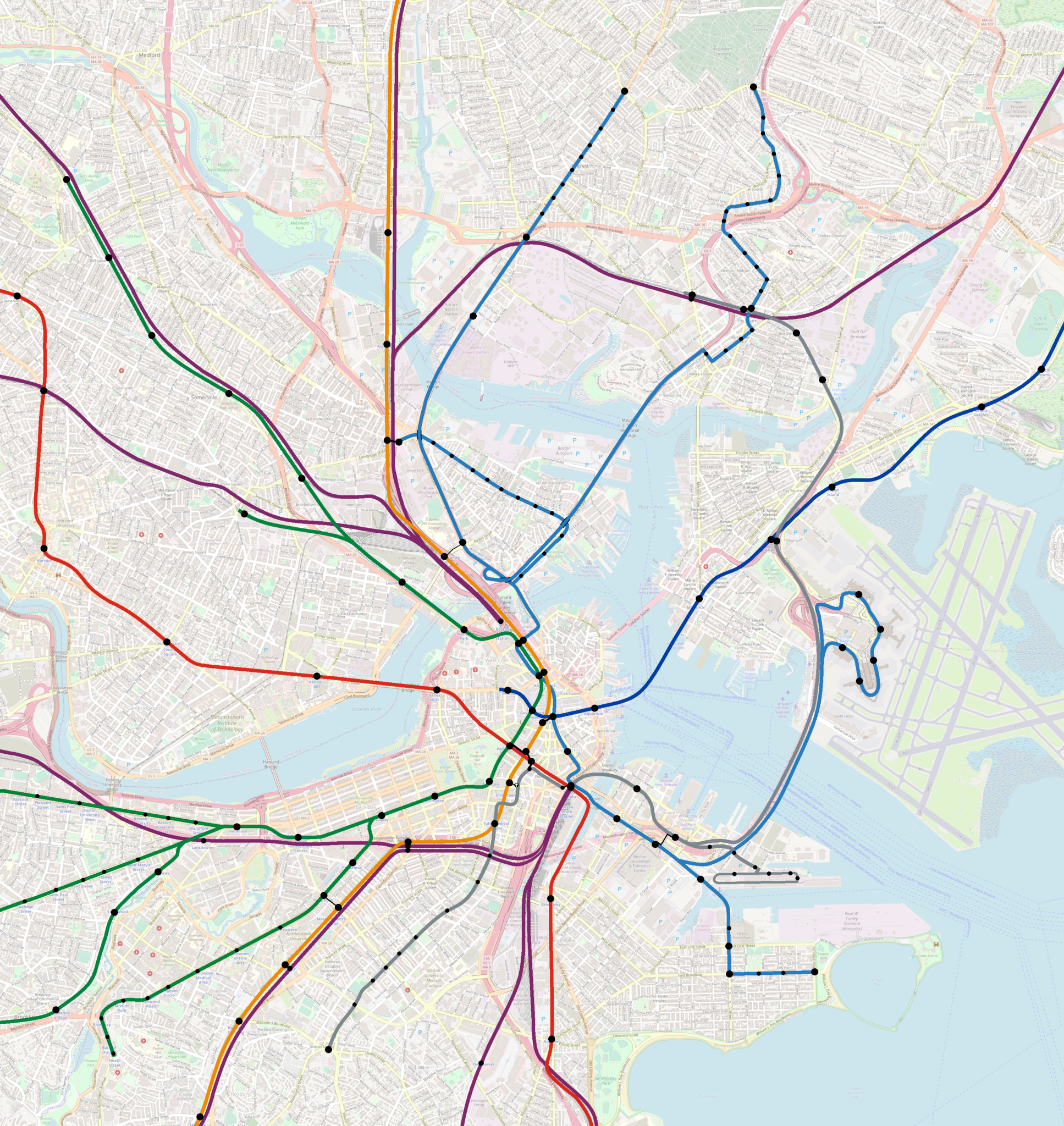
So-named due to its service of the Charlestown Navy Yard park, and for its unparalleled six water crossings, the Navy Line is largely an amalgamation of existing BRT proposals, with a couple of modest additions. It takes its cues in part from the B/C/E branches of the Green Line, which are characterized by local bus stop spacing on the outer branches, and rapid transit stop spacing on the core trunks. Also like the Green Line network, the Navy Line includes short-turn services to accommodate variable reliability on its outer branches.
Originally conceived of in 2021, the Navy Line could now be considered an amalgamation of the Bus Network Redesign’s proposed T7, T111, parts of the T109, and the current SL1 service.
Contents
Core and Southside
The core of the Navy Line draws on the “Center City Link” concept, proposed in Dec 2019: dedicated bus lanes running from North Station to South Station to Summer Street. While the exact route is not yet defined, in general these are multilane streets with plenty of room for bus lanes. High frequency bus service through the Financial District and from North Station to the Seaport would relieve crowding on the Orange Line.
Core
This section would largely be a combination of the current 4 and 7 buses, and mirrors the T7 proposal. Stops in the core would be:
- North Station (Green, Orange, commuter rail)
- Haymarket (Green, Orange, express buses)
- State at State & Congress (Blue, walking transfer to Orange)
- Financial District between Franklin and High
- South Station (Red, Silver, commuter rail)
- Fort Point between Melcher and A St overpass
- BCEC (walking transfer to Silver at World Trade Center)
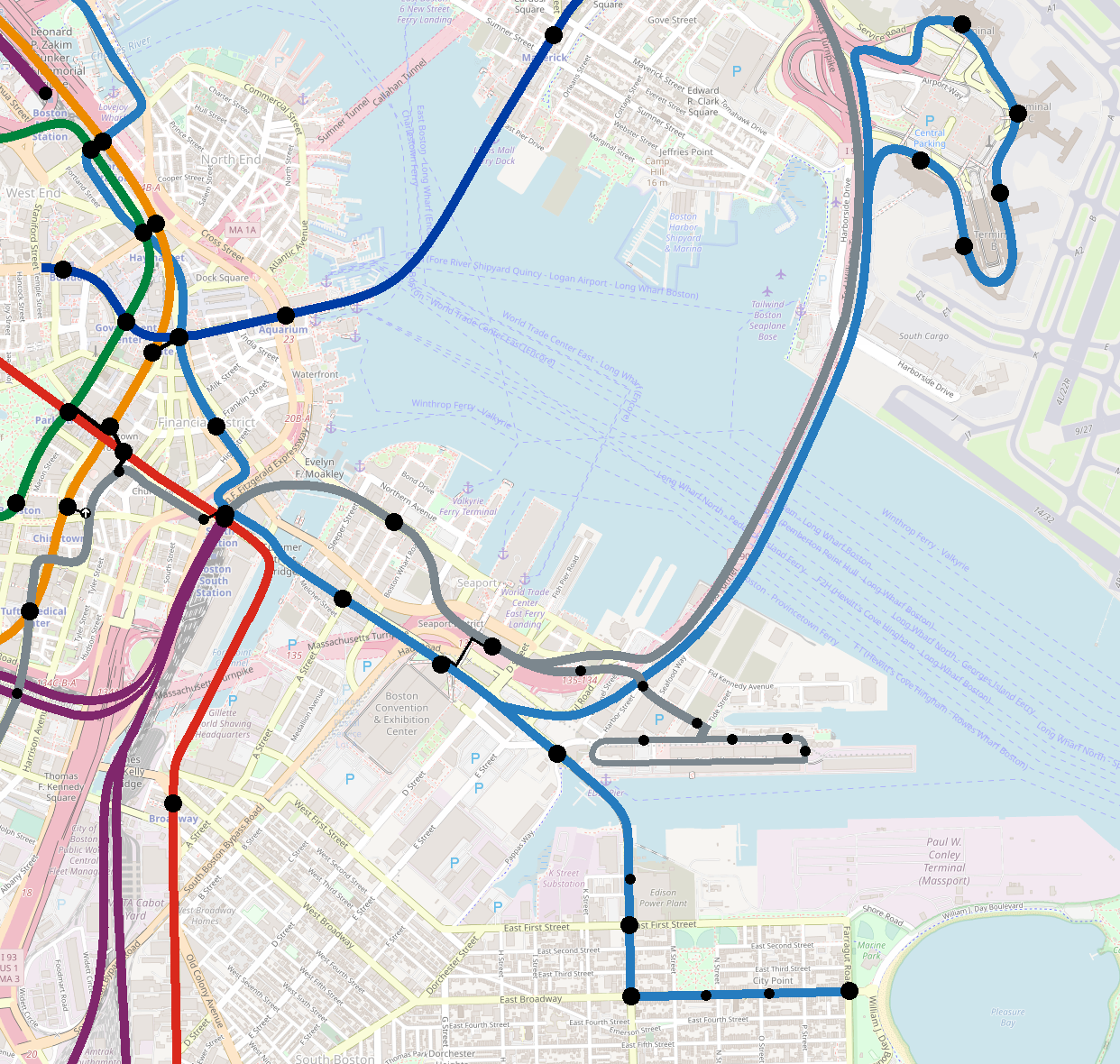
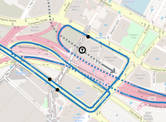
NV1
The first southern branch, designated NV1, would serve Logan Airport, and provide a one-seat ride between Logan, the Financial District and North Station. This branch would replace the current SL1 service, in favor of the more direct service to South Station (where the large majority of SL1 journeys are heading) and further service into downtown, again reducing crowding on the core subway lines.
The map above shows a simplified representation of how the Navy Line would access the Ted Williams Tunnel. The actual routes would be:
- Toward Logan
- From Summer St, turn left on D Street
- Turn left on Haul Road
- Enter the I-90 on-ramp
- Continue to airport in tunnel (ideally with dedicated lane)
- Toward Downtown
- Exit the Ted Williams Tunnel on to Congress Street
- Turn right on Congress St (repainted with a one-way bus lane on this block)
- Stop outside World Trade Center station
- Turn right on D Street
- Turn right on Summer Street
(The westbound route is similar to the current SL1/SL3 route.)
NV2
The second southern branch would replace the 7 bus and run to City Point, designated NV2. (This mirrors the current Silver Line branching scheme where the “1” branch goes to the airport, and the “2” branch continues southeast.) This branch would have a mix of major and minor stops:
- Drydock Ave (walking transfer to Silver at Design Center)
- Power House Street
- E 1st Street
- L & Broadway (transfer to the 9 and 10)
- O & Broadway
- N & Broadway
- City Point (exact location TBA)
Some NV2 services would through-run beyond North Station, but most if not all NV1 services would short-turn at North Station, due to the unreliability of traffic in the Ted Williams Tunnel.
Northside
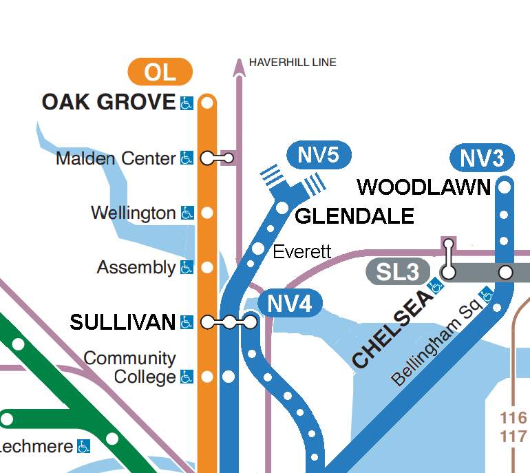
To the north, the Navy Line would have three branches: NV3 to Chelsea, NV4 to Charlestown, and NV5 to Everett.
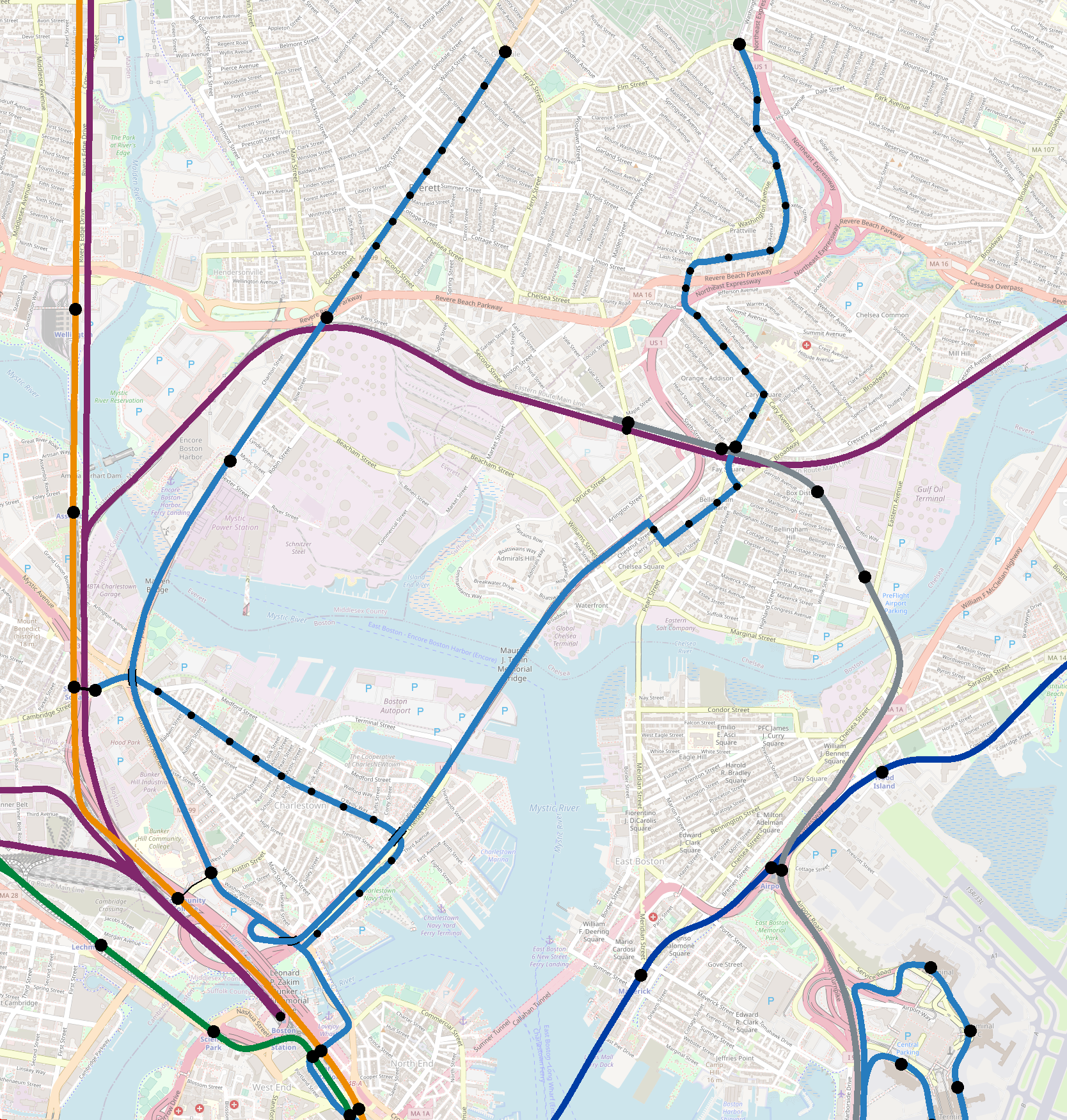
NV3
NV3 would utilize dedicated lanes on the Tobin to run express to Chelsea and then run locally to Woodlawn, with short-turns at Cary Square — today’s 111. To my knowledge, there are no proposals to add bus lanes in Chelsea, so this branch would be mixed-traffic for the foreseeable future. However, the 111 is important enough to it merit inclusion in this new line, and the presence of dedicated lanes on the Tobin would add some element of “rapidness”.
NV3 complements but does not replace SL3. SL3 is good for accessing the Airport and the Seaport, but NV3 would offer direct access to Downtown, and direct transfers to the Orange and Green. Given its lengthy mixed-traffic, and its overlap with SL3, NV3 would likely short-turn at South Station to accommodate the variable reliability of the street-running segment in Chelsea.
NV4
NV4 would run to Sullivan Square via Bunker Hill Street, mirroring today’s 93. This pair-matches well with the current 7 to the south, and so is a logical candidate for the Center City Link. The Bus Network Redesign’s proposal to run this service as the all-day high-frequency T7 bears out the argument that this corridor merits enhanced service.
Dedicated lanes along Bunker Hill Street would require elimination of parking (politically challenging), but some improvements could be made using strategically placed queue jumps. Peak-only “soft” bus lanes could also be effective. That being said, much of Chelsea Street (paralleling the Route 1 viaduct) is four lanes, and could receive dedicated lanes, speeding service to/from the heavily-used southern half of Bunker Hill Street. (Note that some sort of accommodation would need to be made for current riders who board southbound along Lomey Way and east of City Square.)
In principle, most NV4 service could through-run to City Point as NV2. This would really depend on how many improvements can be made to improve reliability along Bunker Hill St — the fewer the improvements, the worse the reliability, and the fewer buses that can be through-run to South Boston.
NV5
NV5 is a bit different from all other branches, in that it really is a net new service, rather than an amalgamation of existing services. Running express in dedicated lanes on Rutherford Ave and Route 99 (proposed by the Lower Mystic Regional Working Group), and then running locally in bus lanes along Broadway to Glendale Square at Ferry Street, this would supplement, not replace, the likes of the 104 and 109, which would continue to run to Sullivan Square, and run beyond Glendale Square to Malden Center and Linden Square. It might also supplement an SL3 extension to Sullivan, Lechmere and Kendall, which provide a circumferential complement to NV5’s radial route.
One key distinction between my proposed NV5 and that of the Lower Mystic Regional Working Group is that the NV5 bypasses Sullivan and runs non-stop between Community College and Encore Casino. I realize this is highly debatable, but my reasoning is that Sullivan itself is not the ultimate destination — rather it is a transfer hub. Riders who are destined for downtown only currently go to Sullivan because they need to transfer to the Orange Line; a direct service would eliminate that need. (Given that Bunker Hill Community College is a proper destination unto itself, it seems worth including a stop there as well.)
For riders destined for Cambridge or Somerville (i.e. who will be transferring to another bus at Sullivan), the 104 and 109 will continue to provide that feeder service, and an SL3 extension might capture some of those riders as well. The 104 and 109 would still benefit from the bus lanes along Broadway, so there would be significant reliability and travel time improvements for circumferential riders.
However, bypassing Sullivan is hardly make-or-break for this proposal — if the numbers merit it, it’s easy enough to add it in. It would be a minor drain on travel time, but not earth-shattering. Moreover, since there are proposals for dedicated bus lanes on the entire NV5 route north of Sullivan (and easy enough to add them on Rutherford), this route can afford a little extra travel time.
Due to its higher reliability, the NV5 would typically through-run to City Point as the NV2.
NV5 rolling stock
It is fair to point out that — unlike the other aspects of the Navy Line concept — my proposed NV5 service would not be net-neutral for rolling stock. All the other branches leverage routes that largely already exist, with very slight extensions. No matter how you slice it, the NV5 would require rolling stock to support an additional 1.5 miles of bus route; with luck, that segment will be speedy and use dedicated lanes, so the necessary increase should hopefully be small, but still non-zero.
NV5 and 104+109
In this scenario, I’ve described the NV5 as a supplement on top of the 104+109. However, an alternate version would see both the 104 and 109 subsumed into the Navy Line network, superextended via high-speed bus lanes on Rutherford.
If I recall correctly, when I was first developing this concept, the 104 and 109 both sat at 18-min peak headways; this meant that the combined section could have “turn-up-and-go” frequencies of 9 minutes, but that the individual “branches” still required consulting a schedule.
I feel that a service should not be placemade as a “line” unless it’s properly a “turn-up-and-go” service, so that would point away from incorporating the 104 and 109 themselves into the Navy Line. However, the 104 and 109 now each sit at 15-min peak headways, which puts them right on the edge of “turn-up-and-go”, making the distinction less clear.
One option would be to include both the 104 and 109 as Navy Line branches, but only include the shared segment to Glendale on the subway map — perhaps using dotted lines to indicate continuation of the service but at a meaningfully different standard.
In that case, it might be possible to create the NV5 with near-net-neutral impact on rolling stock by repurposing the buses currently allocated to the 104 and 109. Slight frequency reductions on the “branches”, combined with expanded busways along the entire route, could potentially enable through-running beyond Sullivan into downtown, with “turn-up-and-go” frequencies as far north as Glendale. This would require further study.
NV5 and T109
NV5 does represent the largest break from the Bus Network Redesign’s proposals, which instead extends a hypercharged T109 from Sullivan to Harvard. I think there are good arguments in favor of both options — Everett-Downtown and Everett-Harvard.
Everett is the only community directly abutting the City of Boston that does not have a one-seat ride to downtown. While it is true that there are many employment centers outside of downtown, downtown remains both job-dense and transfer-dense. Running NV5 to downtown provides two-seat riders from Everett to nearly every corner of Greater Boston; running the T109 to Harvard improves only a subset of journeys. That’s why I personally favor the Downtown option.
That being said, the Navy Line remains a perfectly viable proposal even absent NV5. As I describe below, what we’re really talking about here is a new BRT subnetwork, which can easily adapt in the future, taking on new services.
SL4 and SL5
Since the cancellation of Phase 3 of the Silver Line, there have been two nearly-but-not-quite joined segments of the line: Washington St and Seaport. The institution of SL4 service to South Station was a reasonable best effort to join the two together, but they still remain disparate.
The creation of the Navy Line offers an opportunity to reintegrate Washington St BRT service into a proper network. The characteristics of SL4/SL5 align much more with the Navy Line concept than with SL3: the former run at surface level in dedicated lanes and sometimes mixed traffic, while the latter runs in tunnels and a dedicated busway with rapid transit stop spacing.
As branches of the Navy Line, Washington St service could through run into downtown and beyond, and/or finally achieve the goal of a one-seat ride from Nubian to the Seaport and Logan, via Summer St and the NV1 routing.
The history of SL4/SL5 is troubled and fraught. I believe the Navy Line concept offers opportunity, but I also recognize that Roxbury and the South End have long felt that promises of good transit remain unfulfilled. Shifting from Silver Line service to Navy Line service does not solve the inherant problems of the current situation, but it does prompt us to imagine new possibilities.
Names
I have used the term “Navy Line” here because it “fits” in several ways: serving the Navy Yard, multiple water crossings, plus the use of colors beyond ROYGBIV for BRT services, à la the Silver Line. This is reminiscent of the Blue Line being so named because it travels under the ocean, and the Green Line for the Emerald Necklace — “and the Navy Line is so named because it serves the old Navy Yard!” is in some ways just too clever to resist.
There are some drawbacks. Most people think of “navy” as a dark blue, and the T’s current branding for the Blue Line definitely puts it on the darker end of the blue spectrum. It would make more sense for a new “blue-related color” line to be colored a light blue. I’ve tried to split the difference in my maps in this post, but it’s a bit of a stretch.
But there are alternatives. This could be the Aqua Line (with a pale blue) or perhaps the Teal Line (making sure to not appear too green). The T could also opt to add some variety to its line names: keep the light blue color, but call it the “Water Line” or the “Harbor Line.” As much as I enjoy imagining new lines and drawing them on a map, there are people whose literal job is to figure out the best name and color for a line, so I happily defer to their expertise on this topic!
Conclusion
BRT — especially in the United States — is often misused, and has developed a poor reputation accordingly, often seen as a halfaloaf alternative to badly needed rail investment. However, I would argue that this proposal is one where BRT is actually a good fit. The high number of water crossings means that radial rail service would be costly; there is a natural trunk-branch topology that lends itself well to rapid-transit-ification; and, critically, there is some measure of community support and political will to bring these kinds of enhancements to fruition.
If the T is going to continue to expand BRT service, it will eventually become necessary to create differentiation within the branding — if the “Silver Line” runs everywhere, then it loses its placemaking significance. Creating a second BRT brand would enable clearer messaging, and clearer wayfinding. NYC colors its lines based on trunkline, and a similar approach could be used here: Silver Line uses the Transitway, while Navy Line uses the Center City Link.
Finally, it bears mentioning that this would allow the T to add an entirely new line to the map — with the vast majority of the needed infrastructure improvements being paint on the ground. Future enhancements could include better shelters, level boarding, even pre-payment. But, for the most part, all that would be needed are some newly painted lines on the ground, some level of political enforcement, and probably a few extra buses.