
From https://archboston.com/community/threads/green-line-reconfiguration.5003/page-56#post-448346
This post uses yellow/gold as the color for a Grand Junction “Urban Ring” service. I am in the process of updating this to Bronze, as I now use “Gold Line” to refer to a separate proposal.
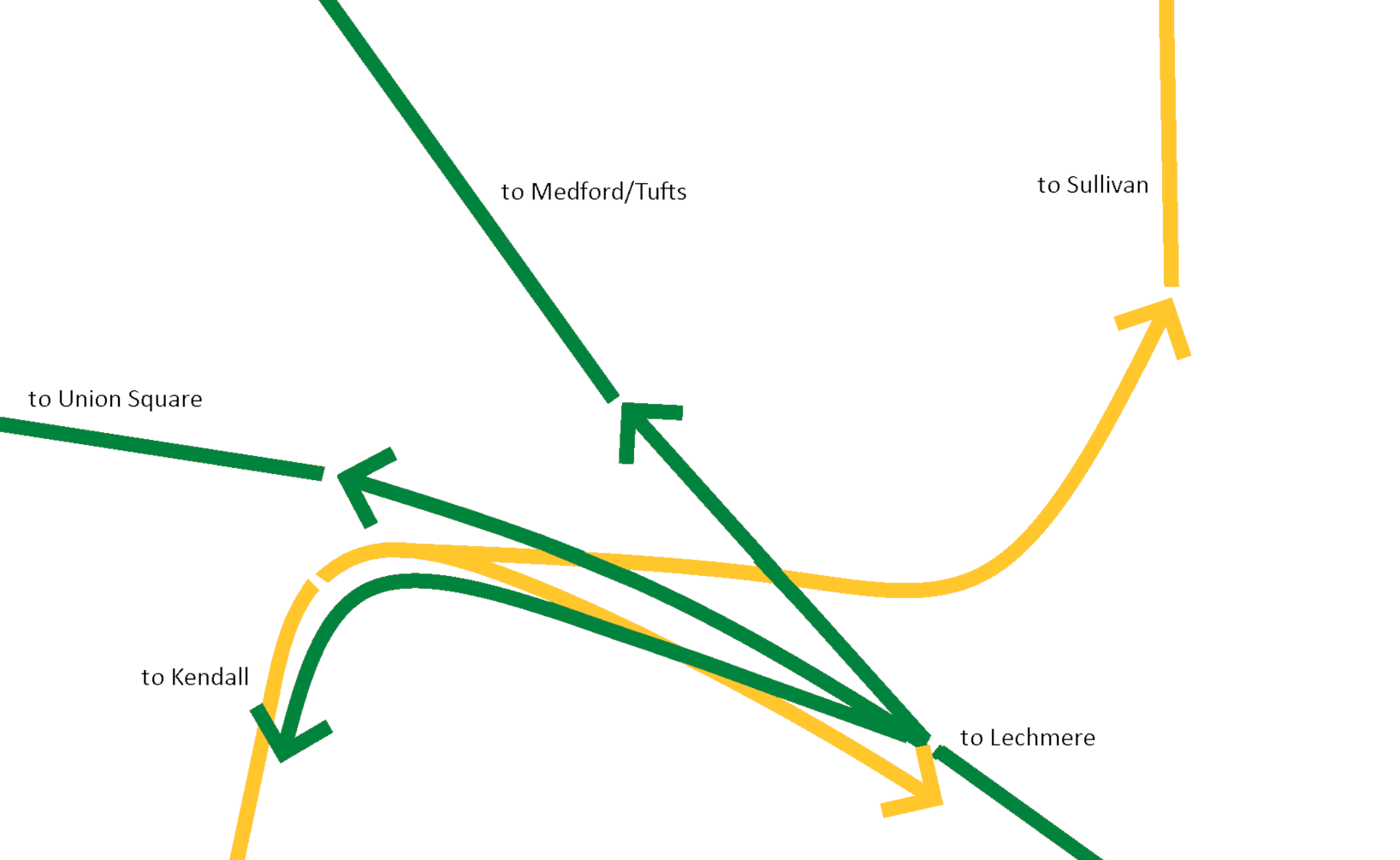
Sketch here, details below:

I describe this as a “half-Aldgate” junction because I’m not proposing connecting every line with every line. For the purposes of this document, I am limiting the scope to the following service patterns:
- Lechmere <> Medford
- Lechmere <> Union
- Cambridge (Grand Junction) <> Sullivan
- Cambridge (Grand Junction) <> Lechmere
Our “starting point” is the current Green Line, plus a new LRT line that goes between Sullivan and Kendall (and beyond) via the Grand Junction Line:

Abstractly, what we are looking to accomplish is something like this:
We can also conceptualize this as a pair of north-south trunk lines, each spreading out into multiple branches:
- Central Subway (Lechmere), to
- Medford/Tufts
- Union Square
- Grand Junction
- Grand Junction (Kendall), to
- Sullivan
- Lechmere
The Central Subway <> Grand Junction (Lechmere <> Kendall) service could equally be considered a branch of the “Gold Line” or of the Green Line — it’s really just an arbitrary wayfinding decision which to go with, and I’m largely going to sidestep that question in this document.
I am excluding Lechmere <> Sullivan; as I’ve detailed elsewhere, I don’t believe that this route is the best use of resources, and while the Lechmere -> Sullivan piece is very easy to build, the Sullivan -> Lechmere piece will be nasty, and either be inordinately inexpensive (tunneling or super-elevateds) or introduce bottlenecks (flat junctions).
Contents
1. Lechmere <> Medford and 2. Lechmere <> Union
These are handled by the existing GLX infrastructure, which should require little modification.
4. Cambridge (Grand Junction) <> Lechmere
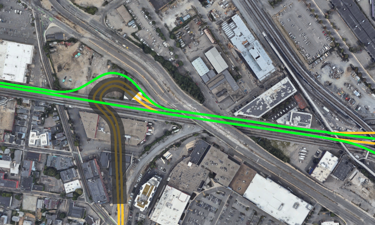
Westbound: Lechmere -> Grand Junction
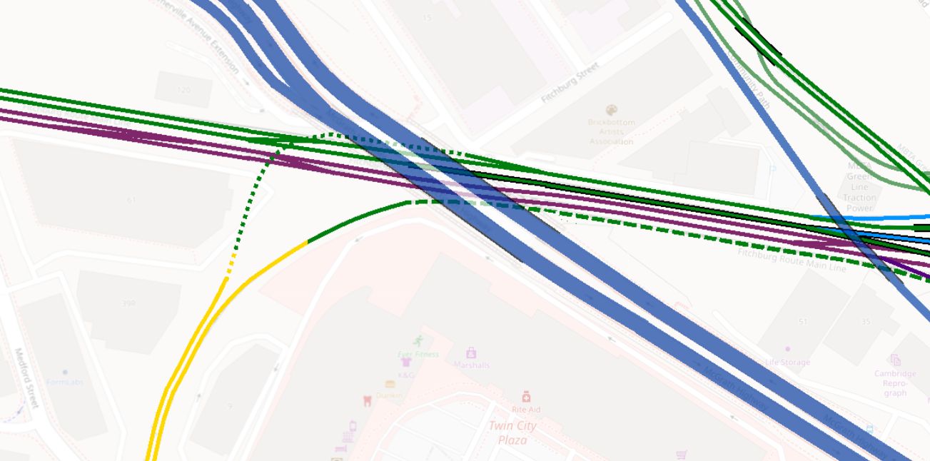
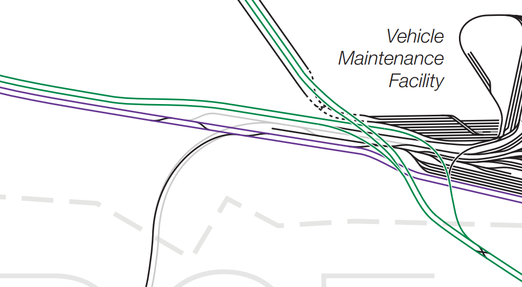
Going westbound, you reclaim some/all of the Somerville Avenue Extension road alongside the ROW as it crosses under McGrath Highway, branching off the Union Branch at the corner of the Brickbottom Artists’ Association building, and start diving down below grade level (shown in dotted green here). I’m not sure of the exact depth an underpass would need to be in order to safely cross under the Union Branch and Fitchburg Line; that said, a 6% grade reaches a depth of 20 feet in 333 feet of running distance, which just about fits in under the McGrath overpass. Once underground, there should be enough space for a gentle curve (i.e. 80′ radius or better) that avoids the foundation of the nearby building before tunneling under and then surfacing within the Grand Junction ROW.
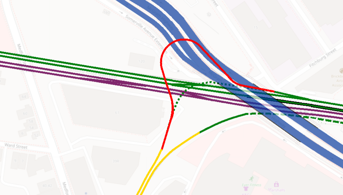
If 20 feet isn’t deep enough for an underpass, we can achieve 660 feet of running space to enable a 40 foot depth by cutting under the McGrath Highway embankment to swing wide into a question mark shape. Even with 85′-radius curves, it should be possible to avoid the building foundations. See the route in red (shown in solid color, but would be a tunnel for most/all of its length):
Eastbound: Grand Junction -> Lechmere
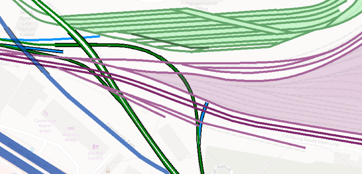
Going eastbound, we are basically going to clone the Union -> Viaduct incline and put it south of the mainline tracks. Now, this will require a little bit of rearrangement. There are currently three mainline tracks between McGrath and the Viaduct (let’s call them North, Middle, South):
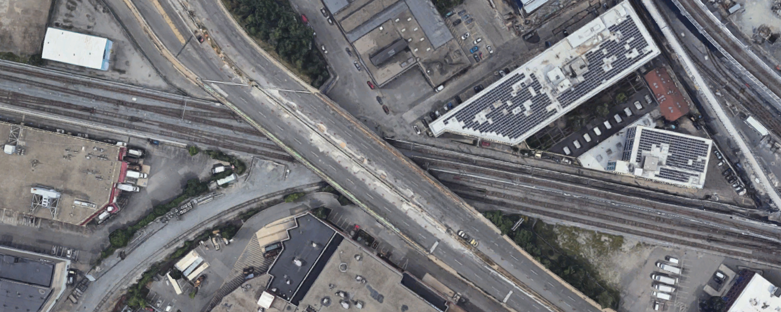
Vanshnookenraggen’s track map is helpful for illustrating what’s going on here; Middle and South are the through tracks, while North is a stub-end:
And a photo I took from an inbound train on the Viaduct also helps, somewhat:

As can somewhat be seen in the above photo and more clearly visible in the StreetView, there is available space next to the South track (possibly with some relocated support pillars). But, as the ROW continues east, it becomes constrained by the buildings at the eastern corner of the lot (as visible in the photo).
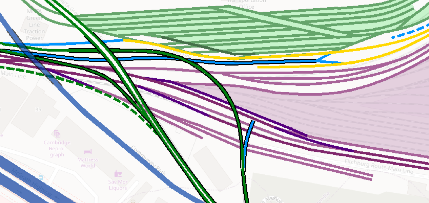
So I propose using the wiggle room available underneath the McGrath overpass to shift the mainline tracks “up” one “slot”.
Before:
After:
This opens up the slot of the South track to create the new incline, and join the Viaduct just south of the current merge (new incline shown as a dashed line):
Note that you still will need to fit the new incline under the Community Path. I think this will be doable, though it may be necessary to relocate the Viaduct merge further south than I’ve shown it here (if you need to duck lower than I’ve estimated to clear under the Path, in which case you need additional running length to rise up to meet the Viaduct, which should still be doable).
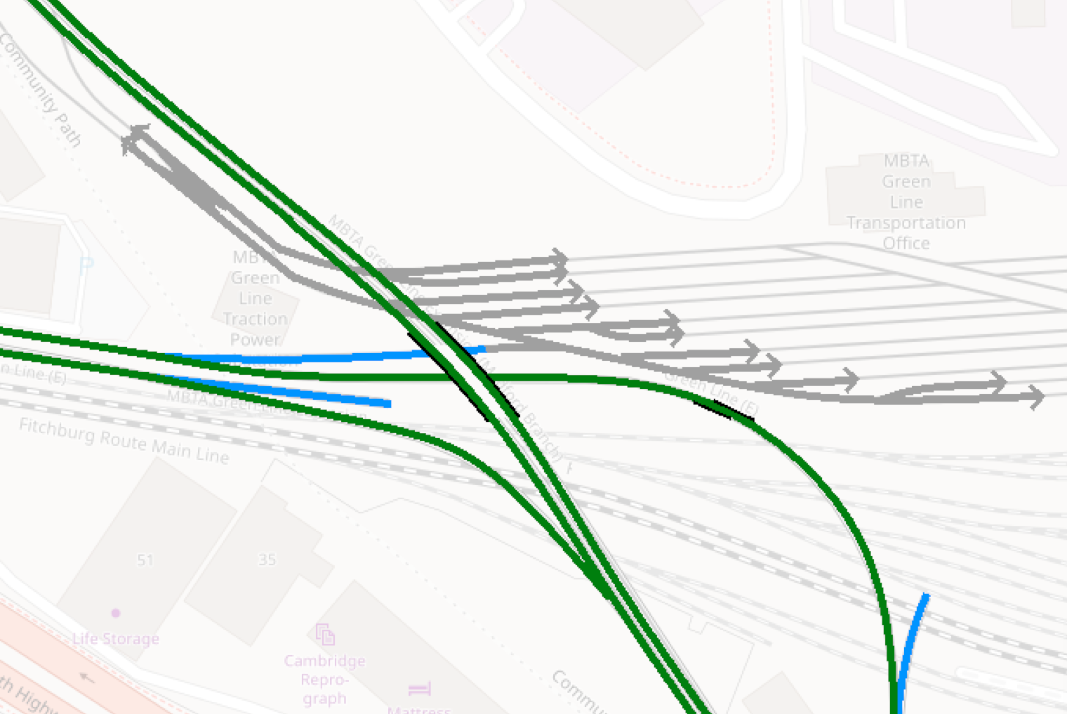
Rearranging the mainline tracks
You’ll also need to do a little bit of rearranging of the mainline tracks on the eastern side of the Viaduct, including weaving through some support beams, but it shouldn’t be anything super aggressive. In the diagrams, light purple is used for the non-revenue mainline tracks, mid-purple is the typical revenue mainline tracks, and dark purple is new track that would need to be built to reconnect things (and the light purple fill is the yard, where I didn’t draw out all the tracks).
Before:
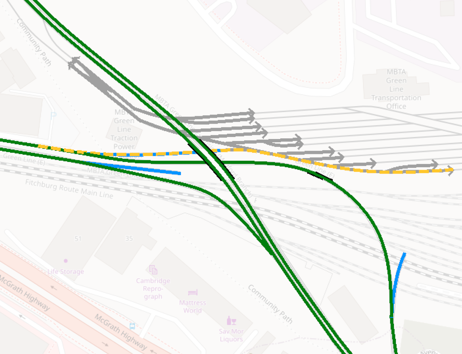
After:
(Spoiler alert, this screenshot also includes new LRT tracks to support Grand Junction <> Sullivan, but I’ll get to that.)
At this point, you now have a grade-separate flying junction that supports Lechmere <> Grand Junction service without creating crossing conflicts with other services.
3. Cambridge (Grand Junction) <> Sullivan
Half of this one is very easy, and half of it is very much not. Let’s start with the easy one.
Westbound: Sullivan -> Grand Junction
Going westbound this part of the junction is already built, in the form of the yard lead running from the GLMF to the Union Branch. With some modifications to the yard tracks, you have your revenue tracks connecting Sullivan to the Grand Junction (via the underpass discussed above) right there.
If you want to go all out (or include in a subsequent enhancement build), you could look at adding a parallel track north of the current track, connecting the current yard lead to the diverging track at McGrath, so that Sullivan -> Cambridge trains don’t need to interfere with Lechmere -> Union trains. The problem here is that you would be right up against the back walls of the adjacent buildings, and I’m not sure how close you can actually put an active RoW against a building like that.
The parallel track would be valuable, as this stretch will otherwise see all:
- Lechmere -> Union
- Lechmere -> Cambridge
- Sullivan -> Cambridge
trains, so this stretch could become a bottleneck. But even without the parallel track, I think it may still be workable.

Eastbound: Grand Junction -> Sullivan
Going eastbound is where things get hairy. Coming from Cambridge, this track needs to cross over or under:
- McGrath Hwy
- The Cambridge -> Lechmere incline
- The Fitchburg Line
- The Community Path
- The BET yard leads
- The Union -> Lechmere incline
- The Viaduct
- The Lechmere -> Union incline
- A potential future Lechmere -> GLMF yard lead incline
Running flat at-grade will be a non-starter, unless you plan to sink the Fitchburg Line tracks, which will be both cost- and space-prohibitive. Running elevated looks more possible at first, but would need to weave under the Community Path, over the Viaduct, over the Lechmere -> Union incline, and then somehow interface with the Lechmere -> GLMF incline (probably needing to pass over it altogether). Alternatively, one could “go wide”, remaining at surface level south of the Fitchburg Line from one side of the junction to another before rising into a separate viaduct over the BET. In both cases, however, I think that you can’t make the necessary height changes within the short distances while still maintaining a 6% grade.
So, it’s a tunnel. A short tunnel, but a tunnel, taking what I think is the most direct (shortest) route, but which also happens to cut right through the heart of Brickbottom Junction. Hopefully it could be dug in stages to reduce disruption to Fitchburg service, but it definitely will not be pretty. On the other side, it surfaces to join one of the tracks repurposed from the GLMF Yard to continue to Sullivan. (In the diagram below, the dashed blue line indicates a surface track that could connect to a Lechmere -> GLMF incline, if ever built.)
If memory serves from when I first sketched this out, the paths I’ve drawn should give enough running distance to drop 20 feet below surface by the time the tunnel hits the mainline tracks. On the eastern end, there is plenty of space to lengthen that if needed. It’s a bit trickier on the western end, but I think it should be possible, if needed, to relocate the Cambridge -> Lechmere/Sullivan divergence point further west in order to provide additional distance to fit a drop to a greater depth than 20 feet.
Summary and Conclusion
The good news is that this design can be built in stages: the Lechmere <> Cambridge leg can be built more or less independent of when the Sullivan <> Cambridge leg is built. The bad news is that I don’t see a way to run Cambridge -> Sullivan without some tunneling.
Broadly speaking, if the T is willing to buy up some real-estate and/or use a TBM, it could be possible to build a flying interchange west of McGrath Highway, and then leverage the yard leads going from the Union Branch to the GLMF. This would be a simpler but likely costlier design, and would create bottlenecks going both eastbound and westbound. A rough sketch (don’t look too hard at the turn radii, this is just the general idea):
But, aside from that, my thinking comes down to the following pieces of new construction:
- A Lechmere -> Cambridge underpass at/west of McGrath (medium)
- A Cambridge -> Lechmere incline south of the mainline tracks (hard)
- A Sullivan -> Cambridge connection via the existing yard leads (easy)
- A Cambridge -> Sullivan underpass in the center of the junction (very hard)