
I know next-to-nothing about ferries and water transportation. But when has lack-of-expertise ever gotten in the way of drawing pretty lines on a map, amirite??
Ahem.
We can call this “EZ-Ride, the next generation: EZ-Float”.
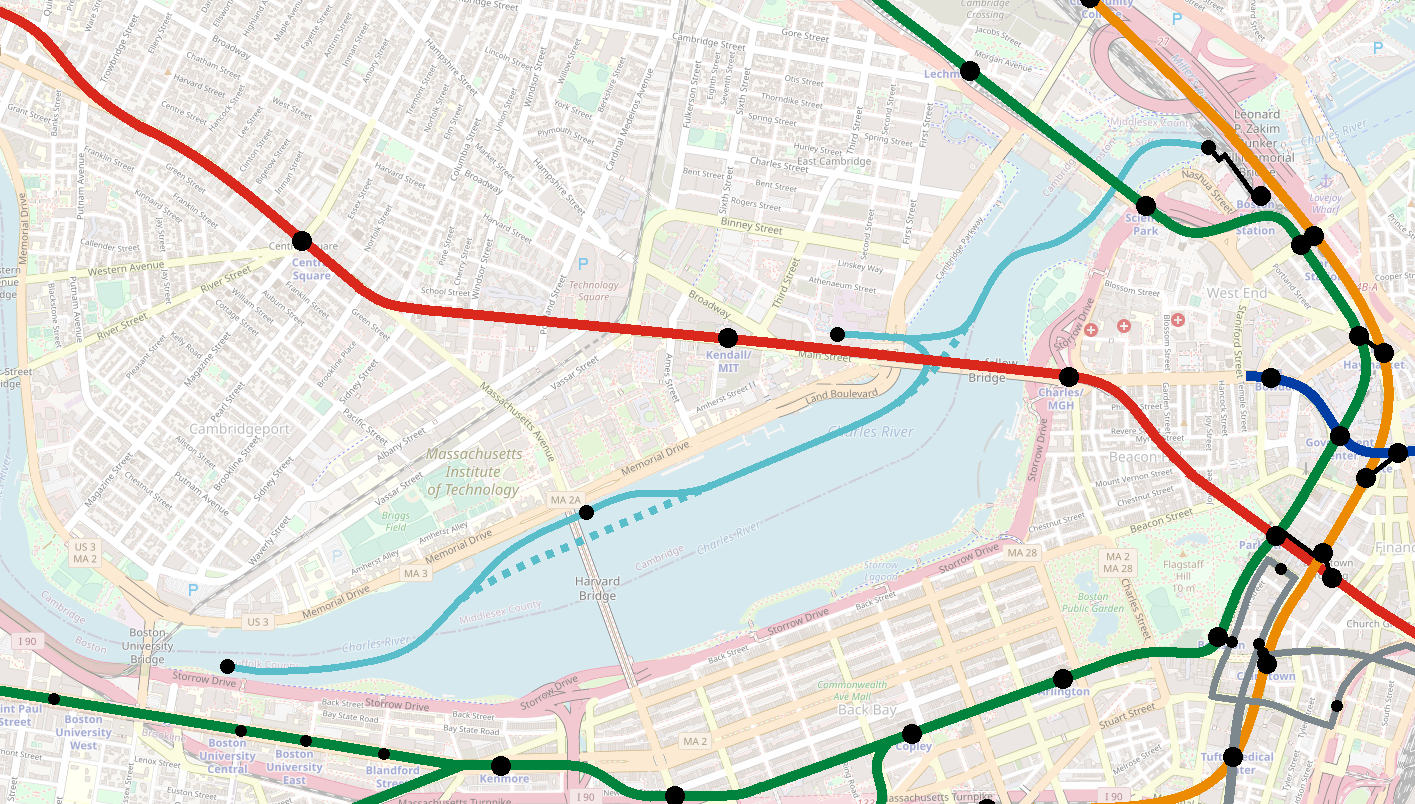
A Charles Ferry route, with stops at
- North Station
- Kendall
- MIT/Mass Ave
- BU
with optional non-stop runs to reduce travel times.
At North Station, plop a dock/use existing docks behind the MGH building, and add a pedestrian overpass from the far end of the commuter rail platforms so passengers can walk directly without diverting through the station.
At Kendall, see if you fit under the Broad Canal Drawbridge (lol no) to get closer to the heart of the action. If not, look for places to stop just north and/or south of Longfellow:
Ten minute walksheds from two possible stop locations — am slightly surprised the western one gets you a “deeper” walkshed, but probably is impacted by the spaghetti at the bridge, the canal, and the tracks themselves:
Plunk another stop somewhere near Mass Ave, and then (assuming you can figure out a way to fit under the low-clearance Massachusetts Ave Harvard Bridge), have fun picking a place to stop near BU:
~~~
Okay, so aside from the aesthetic/romantic appeal of the Charles River becoming more like the Thames (as a piece of geography that knits together the region, rather than split it), what does this proposal actually have going in favor of it?
Well, to start, you have the North Station <> Kendall commute, currently covered by EZ-Ride, which claims to be able to do the journey in 10 minutes. (The Green <> Red journey is timetabled at least 16 minutes.) A ferry could potentially provide greater reliability by bypassing traffic — if it can be faster.
Can it be faster than a bus? Well, maybe. The Charlestown Ferry is timetabled at 10 minutes to travel one mile, for an average speed at 6 mph. I have zero idea whether conditions on the Charles permit similar speeds, but it’s the only number I’ve got for now, so I’m rolling with it. (See note below — the speed limit on this part of the Charles is 10 mph, so 6 mph should be feasible.)
North Station <> Kendall-ish is also about a mile. So, that suggests that EZ-Float could actually compete with EZ-Ride on travel times, though the ferry gets a penalty due to the 5-10 min walk on the Cambridge side.
EZ-Ride also serves MIT, timetabled at about 20 minutes (depending where on campus). North Station <> Mass Ave via the Charles is 1.6 miles, which non-stop at 6 mph could be cleared in 16 minutes. Again, not a clear winner, but perhaps competitive if there is better reliability.
Finally, there is BU. North Station <> BU Bridge (as an arbitrary choice for a stop location) is 2.7 miles, which non-stop would be 27 minutes. North Station <> BU Central via the Green Line is something like 32 minutes, and requires a transfer or a 10+ minute walk. So, once again, we don’t see a clear winner, but it seems like there is a somewhat similar ballpark maybe.
~~~
One outstanding question is frequency and rolling (floating?) stock needs. For comparison, the T uses (I believe) two boats for the Charlestown Ferry service, for 15-minute service during peak. EZ-Ride’s frequency varies, but during high peak sees 12-minute headways.
Just to sketch out some numbers, let’s look at the “full-build” North Station <> BU service (and we’ll assume it’s non-stop for the moment). 27 minutes of travel time, plus 3 minutes per stop (probably a little tight) puts a round-trip at 60 minutes. To achieve 12-minute headways, you would need five ferries in operation at once. So a more realistic estimate would be six or seven, depending on how many stops you make and how tight your “layovers” are.
That’s… a lot of boats. Even just a North Station <> Kendall service would probably need three boats in order to hit those 12-minute headways.
There’s also a literal pinch point under the Craigie Bridge. Again, I know next to nothing here, but that looks pretty narrow and I’m guessing can’t handle two boats passing each other in opposite directions. So maybe 12-min headways aren’t even possible anyway.
~~~
So, does this work? Ehn, probably not. At least not as a competitive replacement for EZ-Ride. A one-seat North Station <> BU service every 15-20 or 20-30 minutes maybe could be potentially interesting, but hardly a slam dunk. A North Station <> Kendall route probably is the most nearly feasible (and certainly targets the greatest demand), but EZ-Ride probably provides sufficient service for now.
The outer harbor services (e.g. to Hingham) are (I believe) catamarans that zip along at 20 mph. So maybe there are faster boats out there that could make this trip competitive, I don’t know. They’d need to be pretty narrow to fit through the Craigie, which looks to be about 45 feet wide.
So, while it’s fun to imagine, the days of commuting under the Longfellow rather than over it are still probably pretty far off.
~~~
Post scripts:
It turns out that there is a cruise service that runs a similar route to this: https://charlesriverboat.com/vessels/charles-i/
JeffDowntown on ArchBoston says:
This is the quote from the Charles River Alliance of Boaters:
“Power boaters should plan on a one hour run from Sunset Bay, home to Newton Yacht Club, Watertown Yacht Club, and the public launch ramp, to the locks leading to Boston Harbor. The speed limit is 6 mph above the BU Bridge, 10 mph between the BU Bridge and the old lock by the Science Museum.”
I can’t find the exact source of that quote, but some rudimentary googling verifies this.
~~~
Part of the reason I didn’t go farther than Cambridgeport was because at that point the Charles begins to curve around and becomes much more roundabout for journeys to North Station; the interesting thing about the North Station <> Kendall pair is that the “as the crow flies” route is indeed directly through the Charles, so a water service can potentially be more direct. This is true to a lesser extent for the MIT and BU pairs as well.
That said, some upstream destination pairs would indeed be linked pretty directly via a path along the river:
- Harvard <> BU
- Harvard <> Arsenal
- Harvard <> Watertown
- Watertown <> Arsenal
So, like many transit routes, a Watertown <> North Station service could be built off of shorter journey pairs, even if the longer journeys are less competitive.
~~~
I suspect Kendall, rather than North Station, would be the primary destination for a Watertown service. A SWAG travel time estimate would put a Watertown <> Kendall ferry at one hour, which, compared to the current transit methods, is not super far off from the status quo:
(Of course, it should be noted that driving completely knocks both surface transit and ferries out of the water, no pun intended).
That being said, a Harvard <> BU ferry, at 6 mph, would take 15 minutes and would probably beat the current 2-seat transit journey:
So perhaps we should be looking at two ferry services:
- North Station <> Kendall
- Harvard <> Boston University
I think the thing that strikes me about all this is what a comment it makes about the current public transit system that going non-stop at 6 mph in a boat on a slightly circuitous route is broadly as fast as using transit (especially if there are any delays on the transit side).